Archaeological Sites: Identification, Survey Methods, and Preservation
An archaeological site is a physical location or group of locations where evidence of past human activity is preserved. This evidence can span from prehistoric eras to historic or even contemporary periods. These sites form a critical part of the archaeological record and can vary wildly in visibility; some may have no remains appearing above ground, while others consist of buildings and structures that remain in active use today.
Defining the exact geographical extent of a site is often a complex task. While a site is frequently associated with a settlement, archaeologists must also consider the surrounding areas of human activity. A site does not always have to be a village; a single burial or a hidden hoard of valuables can constitute a site. In the field of cultural resources management—where archaeology is driven by land development—site boundaries are often initially defined by the limits of the construction project, though researchers must still look beyond those borders to fully interpret the findings.
Many sites are discovered by chance. Farmers plowing fields, hikers, and pilots often encounter artifacts and report them to professionals. Once a potential site is identified, archaeologists record the area and, provided funding and time are available, begin the process of excavation.
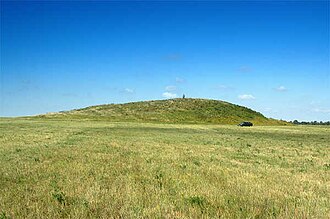
Key Facts
- Archaeological sites can range from massive ancient cities to a simple scatter of flint flakes from the Palaeolithic or Mesolithic eras.
- Artifacts are man-made objects, while features are non-portable remains like hearths or house foundations.
- Ecofacts are biological materials (bones, scales, feces) resulting from human activity but not modified by humans.
- Geophysics allows researchers to see subsurface structures without digging, though excavation is still required for verification.
- GIS (Geographical Information Systems) is used to map locational data and track previous research in a specific area.
Methods of Site Discovery and Survey
Archaeologists use various strategies to locate sites, ranging from traditional foot surveys to high-tech remote sensing.
Field Surveys
Field surveys involve walking across the land to analyze the terrain and search for surface artifacts. Researchers often target areas likely to have supported human populations or locations mentioned in historical documents. Some may also use random sampling within a specific area to determine the likelihood of finding a site.
Geophysical Surveys
Geophysics is an increasingly popular branch of survey that uses instruments to investigate the ground without disturbing the soil. While these methods provide a visual representation of what lies beneath, they are not entirely reliable and must be confirmed through digging.
- Magnetometry: This technique measures and maps patterns of magnetism in the soil using a magnetometer.
- Ground Penetrating Radar (GPR): This method sends radar pulses (electromagnetic radiation in the microwave band) into the subsurface and detects reflected signals from buried structures.
Mapping and GIS
To organize their findings, archaeologists use Geographical Information Systems (GIS). By plugging survey data and archival research into GIS, they create maps that combine locational information with various data layers. This allows researchers to see what has already been discovered in an area and expand their research accordingly.
Site Composition and Formation
Traditionally, a site is identified by the presence of artifacts and features. However, different theoretical approaches change how a site is defined. For example, landscape archaeology views discrete units of activity within the context of the wider environment. Meanwhile, geoarchaeologists or environmental archaeologists may study natural geological or organic depositions even if no human activity is present.
| Category | Definition | Examples |
|---|---|---|
| Artifacts | Objects made or modified by humans | Pottery, tools, coins |
| Features | Non-portable human-made remains | Hearths, walls, post-holes |
| Ecofacts | Natural biological remains linked to humans | Animal bones, seeds, feces |
Preservation and Burial Processes
Sites are formed by human processes but are shaped by post-depositional natural factors. Buried remnants are generally better preserved than those exposed to the elements. Common burial processes include:
- Alluvial: Sediment deposited by water.
- Aeolian: Sediment deposited by wind.
- Vegetative: Decomposed plant matter creating soil layers, common in jungles.
- Colluviation: The burial of a site by gravity-driven sediment, also known as hillwash, typically occurring on slopes.
Human activity also contributes to burial. In many cultures, new buildings are constructed directly on top of older ones, a phenomenon that has led to the development of urban archaeology.
Frequently Asked Questions
What is the difference between an archaeological site and an archaeological discovery?
An archaeological site is the physical location where evidence of past activity is preserved, whereas a discovery refers to the specific act or finding of an artifact or feature within or outside such a site.
How does GPR differ from magnetometry?
Magnetometry maps magnetism patterns in the soil to find anomalies, while Ground Penetrating Radar (GPR) uses microwave radar pulses to create images of subsurface structures based on reflected signals.
What are ecofacts?
Ecofacts are biological materials, such as bones, scales, or seeds, that result from human activity but were not deliberately modified by humans.
Why is GIS important for archaeologists?
GIS allows archaeologists to integrate locational data with archival research, helping them map existing discoveries and identify unexplored areas for future research.
What is colluviation?
Colluviation is the process where a site is buried by sediments moved by gravity, often referred to as hillwash, which typically happens to sites located on slopes.