Amapá: Brazil's Pristine Rainforest Frontier
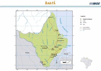
Located in the far northern reaches of Brazil, Amapá is a state defined by its breathtaking natural landscapes and strategic position. Bordered by French Guiana to the north, the Atlantic Ocean to the east, and the state of Pará to the south and west, Amapá serves as a vital gateway to the Amazon. While it is the second-least populous state in Brazil, its ecological significance is immense, with the vast majority of its territory covered by the world's most famous rainforest.
The state's capital, Macapá, stands as its largest urban center and a hub of administration and culture. From its colonial roots as Portuguese Guiana to its current status as a high-HDI (Human Development Index) region, Amapá balances a rich historical legacy with a commitment to environmental preservation.
Key Facts
- Capital: Macapá
- Total Area: 142,814.585 km² (18th largest in Brazil)
- Population: 733,759 (2022 Census)
- Primary Biome: Amazon Rainforest (covers 90% of the state)
- Major Economic Driver: Manganese mining and the service sector
- Global Landmark: Home to the Tumucumaque Mountains National Park, the world's largest tropical forest park
History and Political Evolution
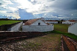
During the colonial era, the region was known as Portuguese Guiana. It was initially a source of valuable exports for Europe, including resins, lumber, vegetable oils, and salted fish. The area was a point of intense international contention, particularly between Portugal and France. To secure Portuguese power, the Fortress of São José de Macapá was constructed.
The dispute over the territory lasted until 1900, when international arbitration in Geneva ruled in favor of Brazil. After being part of the state of Pará, the region became the federal territory of Amapá in 1943. It finally achieved full statehood on October 5, 1988, following the promulgation of the new Brazilian Constitution.
Geography and Climate
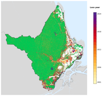
Amapá is characterized by its extraordinary preservation of original vegetation, boasting the lowest rate of forest loss of any Brazilian state (estimated at only 2%). While rainforest dominates, the landscape also includes savannahs, plains, and coastal swamps where salt and fresh water mix, creating a unique habitat for diverse animal species.
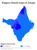
The climate is primarily a Tropical monsoon climate (classified as Am in the Köppen system), which features heavy rainfall for most of the year and a short dry season.
Nature and Conservation
Conservation is a cornerstone of Amapá's identity. Approximately 72% of the state is comprised of protected areas and indigenous territories. A key initiative, the Amapá Biodiversity Corridor, was established in 2003 to integrate the management of these conservation zones.
Two of the most significant sites are the Tumucumaque Mountains National Park, the largest tropical forest park globally, and the Cabo Orange National Park, which protects vital mangrove forests and flooded grasslands that serve as fish nurseries.
Demographics and Society
The population of Amapá is highly urbanized, with 93.7% of residents living in Macapá and Santana. The ethnic composition is diverse, with the majority identifying as Pardo (multiracial) at 65.3%, followed by White (21.4%), Black (11.8%), and Indigenous (1.4%) populations.
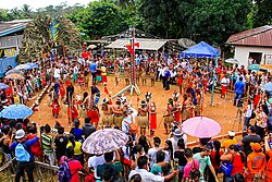
Indigenous heritage remains strong, with tribes such as the Galibi do Oiapoque, Karipuna do Amapá, Palikur, Wayampi, and Galibi Marwono residing in demarcated territories. In terms of education, while Portuguese is the official language, French is taught in all schools due to the proximity of French Guiana, and some residents speak a Creole language known as Lanc-Patuá.
Economy and Infrastructure
Amapá's economy is heavily reliant on the service sector, which accounts for 87.6% of the GDP. However, the industrial sector is significantly influenced by mining; the discovery of manganese in Serra do Navio in 1945 revolutionized the local economy and remains a primary revenue source.
Transport in the state is unique as there are no road connections to other Brazilian states. Travel to Pará requires ferries from Laranjal do Jari or Port Santana. Internally, the BR-156 highway connects Macapá to Oiapoque and links to French Guiana via the Oyapock River Bridge.
| Category | Detail |
|---|---|
| GDP Total | R$ 20.1 billion (US$ 3.7 billion) |
| HDI (2024) | 0.759 (High) |
| Main Exports | Wood (75.5%), Ores (18.7%), Heart of Palm (5.5%) |
| Official Language | Portuguese (French taught in schools) |
| Time Zone | UTC−03:00 (BRT) |
Frequently Asked Questions
What is the most significant natural landmark in Amapá?
The Tumucumaque Mountains National Park is the most significant landmark, as it is the largest tropical forest national park in the world.
How does one travel from Amapá to other Brazilian states?
Since there are no road connections to other states, travelers must use ferries, such as those from Port Santana to Belém or from Laranjal do Jari to Monte Dourado in Pará.
What is the primary economic activity in Amapá?
While the service sector is the largest component of the GDP, manganese mining in Serra do Navio is the state's most important industrial revenue source.
Why is French taught in Amapá schools?
French is taught as a second language in every school due to the state's direct border with French Guiana.
What is the ethnic makeup of the state?
According to the 2022 census, the population is 65.3% Pardo (multiracial), 21.4% White, 11.8% Black, and 1.4% Indigenous.