Altiplano: The Vast High Plateau of the Andes
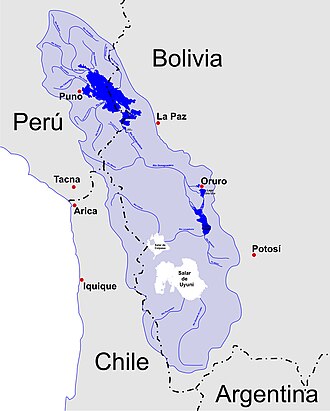
The Altiplano, Spanish for "high plain," is a massive plateau located in west-central South America. Also known as the Collao (from the Quechua and Aymara word Qullaw, meaning "place of the Qulla"), it represents the most extensive high plateau on Earth outside of Tibet. Situated at the widest point of the north-south trending Andes, this region spans across Bolivia, Peru, Chile, and Argentina.
Life on the Altiplano is defined by its extreme elevation and unique geography. While the bulk of the plateau lies within Bolivia, its northern reaches extend into Peru, and its southwestern fringes touch Chile and Argentina. The region is home to several major cities, including El Alto and Oruro in Bolivia, as well as Juliaca and Puno in Peru.
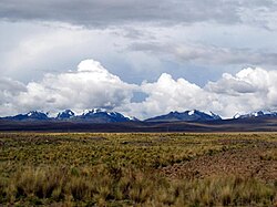
Key Facts
- Average Elevation: Approximately 3,750 to 3,800 meters (12,300 to 12,500 feet).
- Primary Countries: Bolivia, Peru, Chile, and Argentina.
- Largest City: El Alto, Bolivia.
- Notable Water Bodies: Lake Titicaca (largest in South America) and the defunct Lake Poopó.
- Key Economic Drivers: Mining, services, international tourism, and the herding of llamas and vicuñas.
- Population: Approximately 2,850,000 (as of 2012).
Geography and Landscape
The Altiplano is characterized by endorheism, a geological condition where water drains into internal basins rather than flowing into the ocean. This inland drainage system has created a landscape of stark contrasts, from humid northern regions to arid southwestern salt flats, known as salares.
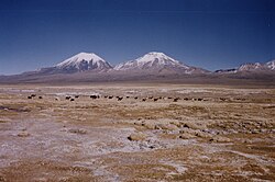
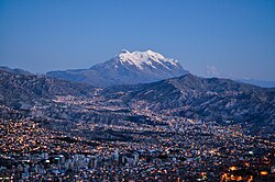
The plateau is flanked by dramatic mountain ranges. To the west, the Central Volcanic Zone features massive active volcanoes, including Parinacota (6,348 m), Ampato (6,288 m), and Licancabur (5,916 m). To the northeast, the Cordillera Real rises with peaks such as Illimani (6,438 m) and Janq'u Uma (6,427 m). This high-altitude environment results in hypoxic air (air with low oxygen levels), to which local communities—including the Qulla, Uros, Quechua, and Aymara—have adapted.
The region's boundaries are further defined by extreme environments: the hyper-arid Atacama Desert lies to the southwest, while the humid Amazon rainforest borders the plateau to the east.
Geological Formation
Scientists have proposed several hypotheses to explain how such a large area of low relief formed at such a high altitude within the Andean orogen (mountain-building zone):
- Crustal Weakness: Pre-existing weaknesses in the Earth's crust may have partitioned tectonic deformation, creating space for the basin.
- Magmatic Activity: Processes rooted in the asthenosphere (the upper mantle) may have contributed to the plateau's uplift.
- Climatic Influence: Climate may have controlled sediment deposition and lubrication of the subducting Nazca Plate, influencing tectonic forces.
- Lithospheric Removal: The convective removal of the dense lower lithosphere may have allowed the region to "float" higher isostatically.
During the Pleistocene epoch, the Altiplano was covered by vast pluvial lakes. Today, the remnants of these ancient lakes are Lake Titicaca and the Salar de Uyuni (also known as Salar de Tunupa) and Salar de Coipasa, which are now expansive dry salt flats.
Climate and Environment
The climate of the Altiplano is cold and dry, with significant daily temperature swings. It is generally cooler than the tierra fría (cold land) but warmer than the tierra helada (frozen land), which typically begins around 4,500 meters. In local contexts, this climate zone is often referred to as puna or páramos.
Annual temperatures vary based on location, ranging from 3°C (37°F) near the western mountains to 12°C (54°F) near Lake Titicaca. Rainfall is similarly varied, with less than 200 mm (8 in) in the southwest and over 800 mm (31 in) near Lake Titicaca. The rainy season typically occurs between December and March, while the rest of the year is sunny, windy, and dry.
Lake Titicaca plays a critical role as a thermoregulator. Because of its large thermal mass, the lake absorbs heat during the day and releases it at night, moderating the temperature for surrounding riparian communities and supporting local agriculture.
| Feature | Details |
|---|---|
| Average Elevation | 3,750 m (12,300 ft) |
| Climate Type | Cold, semi-arid to arid |
| Key Water Bodies | Lake Titicaca, Salar de Uyuni |
| Major Volcanic Peaks | Parinacota, Ampato, Licancabur |
| Historical Cultures | Chiripa, Tiawanaku, Inca Empire |
Frequently Asked Questions
What is the Altiplano?
The Altiplano is a high-altitude plateau in west-central South America, primarily located in Bolivia and Peru, with extensions into Chile and Argentina. It is the largest high plateau on Earth outside of Tibet.
Why is the air hypoxic in the Altiplano?
The air is hypoxic because of the region's extreme elevation, which averages around 3,750 to 3,800 meters. At these heights, the atmospheric pressure is lower, resulting in less available oxygen.
What happened to Lake Poopó?
Lake Poopó, which was once the second-largest lake in Bolivia, completely dried up by December 2015 and was declared defunct. It remains unclear if the lake can be restored.
How does Lake Titicaca affect the local climate?
Lake Titicaca acts as a thermoregulator, absorbing heat during the day and releasing it at night. This reduces daily and seasonal temperature extremes, creating milder microclimates that support human settlement and farming.
Which ancient civilizations lived in the Altiplano?
The region was home to several pre-Columbian cultures, most notably the Chiripa, the Tiawanaku, and the Inca Empire, before the Spanish conquest in the 16th century.