Air Masses: The Drivers of Global Weather and Climate
In the field of meteorology, an air mass is a massive volume of air defined by its specific temperature and humidity levels. These enormous bodies of air can cover hundreds or even thousands of square miles, and they possess a unique ability to adapt to the characteristics of the surface beneath them. By understanding how these masses form, move, and interact, we can better predict the complex weather patterns that shape our world.
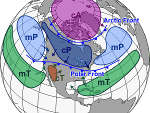
Different air masses, which affect North America as well as other continents, tend to be separated by frontal boundaries. These boundaries, known as weather fronts, occur when two masses of air with different densities—caused by variations in temperature or moisture—meet.
Key Facts
- Air masses are classified by their source region (latitude and surface type) and their moisture content.
- The Bergeron classification uses a three-letter system to denote moisture, source, and stability.
- Continental air masses are dry, while maritime air masses are moist.
- Fronts are the primary cause of most meteorological phenomena.
- Air masses can be modified by the vegetation or water bodies they travel over.
Classification and the Bergeron System
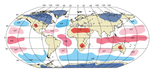
The most widely accepted method for identifying these air volumes is the Bergeron classification. This system utilizes a three-letter notation to provide a precise description of an air mass's properties.
The Three-Letter Notation
The first letter of the code describes the moisture properties:
- c: Continental (dry)
- m: Maritime (moist)
The second letter identifies the source region:
- T: Tropical
- P: Polar
- A: Arctic or Antarctic
- M: Monsoon
- E: Equatorial
- S: Adiabatically drying and warming air (formed by significant downward atmospheric motion)
For example, an air mass originating over the desert southwest of the United States during summer might be labeled cT, while one from northern Siberia in winter would be cA.
Stability and Modification
A third letter can be added to indicate the stability of the air mass relative to the surface below it. A k indicates the air mass is colder than the surface, while a w indicates it is warmer. For instance, a polar air mass blowing over the warm Gulf Stream might be denoted as cPk.
Meteorologists also use specific conventions to show how air masses change or layer. A notation like cA-mPk indicates an Arctic air mass that has transformed into a maritime polar air mass. If one air mass is riding over another, such as polar air being overrunning by air from the Gulf of Mexico, it may be written as mT/cP.
Characteristics of Major Air Masses
Air masses vary significantly depending on whether they develop over land or water and their latitude of origin.
Tropical and Equatorial Air
Tropical and equatorial air masses are characterized by high temperatures. Because hot air rises, these masses often feature lower pressure. Maritime tropical (mT) air masses, sometimes called trade air masses, are moist and can affect the United States via the Caribbean Sea, the southern Gulf of Mexico, or the tropical Atlantic. In contrast, Continental tropical (cT) air masses are extremely hot and dry, often originating from low-latitude deserts like the Sahara, the Arabian Peninsula, or the Southwestern United States.
Polar and Arctic Air
Cold air masses are categorized as polar or arctic. Arctic air is exceptionally cold, developing over ice and snow-covered ground. Polar air masses develop over higher latitudes and are generally very stable. While polar air over the ocean is stable, it can lose that stability and gain moisture as it moves over warmer waters.
Additionally, superior air masses are dry and typically reside over maritime tropical air masses, forming a warmer, drier layer known as a trade wind inversion.
Movement, Fronts, and Weather Modification
When air masses collide, they create weather fronts. These boundaries are the principal cause of most weather events. The type of front determines the resulting weather:
- Cold fronts: Often feature narrow bands of thunderstorms and severe weather. They generally move from west to east and move faster than warm fronts due to their higher density.
- Warm fronts: Usually preceded by fog and stratiform precipitation. They tend to move poleward.
- Stationary fronts: Occur when the density contrast vanishes, creating a shearline—a boundary separating regions of different wind velocities.
The Impact of Surface Modification
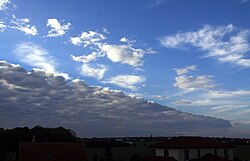
An air mass does not remain static; it is constantly modified by the surface it traverses. Vegetation, such as forests, can add moisture to the air, while warm water bodies can rapidly change an air mass's character within just 35 to 40 kilometers.
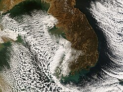
A notable example is lake-effect snow. When cold air moves across a relatively warm large body of water, the temperature difference (often exceeding 13°C or 23°F) causes warmth and moisture to rise. This moisture condenses into vertically oriented clouds, creating intense, localized snow bands.
Summary of Air Mass Types
| Notation | Type | Primary Characteristics |
|---|---|---|
| mT | Maritime Tropical | Warm and moist |
| cT | Continental Tropical | Hot and dry |
| cP | Continental Polar | Cold and dry |
| mP | Maritime Polar | Cold and moist |
| cA | Arctic | Extremely cold |
Frequently Asked Questions
What is the difference between continental and maritime air masses?
The primary difference is moisture content. Continental air masses originate over land and are dry, whereas maritime air masses originate over oceans and are moist.
How are air masses classified?
They are classified using the Bergeron system, which uses a three-letter code to describe moisture (c or m), the source region (T, P, A, M, E, or S), and sometimes stability (k or w).
What causes a weather front?
A weather front is created when two air masses of different densities—due to differences in temperature or moisture—meet and create a boundary.
What is lake-effect snow?
Lake-effect snow occurs when cold air moves over a warmer large body of water. The temperature difference causes moisture to rise and condense into clouds, resulting in heavy, localized snow showers.
Why do cold fronts move faster than warm fronts?
Cold fronts move faster because the air in their wake has a greater density compared to the air they are displacing.