Zonda Wind: The Powerful Foehn Effect of the Andes
In the shadow of the towering Andes mountains in Argentina, a unique meteorological phenomenon known as the Zonda wind (Spanish: viento zonda) shapes the environment and the lives of those living in the region. This wind is a regional variation of a foehn wind—a dry, warm, down-slope wind that occurs on the lee side of a mountain range.
Key Facts
- Origin: Polar maritime air that descends from the Andes crest.
- Peak Velocity: Can exceed 240 km/h (150 mph).
- Primary Regions: Most impactful in La Rioja, San Juan, and northern Mendoza.
- Seasonal Peak: Occurs in 90% of cases between May and November.
- Dual Nature: Causes snow at high altitudes (viento blanco) but is hot and dry in lowlands.
How the Zonda Wind Forms
The Zonda is driven by the northeastward movement of polar fronts. The process begins with polar maritime air hitting the Andes, which reach heights of approximately 6,000 meters (20,000 ft) above sea level. As the air is forced over the crest and descends the eastern slope, it warms and loses moisture, resulting in a hot, dry wind that often carries dust into the lowlands.
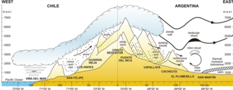
Interestingly, while the Zonda is dry at lower elevations, it is the primary mechanism for snow precipitation in the high-altitude chains. At these heights, the wind is known as viento blanco (white wind) and can reach speeds over 200 km/h. Rather than depleting snow, this process is vital for the arid region, as it facilitates the buildup of winter snow cover and the accumulation of the area's scarce local glaciers.
Occurrence and Regional Impact
The effects of the Zonda are most pronounced in the provinces of La Rioja, San Juan, and northern Mendoza. In these areas, the mountain barrier of the Andes is highest, creating a more dramatic pressure change. Conversely, to the north, the Puna plateau tends to dissipate these winds.
Data collected between 1967 and 1976 indicates that the Zonda typically begins in the afternoon, specifically between 12 p.m. and 6 p.m. A single event usually lasts between 1 to 12 hours, though intermittent winds can persist for 2 or 3 days. The phenomenon is typically countered by the viento sur, which consists of cold air masses moving northwestward.
| Feature | Details |
|---|---|
| Maximum Speed | Over 240 km/h (150 mph) |
| Peak Season | May to November |
| Typical Start Time | 12:00 p.m. to 6:00 p.m. |
| High-Altitude Form | Viento blanco (snow-bearing) |
| Low-Altitude Form | Hot, dry, and dusty |
Alternative Meanings and Usage
Beyond the Andean foehn wind, the term "zonda" is used in other contexts within Argentina. In the Pampas region, it describes a hot, humid north wind (also called the sondo) that arrives ahead of an eastward-moving depression and precedes the pampero wind.
The name has also extended into geography and culture, referring to the Zonda Department in the province of San Juan, as well as the Pagani Zonda, a high-performance sports car named after the wind.
Frequently Asked Questions
What is the difference between Zonda and viento blanco?
The Zonda is the hot, dry wind felt in the lowlands after the air descends the mountains. Viento blanco is the same atmospheric movement but occurring at high altitudes, where it brings heavy snow and high wind speeds.
When is the Zonda wind most likely to occur?
Statistically, 90% of Zonda events take place between May and November, typically starting in the afternoon between 12 p.m. and 6 p.m.
How fast can the Zonda wind blow?
The wind is extremely powerful and can exceed velocities of 240 km/h (150 mph).
Which Argentine provinces are most affected by the Zonda?
The most impressive effects are seen in San Juan, La Rioja, and northern Mendoza due to the height of the Andean barrier in those regions.
What eventually stops a Zonda wind event?
The Zonda is usually countered by the arrival of the viento sur, which brings cold air masses moving toward the northwest.