Zambia National Monuments: A Journey Through Prehistoric and Colonial History
Zambia possesses a rich and diverse heritage that spans millennia, from the earliest footprints of human habitation to the architectural remnants of the colonial era and the triumphant markers of independence. These sites, declared national monuments by the National Heritage Conservation Commission (NHCC), serve as vital links to the country's cultural, political, and natural evolution.
Key Facts
- Prehistoric Reach: Some rock paintings, such as those at Nachikufu Cave, date back approximately 18,000 years.
- Colonial Footprints: Monuments include the first colonial settlement at Old Drift and the oldest surviving church, Niamkolo Church (1895).
- Independence Legacy: Several sites commemorate the life and leadership of Dr. Kenneth David Kaunda, the first President of Zambia.
- Natural Wonders: The country protects geological marvels like the 50,000-year-old Chirundu Fossil Forest and the massive Lunsemfwa Wonder Gorge.
Prehistoric Monuments and Archaeological Sites
Zambia's landscape is dotted with evidence of early human existence, ranging from the Middle Pleistocene (a geological epoch from about 770,000 to 126,000 years ago) to the Iron Age. These sites provide critical data on the migration and cultural development of early peoples in Southern Africa.
Rock Art and Shelters
The region is renowned for its rock paintings and engravings. Notable sites include the 18,000-year-old paintings at Nachikufu Cave in Mpika District and the 12,000-year-old art at Nsalu Cave in Serenje District. Other significant shelters include the Kalemba Rock Shelter in Chadiza and the Nyambwezu Rock Shelter, which features art roughly 3,000 years old.
Early Settlements and Tool Sites
Archaeological excavations have revealed complex early societies. The Kalundu Mound in Kalomo marks a village occupied between the ninth and twelfth centuries, while the Maramba Quarry Site in Livingstone represents the first stratified site of the Middle Pleistocene Hope Fountain Culture in Southern Africa. In Samfya, the Kasamba Stream Grinding Grooves highlight Iron Age industrial activity where iron implements and axes were sharpened.
Monuments of the Colonial Era
The colonial period left a distinct mark on Zambia's geography, characterized by administrative centers, military forts, and religious missions.
Administrative and Military Sites
Livingstone served as the capital of North-Western and Northern Rhodesia, housing the Old Government House (1907-1935) and the first colonial settlement at Old Drift. Military history is preserved through various forts, including Fort Elwes on the Congo Pedicle border and Fort Monze, one of the earliest colonial police posts from the 1890s.
Commemorative and Religious Landmarks
The Livingstone Memorial in Chitambo District marks where David Livingstone died in 1873. In Mpulungu, the Niamkolo Church stands as the oldest surviving church building in the country, dating back to 1895. Additionally, the "The Good News" Monument in Mbala commemorates the 1884 launch of the London Missionary Society's steamship.
The Path to Independence
The struggle for sovereignty is immortalized through the preservation of homes and offices associated with the leaders of the independence movement, particularly Dr. Kenneth David Kaunda.
- Bwacha House: Where Dr. Kaunda was elected President of the Zambia African National Congress on March 8, 1958.
- Freedom House: The site where the United National Independence Party (UNIP) launched its 1962 manifesto.
- Lubwa House: The residence of Dr. Kaunda in Chinsali, where he served as headmaster of Lubwa Upper Primary School starting in 1945.
- Kabompo House: The location where Dr. Kaunda was restricted by colonial authorities from March to July 1959.
Other Historic and Industrial Landmarks
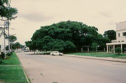
Beyond politics and prehistory, Zambia preserves sites of social and industrial significance. The Big Tree in Kabwe, a fig tree with a 50m wide canopy, served as a historic meeting place for the township.
Industrial milestones are marked by the Collier Monument in Luanshya and the Moir and Bell Monument in Mufulira, both commemorating the discovery of copper ore. Other sites include the Dag Hammarskjöld Crash Site Memorial in Ndola and the Football Heroes Burial Site in Lusaka, which honors the victims of the 1993 Gabon Air Disaster.
Natural Monuments
Zambia's natural monuments showcase the raw power of geology and the beauty of its biodiversity. From the source of the Zambezi River in Mwinilunga to the massive Kalambo Falls in Mbala, these sites are of global scientific importance.
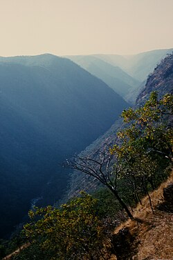
One of the most striking features is the Lunsemfwa Wonder Gorge, where the river cuts a 500m deep gash through the Muchinga Escarpment.
Other notable natural sites include the 50,000-year-old Chirundu Fossil Forest and various sunken lakes, such as Lake Kashiba, which reaches depths of 100 meters.
| Category | Notable Site | Location | Significance |
|---|---|---|---|
| Prehistoric | Nachikufu Cave | Mpika District | 18,000-year-old rock paintings |
| Colonial | Niamkolo Church | Mpulungu | Oldest surviving church (1895) |
| Independence | Bwacha House | Kabwe | Election of Dr. K.D. Kaunda (1958) |
| Natural | Wonder Gorge | Mkushi District | 500m deep river gorge |
| Industrial | Collier Monument | Luanshya | 1902 copper discovery |
Frequently Asked Questions
What is the oldest prehistoric site mentioned?
The Nachikufu Cave in Mpika District contains rock paintings that are approximately 18,000 years old.
Which site commemorates the end of World War I in Zambia?
The Chambeshi Monument, located near the north end of Chambeshi Bridge, marks the spot where German East African forces agreed to a cease-fire on November 14, 1918.
Where can one find evidence of the early copper mining industry?
The Collier Monument in Luanshya and the Moir and Bell Monument in Mufulira commemorate the discovery of copper-bearing ore in 1902 and 1923, respectively.
What is the significance of the Chirundu Fossil Forest?
The Chirundu Fossil Forest contains fossilized trees that are approximately 50,000 years old, providing a glimpse into the region's ancient botanical history.
Which monuments are associated with Dr. Kenneth David Kaunda?
Several sites are associated with Dr. Kaunda, including Bwacha House, Chilenje House 394, Kabompo House, and the Lubwa House in Chinsali.