Winnigstedt and Mattierzoll: A History of Borders and Transit
Nestled in a region defined by its unique geography, the village of Winnigstedt occupies a strategic position north of the Großes Bruch marshland and west of the Magdeburg Börde, an area renowned for its high soil quality. To the south, the village shares a direct border with Hessen in the state of Saxony-Anhalt.
The municipal area is composed of Winnigstedt proper and the southern quarter of Mattierzoll. For centuries, Mattierzoll served as a vital toll station on the road connecting Wolfenbüttel to Halberstadt, a route known as the Hessendamm and currently designated as Bundesstrasse No. 79.
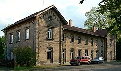
The Strategic Importance of the Hessendamm
The location of Mattierzoll was historically significant because it provided a causeway—a raised road across wet ground—allowing travelers to navigate the surrounding wetlands. This path linked the Brunswick-Lüneburg lands in the north with the territory of the Prince-Bishops of Halberstadt to the south.
Following World War II, the geopolitical landscape shifted dramatically. The area became a frontier bordering the Soviet occupation zone, which later became the German Democratic Republic (GDR). Consequently, the road was closed to traffic until the Peaceful Revolution of 1989. Today, a preserved watchtower stands along the road as a physical reminder of the former Inner German border.
The Rise and Fall of the Rail Hub
Starting in 1902, Mattierzoll evolved into a significant railroad junction. It served as the meeting point for three distinct lines:
- The Jerxheim–Börßum railway.
- The line connecting Braunschweig to Schöningen.
- A private railway leading to Heudeber.
The Cold War once again impacted local infrastructure; by the 1950s, railway service to Heudeber in East Germany was discontinued. Despite this, the border station continued to function as a rail hub between the Braunschweig-Schöningen line and the railway running from Helmstedt to Holzminden. By the late 1970s, however, all these rail lines had been dismantled.
Key Facts
- Geography: Located north of Großes Bruch and west of Magdeburg Börde.
- Infrastructure: The Hessendamm (Bundesstrasse 79) served as a historic causeway through wetlands.
- Border History: Mattierzoll was a point on the Inner German border until 1989.
- Rail History: A major junction from 1902 until the dismantling of lines in the late 1970s.
| Era | Primary Transit Role | Status/Outcome |
|---|---|---|
| Pre-WWII | Toll station and causeway | Connected Brunswick-Lüneburg to Halberstadt |
| 1902 - 1970s | Railroad junction | Lines dismantled by late 1970s |
| Post-WWII - 1989 | Inner German border | Road closed until Peaceful Revolution |
Frequently Asked Questions
What is the significance of the Magdeburg Börde in this region?
The Magdeburg Börde is the area to the west of Winnigstedt, characterized by its high soil quality, which is a defining geographical feature of the surrounding landscape.
What was the purpose of the Hessendamm?
The Hessendamm served as a causeway that allowed travelers to cross the Großes Bruch wetlands, linking the territories of Brunswick-Lüneburg and the Prince-Bishops of Halberstadt.
Why was the road at Mattierzoll closed for several decades?
The road was closed after World War II because it bordered the Soviet occupation zone (later the GDR), making it part of the Inner German border.
Which railway lines once met at the Mattierzoll junction?
The junction connected the Jerxheim–Börßum railway, the Braunschweig-Schöningen line, and a private railway to Heudeber.
Is there any remaining evidence of the Inner German border in the area?
Yes, a preserved watchtower remains on the road to mark the location of the former border.