White Mountain Summit Climbing Routes and Access
Reaching the summit of one of California's most prominent peaks offers a variety of experiences, ranging from accessible dirt roads to strenuous ridge climbs. While the peak is often considered one of the easiest fourteeners (mountains exceeding 14,000 feet in elevation) in the state, the high altitude ensures that every ascent remains a challenge for hikers.
The Jeep Road and Open Gate Access
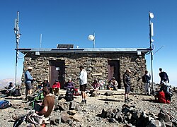
The most accessible route to the summit station is via a winding dirt road, which is typically cleared of snow from late June through September. Under normal conditions, access is restricted to hikers by a locked gate located approximately two miles before Barcroft Station. However, the White Mountain Research Station generally opens this gate, situated at 11,680 feet (3,560 m), once per year, usually on a Sunday during the summer.
For those hiking from the gate, the round trip covers about 14 miles (23 km). While the net vertical gain is less than 2,600 feet (800 m), the trail includes two dips of roughly 250 feet each, bringing the total cumulative elevation gain for the round trip to over 3,500 feet. Utilizing the open gate day significantly reduces the effort, shaving approximately 4 miles (6 km) and 790 feet (240 m) of gain off the journey. Due to the terrain, this route is also a popular choice for mountain bikers.
Alternative Ascent Routes
For those seeking a more rigorous experience than the jeep road, several alternative routes provide varying levels of difficulty and scenery.
The Western Ridge
One of the most strenuous options is the western ridge. This route begins at the end of a rough road and involves a steep climb of 8,150 feet (2,500 m) directly out of Owens Valley.
Wyman Canyon
Approaching from the east via Wyman Canyon from the Deep Springs Valley offers a different landscape. This route climbs 7,100 feet to the summit and is advantageous for those needing hydration, as there are many water sources within the first 12 miles.
Leidy Canyon and Perry Aiken Flat
A nontechnical alternative to the jeep road involves driving as far as possible up Leidy Canyon from Fish Lake Valley. From there, hikers can follow a graded cattle trail up a broad ridge to Perry Aiken Flat. From the flats, hikers can traverse south into the cirque (a bowl-shaped valley) of the North Fork, North Branch of Perry Aiken Creek. A moderate scramble up the ridge between the North Branch and the main North Fork cirque leads to the easier upper slopes of the peak.
The Northern Approach
The peak is rarely approached from the north, as the terrain is guarded by a narrow arête—a sharp, knife-edge ridge—making it the least favorable route for most.
Key Facts
- Easiest Route: The jeep road is considered the simplest way to reach the summit.
- Open Gate Day: Occurs typically once a year on a summer Sunday at 11,680 feet.
- Maximum Gain: The Western Ridge requires an 8,150-foot climb.
- Water Availability: Wyman Canyon provides multiple water sources in the first 12 miles.
- Technicality: No technical climbing skills are required, though high altitude remains a significant factor.
| Route | Starting Point | Elevation Gain | Difficulty/Feature |
|---|---|---|---|
| Jeep Road (Gate) | Locked Gate | >3,500 ft (Round Trip) | Easy / Popular for biking |
| Western Ridge | Owens Valley | 8,150 ft | Strenuous / Steep |
| Wyman Canyon | Deep Springs Valley | 7,100 ft | Moderate / Good water access |
| Leidy Canyon | Fish Lake Valley | Variable | Nontechnical / Cattle trail |
| Northern Route | North Side | Variable | Difficult / Narrow arête |
Frequently Asked Questions
When is the best time to visit the summit?
The winding dirt road to the summit station is usually cleared of snow between late June and September, making this the primary window for access.
What is an "open gate day"?
It is a day, typically a Sunday in the summer, when the White Mountain Research Station opens the locked gate at 11,680 feet, reducing the hiking distance and elevation gain for visitors.
Do I need technical climbing gear to reach the peak?
No, the peak does not require technical climbing skills, although the high altitude makes the hike challenging for all visitors.
Which route is best for those needing water?
The route up Wyman Canyon from the Deep Springs Valley is recommended, as it features many water sources within the first 12 miles of the climb.
Why is the northern approach avoided?
The northern side is rarely used because it is guarded by a narrow arête, or knife-edge ridge, which is more difficult to navigate.