Western Sahara Border History: From Colonialism to Conflict
The modern borders of Western Sahara are the result of a complex legacy of European imperialism, shifting treaties, and ongoing geopolitical struggles. The region's current status is rooted in the late 19th-century competition for African territory, which set the stage for decades of diplomatic and military tension between Spain, France, Morocco, and Mauritania.
The Colonial Foundations
The origins of these borders lie in the Scramble for Africa, a period of intense competition among European powers during the late 1800s. This era culminated in the Berlin Conference of 1884, where European nations established the rules for territorial claims. Following this, Spain declared a protectorate over the north-west African coast between Cape Bojador and Ras Nouadhibou (Cape Blanco), formally establishing the Rio de Oro colony the following year.
Between 1900 and 1912, a series of treaties between France and Spain refined these boundaries. A 1900 treaty defined the border between Rio de Oro and French West Africa, while a 1904 agreement extended this boundary north to the Algerian tripoint and west along the 27°40'N parallel. This specific line created the Saguia el-Hamra territory and remains the modern boundary between Morocco and Western Sahara.
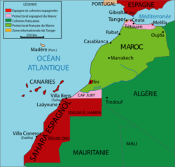
By 1912, further agreements established a French protectorate over most of Morocco, while Spain retained several areas: the Mediterranean littoral (Spanish Morocco), the exclave of Ifni, and the Cape Juby/Tarfaya Strip.
The Transition to Spanish West Africa
From 1946 to 1958, Spain consolidated its holdings—including Spanish Morocco, the Tarfaya Strip, Ifni, Rio de Oro, and Saguia el-Hamra—into a single entity known as Spanish West Africa. However, the geopolitical landscape shifted rapidly in 1956 when Morocco gained independence from France.
Driven by the vision of a "Greater Morocco," the newly independent state claimed all of Spanish West Africa. In response to these pressures and shifting colonial priorities, Spain merged Rio de Oro and Saguia el-Hamra into Spanish Sahara in 1958. That same year, Spain ceded the Tarfaya Strip back to Morocco, and in 1969, it ceded Ifni following a failed Moroccan attempt to seize the region by force in 1957.
The Struggle for Independence and the Green March
As Spain's presence waned, multiple parties claimed the remaining Spanish Sahara. Morocco and Mauritania (which gained independence in 1960) both asserted territorial claims. Simultaneously, Saharawi nationalists formed the Polisario, a movement seeking full independence for the region as Western Sahara, initiating a guerrilla campaign.
In October 1975, the International Court of Justice ruled that neither Morocco nor Mauritania had claims strong enough to justify annexation, suggesting instead that the Saharawi people should determine their own future. Morocco responded by organizing the Green March in November 1975, where thousands of soldiers and nationalists crossed the border into Spanish Sahara.
With dictator Francisco Franco on his deathbed and a desire to avoid a prolonged colonial war, Spain signed a treaty splitting Spanish Sahara between Morocco and Mauritania, with Morocco receiving roughly two-thirds of the territory. Morocco subsequently absorbed its section, effectively erasing the de facto border.
The Berm and the Modern Stalemate
The Polisario declared the Saharawi Arab Democratic Republic based on the original boundaries of Spanish Sahara, leading to a protracted war against Morocco and Mauritania. Mauritania eventually withdrew from the conflict in 1979, and Morocco annexed the remaining territory.
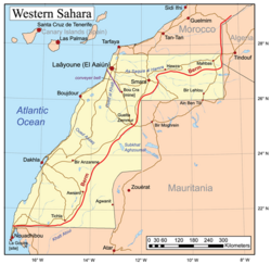
To secure its control and block Polisario advances, Morocco constructed a series of elaborate walls, known as berms, completing the Moroccan Western Sahara Wall in 1987. A ceasefire was finally signed in 1991, leaving the territory divided: Morocco controls the western areas (approximately 80% of the region), while the Polisario controls the east.
Key Facts
- Berlin Conference (1884): The event that established the rules for European territorial claims in Africa.
- 27°40'N Parallel: The line established in 1904 that forms the modern Morocco-Western Sahara boundary.
- Green March (1975): A mass mobilization by Morocco to forcibly claim Spanish Sahara.
- The Berm: A military wall completed in 1987 that divides the territory between Moroccan and Polisario control.
- Territorial Split: Morocco currently controls roughly 80% of Western Sahara.
| Period/Event | Territorial Status | Key Outcome |
|---|---|---|
| Late 19th Century | Rio de Oro Colony | Spanish protectorate established. |
| 1946–1958 | Spanish West Africa | Consolidation of Spanish holdings. |
| 1958 | Spanish Sahara | Merge of Rio de Oro and Saguia el-Hamra. |
| 1975 | Green March | Spain cedes territory to Morocco and Mauritania. |
| 1991–Present | Ceasefire/Berm | Morocco controls west; Polisario controls east. |
Frequently Asked Questions
What was the purpose of the Berlin Conference of 1884?
The Berlin Conference was held to regulate European colonization and trade in Africa, allowing European powers to agree upon their territorial claims and rules of engagement to avoid conflict among themselves.
What is the Polisario?
The Polisario is a nationalist movement formed by Saharawi people seeking the independence of Western Sahara from Moroccan and Mauritanian control.
What was the significance of the Green March?
The Green March was a 1975 military and civilian mobilization by Morocco that forcibly crossed the border into Spanish Sahara, pressuring Spain to relinquish its colonial control.
What is the "berm" in Western Sahara?
The berm is a series of elaborate military walls built by Morocco in the 1980s to control the territory and prevent Polisario forces from entering the western portion of the region.
How did the International Court of Justice rule in 1975?
The court ruled that the claims made by Morocco and Mauritania were not strong enough to justify annexation and that the Saharawi people should be allowed to determine their own political future.