Waipahu: From Sugarcane Plantation to Vibrant Hawaiian Community
Nestled in the ʻEwa District on the island of Oʻahu, Waipahu is a community with a deep-rooted history that stretches from the era of massive sugarcane plantations to its modern status as a bustling census-designated place (CDP). Located in Honolulu County, this area serves as a vital link between the historic agricultural past of Hawaiʻi and its contemporary urban landscape.
Today, Waipahu is a diverse residential hub with a population of 43,485 as of the 2020 census. While its economy has shifted away from the sugar mills that once defined its skyline, the spirit of its multiethnic heritage remains visible in its culture, landmarks, and people.
Key Facts
- Location: ʻEwa District, Oʻahu, Honolulu County, Hawaiʻi.
- Population: 43,485 (2020 Census).
- Historical Industry: Sugarcane production via the Oahu Sugar Company.
- Major Landmark: Hawaiʻi Plantation Village, a living history museum.
- Geography: Spans three historic ahupuaʻa (traditional land divisions): Waipiʻo, Waikele, and Hōʻaeʻae.
The Legacy of the Oahu Sugar Company
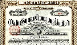
The history of Waipahu is inextricably linked to the Oahu Sugar Company, which was incorporated in 1897. The company established its sugar mill in Waipahu, creating a massive industrial operation that relied on a diverse workforce of laborers brought from across the globe.
In its early years, the plantation workforce was a melting pot of nationalities. The company imported laborers from the Philippines, Japan, China, Portugal, and Norway. Interestingly, very few of the early laborers working for the Oahu Sugar Co. were Native Hawaiian. The workforce was organized through a strict Plantation System, where workers were often identified by numbers inscribed on metal discs. For example, numbers 1 through 899 were assigned to Japanese aliens, while the 2000 series identified Portuguese laborers.
Economic disparities were present within this system. While Chinese laborers generally earned the highest average monthly salary of approximately $15.00, Filipino immigrants—who were the least expensive to import—earned an average of less than $10.00 per month. Despite these hardships, the company provided some avenues for advancement, such as a continuation school opened in 1932, which offered day and evening courses to help workers improve their knowledge for better job opportunities.
War and Transition
Waipahu's history was also touched by global conflict. During the attack on Pearl Harbor on December 7, 1941, Imperial Japanese Navy planes fired upon the Waipahu sugar mill, resulting in one civilian death and seven injuries. The plantation era eventually drew to a close when Amfac acquired the company in 1961, and operations finally ceased following the 1995 harvest.
Geography and Landscape
Waipahu is situated along the northern shores of both Middle Loch and West Loch of Pearl Harbor. The town is bisected by major transit routes, including Interstate H-1 and Farrington Highway (Hawaii Route 90). The landscape is characterized by a gentle elevation change of roughly 140 feet from the H-1 side down to sea level.
The area is also defined by its natural waterways, such as the Waikele and Kapakahi Streams. The Waikele Stream flows past the Hawaiʻi Plantation Village and into the Pouhala Marsh Wildlife Sanctuary, a critical habitat for several endemic bird species that are found only in Hawaiʻi.
Cultural Preservation: Hawaiʻi Plantation Village
To honor its complex past, the City and County of Honolulu and the State of Hawaiʻi established the Waipahu Cultural and Garden Park in 1973. Now known as Hawaiʻi Plantation Village, this living history museum opened in 1992. It features original structures and replica homes that showcase the lifestyles of the various ethnic groups who migrated to Hawaiʻi to work on plantations between the mid-1800s and the 1940s.
Community Demographics and Modern Life
Modern Waipahu is a highly urbanized area with a rich ethnic tapestry. According to the 2020 census, the community is predominantly Asian (72.2%), with the largest ancestral group being Filipino (71.1%), followed by Japanese (10.5%) and Native Hawaiian (10.2%).
| Census Year | Total Population | Growth Rate |
|---|---|---|
| 1970 | 24,150 | — |
| 1980 | 29,139 | 20.7% |
| 1990 | 31,435 | 7.9% |
| 2000 | 33,108 | 5.3% |
| 2010 | 38,216 | 15.4% |
| 2020 | 43,485 | 13.8% |
The community also boasts a strong connection to athletics. The area was home to the 2008 Little League World Series champions from Waipi'o Little League. Additionally, the historic athletic field, once the community center for the plantation, was renamed Hans L'Orange Field and continues to host baseball, including games for Hawaii Pacific University's Sea Warriors.
Frequently Asked Questions
What is the main historical attraction in Waipahu?
The primary historical attraction is the Hawaiʻi Plantation Village, an outdoor living history museum that displays the homes and lifestyles of the multiethnic plantation workers who shaped the region's history.
What was the primary industry in Waipahu historically?
Waipahu was historically a sugarcane plantation town, driven largely by the operations of the Oahu Sugar Company.
Which ethnic groups make up the majority of Waipahu's population?
The population is predominantly Asian, with Filipino, Japanese, and Chinese ancestries being among the most prominent, alongside significant Native Hawaiian and Samoan communities.
Is Waipahu a rural or urban area?
According to the 2020 census, 100% of Waipahu residents live in urban areas.
What are the traditional land divisions in Waipahu?
The town spans across three historic Native Hawaiian land divisions, known as ahupuaʻa: Waipiʻo, Waikele, and Hōʻaeʻae.