University Avenue: The Historic Link Between Minneapolis and Saint Paul
University Avenue serves as a vital artery connecting the two largest cities in Minnesota. More than just a thoroughfare, it is a corridor rich with historical shifts, architectural landmarks, and a legacy of transit that has evolved from early streetcars to modern light rail.
The Evolution of the Route
The geography of University Avenue was not always as it is today. Originally, the road ran several blocks north of its current position, creating a direct path between the University of Minnesota campus in Minneapolis and Hamline University in Saint Paul. This connection is what gave the avenue its name.
The route changed when the construction of the Minnesota Transfer Railway yards blocked the original path. Consequently, the street was shifted one-half mile south on the Saint Paul side to a road then known as Melrose Avenue. The original path was subsequently renamed Minnehaha Avenue, a name it still carries today.
Landmarks and Local Geography
As the road traverses the Twin Cities, it passes through several notable areas, including the Midway region and Frogtown (officially known as the Thomas-Dale neighborhood) in Saint Paul.
One of the most unique points along the route is the site of Hubbard Broadcasting and its flagship stations, KSTP-AM-FM-TV. Located precisely on the border of Minneapolis and Saint Paul, the sidewalk at the KSTP studios sits directly on the city and county line. This location was historically chosen because it was one of the highest points in the area, making it an ideal spot for a radio transmitter.
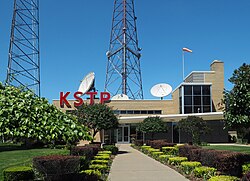
While an antenna structure remains at the KSTP site, it is now used for microwave links. Most Twin Cities stations, including KSTP, have moved their broadcasting operations to the KMSP Tower or the Telefarm installation in Shoreview, Minnesota.
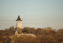
Just a few blocks away in the Prospect Park neighborhood of Minneapolis stands another local landmark: the "Witch's Hat" water tower.
Transportation and Infrastructure
University Avenue has long been a hub for intercity transit. In 1890, the first interurban streetcar link between Minneapolis and Saint Paul utilized University Avenue and Washington Avenue. Today, this legacy continues with the METRO Green Line, a light rail system that connects the two downtowns and the University of Minnesota along a similar route.
From a regulatory and administrative standpoint, the road is managed as several different designations:
- Saint Paul: Carries Ramsey County Road 34.
- Minneapolis: Carries Hennepin County Road 36 up to the I-35W junction.
- North/West of Central Avenue: Carries Minnesota State Highway 47 until the US 10 junction, after which it becomes Anoka County Road 51.
| Location/Segment | Road Designation |
|---|---|
| Saint Paul | Ramsey County Road 34 |
| Minneapolis (to I-35W) | Hennepin County Road 36 |
| West/North of Central Ave (to US 10) | Minnesota State Highway 47 |
| Beyond US 10 Junction | Anoka County Road 51 |
Key Facts
- University Avenue was renamed from Melrose Avenue in Saint Paul after the original route became Minnehaha Avenue.
- The KSTP studios are located exactly on the Minneapolis/Saint Paul city and county line.
- The "Witch's Hat" water tower is a prominent landmark in the Prospect Park neighborhood.
- The METRO Green Line light rail follows a route similar to the 1890 interurban streetcar.
- The road transitions through four different county and state designations across the region.
Frequently Asked Questions
Why was University Avenue moved?
The street was moved one-half mile south on the Saint Paul side because the construction of the Minnesota Transfer Railway yards blocked the original route.
What happened to the original University Avenue route?
The original route was renamed Minnehaha Avenue, which it remains to this day.
Is the KSTP tower still used for broadcasting?
No, the antenna structure at the KSTP studios is now used for microwave links; broadcasting is handled by the KMSP Tower or the Telefarm installation in Shoreview.
What is the "Witch's Hat"?
The "Witch's Hat" is a well-known water tower located in the Prospect Park neighborhood of Minneapolis, just blocks from the city line.
How does the METRO Green Line relate to the road's history?
The METRO Green Line light rail mirrors the path of the first interurban streetcar link established in 1890, connecting the two downtowns and the University of Minnesota.