Treaty of Tordesillas: Dividing the New World Between Spain and Portugal
At the dawn of the Age of Discovery, two maritime superpowers—the Kingdom of Portugal and the Crown of Castile (Spain)—found themselves in a race to claim the unknown territories of the globe. To prevent open conflict over these newly encountered lands, they entered into a diplomatic agreement that would effectively carve up the non-Christian world. This agreement, known as the Treaty of Tordesillas, established a boundary that shaped the colonial map of the Americas and Asia for centuries.
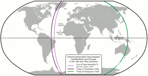
Signed on June 7, 1494, in Tordesillas, Spain, the treaty created a line of demarcation—an imaginary north-to-south line—located 370 leagues (approximately 2,100 km or 1,300 mi) west of the Cape Verde islands. Lands to the east of this line were granted to Portugal, while lands to the west belonged to Castile.
Key Facts
- Signed: June 7, 1494, in Tordesillas, Spain.
- Primary Goal: To divide newly discovered lands outside Europe between Portugal and Spain.
- The Boundary: A meridian 370 leagues west of the Cape Verde islands.
- Major Outcome: Portugal secured claims to the eastern coast of South America (modern-day Brazil) and routes to India.
- Successor Treaties: The Treaty of Zaragoza (1529) divided the eastern hemisphere, and the Treaty of Madrid (1750) eventually superseded Tordesillas.
From Papal Bulls to Diplomatic Agreement
The Treaty of Tordesillas did not emerge in a vacuum. It was a modification of earlier decrees by Pope Alexander VI. In 1493, the Pope issued the bull Inter caetera, which placed the line of demarcation only 100 leagues west of the Azores or Cape Verde. This initial line heavily favored Castile, granting them nearly all lands discovered by Christopher Columbus.
Portugal, dissatisfied with these terms and seeking to protect its African trade routes, negotiated for the line to be moved further west. The resulting Treaty of Tordesillas shifted the boundary, which inadvertently gave Portugal a claim to the "bulge" of South America. While Pedro Álvares Cabral officially landed in Brazil in 1500, some historians suggest the Portuguese were already aware of the land's existence before the treaty was signed.
The Challenge of Measurement
Defining the exact location of the Tordesillas meridian proved difficult because 16th-century cartography lacked precision. Different experts provided conflicting opinions on where the line actually fell:
- Jaime Ferrer (1495): Placed the line at 42°25′ W based on a sphere larger than the actual Earth.
- Cantino Planisphere (1501/1502): A Portuguese standard map that placed the line around 42°30′ W.
- Martin Fernández de Enciso (1518): Suggested a line that could be as far west as the mouth of the Amazon River.
- Badajoz Conference (1524): Spanish and Portuguese pilots nearly agreed on a position around 46° to 47° W, though no formal settlement was reached.
These discrepancies led to ongoing disputes over territory, particularly as explorers pushed further into the Pacific.
The Antimeridian and the Treaty of Zaragoza
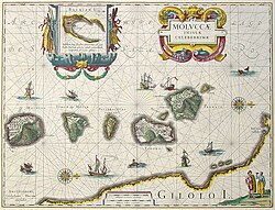
While the Tordesillas line divided the Atlantic, it did not initially encircle the globe. As explorers reached the other side of the world, a new conflict arose over the Moluccas (the "Spice Islands"). These islands were the only known source of cloves, a commodity so valuable it was worth its weight in gold.
Spain argued that the world should be divided into two equal hemispheres. After Ferdinand Magellan's fleet reached the Moluccas in 1521, Spain claimed the islands fell within their western half. To resolve this, the Treaty of Zaragoza was signed on April 22, 1529. Portugal paid Spain 350,000 gold ducats to relinquish its claims to the Moluccas.
This treaty established an antimeridian (the opposite side of the Tordesillas line), placing the boundary 17° east of the Moluccas. This effectively gave Portugal control over most of Asia, while Spain retained the Pacific Ocean and eventually colonized the Philippines, despite the islands technically falling within the Portuguese sphere.
Global Impact and Legacy
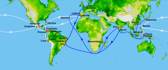
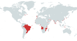
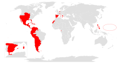
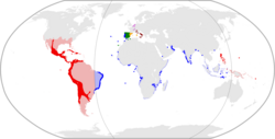
The division of the world was largely respected by the two Iberian powers, even during the Iberian Union (1581–1640) when both crowns were united under a single king. However, the Indigenous peoples of the Americas and Asia did not acknowledge these European claims.
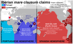
Over time, other European powers ignored the mare clausum (closed sea) claims of Spain and Portugal, leading to increased competition. The Tordesillas system remained in effect until the Treaty of Madrid in 1750. This final agreement voided the 1494 treaty, acknowledging Spanish sovereignty over the Philippines and granting Portugal the Amazon River basin.
| Treaty | Year | Primary Purpose | Key Outcome |
|---|---|---|---|
| Tordesillas | 1494 | Divide Atlantic/Americas | Portugal gets East (Brazil); Spain gets West. |
| Zaragoza | 1529 | Divide Pacific/Asia | Portugal secures Moluccas; Spain keeps Pacific. |
| Madrid | 1750 | Finalize South American borders | Tordesillas voided; Amazon basin given to Portugal. |
Frequently Asked Questions
Why was the Treaty of Tordesillas necessary?
It was necessary to prevent war between Spain and Portugal, who were both competing to claim newly discovered lands in the Americas and routes to Asia following Christopher Columbus's first voyage.
Did the treaty divide the world exactly in half?
No. While Spain later argued for equal hemispheres, the combined Tordesillas and Zaragoza lines divided the earth unequally, with Portugal's portion being roughly 191° and Spain's roughly 169°.
How did Brazil become Portuguese?
The Treaty of Tordesillas moved the demarcation line further west than the original Papal bull. This shift placed the easternmost part of South America within the Portuguese sphere, allowing Pedro Álvares Cabral to claim it in 1500.
What were the Moluccas and why were they important?
The Moluccas, or Spice Islands, were a small chain of islands in present-day Indonesia. They were the only place on Earth where cloves grew, making them incredibly lucrative for European trade.
What happened to the treaty in the end?
The Treaty of Tordesillas was eventually superseded and declared void by the Treaty of Madrid in 1750, which established more practical borders based on actual occupation of the land.