Togoland Protectorate: The Rise and Fall of Germany's West African Colony
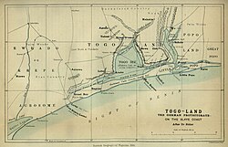
From 1884 to 1914, the Togoland Protectorate (known in German as Schutzgebiet Togo) served as a strategic outpost for the German Empire in West Africa. Spanning approximately 90,400 km², this territory encompassed the modern-day nation of Togo and a significant portion of the Volta Region in present-day Ghana. Established during the era of New Imperialism—specifically the competitive "Scramble for Africa"—Togoland evolved from a coastal foothold into a highly developed colonial possession.
The colony's trajectory was marked by rapid infrastructural growth and economic experimentation, eventually becoming one of Germany's few self-supporting overseas territories. However, its existence as a German protectorate ended abruptly with the onset of the First World War.
Key Facts
- Duration: 1884–1914.
- Capitals: Bagida (1884–87), Sebe (1887–97), and Lomé (1897–1916).
- Key Figures: Gustav Nachtigal (founder) and Hans Georg von Doering (final governor).
- Economy: Focused on scientific cultivation of cacao, coffee, and cotton.
- Outcome: Partitioned between France and Britain in 1916.
- Modern Legacy: Now divided between the Republic of Togo and Ghana.
The Establishment of German Rule
The foundation of Togoland was laid in 1884 through a series of treaties and strategic maneuvers. In February 1884, German soldiers abducted the chiefs of Aného, forcing them to sign a treaty of protection. Shortly after, on July 5, 1884, the German explorer and imperial consul Gustav Nachtigal signed a treaty with Chief Mlapa III. This act officially declared a German protectorate along the Slave Coast on the Bight of Benin, marked by the raising of the imperial flag with the gunboat SMS Möwe anchored nearby.
As Germany expanded its influence inland, it engaged in diplomatic trades with other powers. In 1899, Germany and Great Britain exchanged territories in the Samoan Islands for control in the Northern Solomon Islands and Tonga, using the Volta Triangle and the Togoland Neutral Zone (Yendi) as bargaining chips.
Economic Growth and Infrastructure
Togoland was often viewed as a "model colony" due to its advanced infrastructure. Colonial administrators introduced scientific cultivation methods for primary export crops, including cacao, coffee, and cotton. By 1914, the colonial office had constructed over 1,000 km of roads.
The transport network was anchored by three major rail lines originating in the capital, Lomé: a coastal line to Aného (1905), a line to Palime (1907), and the Hinterlandbahn (Lomé–Blitta railway), which reached Atakpamé and Blitta by 1911. This development transformed Lomé into a thriving hub, described at the time as the "prettiest town in West Africa."
Colonial Authority and the Polizeitruppe
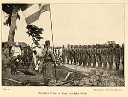
Maintaining control over the interior required military force. In 1888, the Polizeitruppe (police force) was organized with 25 Hausa infantry. By 1894, this force grew to 144 members and was used to suppress resistance in central Togo. These operations often involved razing towns and imposing heavy fines on inhabitants to enforce German authority.
World War I and the End of German Togoland
The outbreak of World War I in 1914 signaled the end of German rule. On August 7, 1914, British and French forces invaded the protectorate. Because no significant military personnel were stationed there—only a police force led by German sergeants—the colony was quickly overrun.
The strategic focus of the Allied forces was a powerful radio station near Kamina. To prevent the technology from falling into enemy hands, German technicians destroyed the station on the night of August 24/25. Governor Hans Georg von Doering officially surrendered the colony on August 26, 1914.
Partition and Transition
Following the surrender, the territory was split into British and French administrative zones on December 27, 1916. This division was formalized in 1922 under the League of Nations as Class B mandates: British Togoland and French Togoland.
| Period | Administrative Power | Status/Outcome |
|---|---|---|
| 1884–1914 | German Empire | Protectorate (Schutzgebiet Togo) |
| 1914–1922 | Britain & France | Military Occupation/Administrative Zones |
| 1922–1960 | Britain & France | League of Nations Mandates |
| Post-1960 | Ghana & Togo | Independent Nations |
The British-administered region eventually joined Ghana in 1957 following a 1956 plebiscite where 58% of residents voted for integration. The French-administered region became the Republic of Togo in 1960.
Frequently Asked Questions
Who founded the Togoland Protectorate?
The protectorate was primarily established through the efforts of Gustav Nachtigal, a German explorer and imperial consul, who signed a treaty with Chief Mlapa III on July 5, 1884.
What were the main exports of German Togoland?
The colony focused on the scientific cultivation and export of cacao, coffee, and cotton.
Why was the radio station at Kamina important?
The Kamina radio station was a vital communication link that sent reports and warnings to other German colonies (such as Kamerun and German East Africa) and ships at sea before it was destroyed by German technicians in 1914.
How was the territory divided after World War I?
Togoland was partitioned into French Togoland (approximately two-thirds of the territory) and British Togoland (approximately one-third), later becoming League of Nations mandates.
What happened to the proposed symbols of the colony?
In 1914, drafts for a coat of arms and flags were created, but because World War I broke out before they could be finalized, they were never officially implemented or used.