Tabula Peutingeriana: The Ancient Road Map of the Roman Empire
The Tabula Peutingeriana (Latin for 'The Peutinger Map') is a remarkable survivor of ancient cartography. Rather than a geographic map in the modern sense, it is an illustrated itinerarium—a road map designed to show the layout of the cursus publicus, the state-run courier and transportation network of the Roman Empire.
Unlike modern maps that prioritize precise landmass shapes, the Tabula is a schematic representation. It functions much like a modern transit map, distorting geography to provide a practical overview of routes, distances, and destinations for travelers across the ancient world.
Key Facts
- Physical Form: A parchment scroll measuring 6.75 meters long and 0.35 meters high.
- Scope: Covers Europe, North Africa, the Middle East, Persia, and the Indian subcontinent.
- Content: Features at least 555 cities and 3,500 place names.
- Current Location: Conserved at the Austrian National Library in Vienna.
- UNESCO Status: Added to the Memory of the World International Register in 2007.
The Archetype and Origins
The exact origins of the Tabula are a subject of scholarly debate. Many historians believe it is a distant descendant of a map created under Marcus Vipsanius Agrippa, a general and confidant to Emperor Augustus. This original archetype was reportedly engraved in stone and displayed in Rome's Porticus Vipsania.
Evidence for this early dating includes the inclusion of Pompeii, which was destroyed in AD 79 and never rebuilt. However, the map also shows Constantinople (founded in 328) and the prominence of Ravenna (the Western Empire's seat from 402 to 476), suggesting the original was revised in the 4th or early 5th century. A competing theory proposed by Emily Albu suggests the map might instead be based on a Carolingian-period original.
Map Design and Features
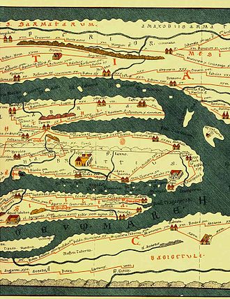
The Tabula is composed of eleven parchment sections. It utilizes a series of stepped lines to represent roads, with destinations marked in the order a traveler would encounter them. This format reflects the nature of ancient itineraries—lists of stops and distances rather than spatial coordinates.
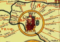
The map employs a sophisticated system of functional symbols to denote different types of settlements. While most towns are represented by simple icons, the three most critical cities of the empire—Rome, Constantinople, and Antioch—are highlighted with elaborate, individualized decorations.
The map's reach extends far beyond the borders of the Roman Empire. It includes references to India, the Ganges, Sri Lanka (Insula Taprobane), and even China. Notably, it marks a "Temple to Augustus" at Muziris on the Malabar Coast of India, a key trading port for Rome.
Missing Sections
The surviving copy is incomplete. The absence of the British Isles and the Iberian Peninsula (modern Spain and Portugal) indicates that a twelfth section of the original scroll was lost. This missing portion was later reconstructed in 1898 by scholar Konrad Miller.
History of Discovery and Preservation
The map is named after Konrad Peutinger, a 16th-century German antiquarian. It was first discovered in 1494 by the scholar Conrad Celtes in a library in Worms. Celtes bequeathed the map to Peutinger in 1508, though some scholars, including theologian Johann Eck, suggest the map may have been stolen by Celtes.
After passing through several royal families, the map was purchased by Prince Eugene of Savoy and eventually acquired by the Habsburg Imperial Court Library in 1737. Due to its extreme fragility, the original parchment is rarely displayed to the public.
| Feature | Details |
|---|---|
| Dimensions | 6.75m x 0.35m |
| Primary Purpose | Navigation of the Cursus Publicus |
| Key Cities | Rome, Constantinople, Antioch |
| Geographic Range | Europe, North Africa, Asia |
| Current Repository | Austrian National Library, Vienna |
Frequently Asked Questions
Is the Tabula Peutingeriana a geographically accurate map?
No. It is a schematic map, similar to a modern subway map. It distorts landmasses—particularly in the east-west direction—to prioritize the connectivity and distances of the road network over geographic precision.
Who was the map named after?
It is named after Konrad Peutinger, a German humanist and antiquarian who owned the map in the early 16th century and whose family held it for over two hundred years.
What is the 'cursus publicus'?
The cursus publicus was the state-run courier and transportation system of the Roman Empire, consisting of a vast network of roads and relay stations used for official government communication.
Why are the British Isles and Spain missing from the original?
The surviving parchment is a copy of an original scroll that consisted of twelve sections. The westernmost section, which contained the British Isles and the Iberian Peninsula, was lost over time.
When was the map first published for the public?
While sketches were published in 1591, the first full printed edition was published in December 1598 by Johannes Moretus in Antwerp, based on copies made for cartographer Abraham Ortelius.