Stony Brook
Stony Brook, known in the Lenape language as Wopowog, is a significant waterway flowing through Hunterdon and Mercer counties in New Jersey. As a primary tributary of the Millstone River, it plays a vital role in the regional hydrology of the United States' Garden State, eventually contributing its waters to the Raritan River and the Atlantic Ocean.
Key Facts
- Native Name: Wopowog (Lenape).
- Location: Hunterdon and Mercer counties, New Jersey.
- Destination: Drains into Lake Carnegie on the Millstone River.
- Elevation at Mouth: 49 feet (15 meters).
- Major Tributaries: Includes Honey Branch, Baldwins Creek, and Lewis Brook.
The Course of Stony Brook
The brook originates just south of Ringoes at coordinates 40°24′22″N 74°51′26″W. From its source, it flows south through the Amwell Lake Wildlife Management Area before shifting southeast. During this stretch, it runs parallel to Route 31, where it is joined by Peters Brook and Woodsville Brook.
As it continues its journey, the brook receives a tributary from Sourland Mountain and crosses Pennington-Hopewell Road. It passes through the Hopewell Valley Country Club and the nature reserve managed by the Stony Brook–Millstone Watershed Association, subsequently receiving the Stony Brook Branch.
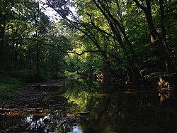
The waterway then flows between the Baldwin State Wildlife Management Area and Bristol-Myers Squibb, where it meets Baldwins Creek. After passing through Kunkel Park and receiving Lewis Brook, the brook turns east. It traverses Rosedale Park and Old Mill Road County Park, receiving Honey Branch along the way.
In its final stages, the brook navigates a mountainous region characterized by large meanders (winding curves in a river's course) before turning south near Coventry Farm Park. It passes through the Princeton Open Space Acquisition area and crosses Route 206, running parallel to Quaker Road (CR-533).
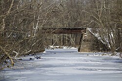
Upon reaching the Delaware and Raritan Canal, the brook turns northeast. After receiving Duck Pond Run from beneath the canal and crossing Alexander Street, it finally drains into Lake Carnegie on the Millstone River in southeastern Princeton (40°20′3″N 74°39′9″W).
Hydrological Network
Stony Brook is supported by a variety of tributaries that feed into its main stem. These smaller streams ensure the consistent flow of the brook as it moves toward the Millstone River.
| Tributary Side | Stream Names |
|---|---|
| Left Bank | Honey Branch |
| Right Bank | Baldwins Creek, Duck Pond Run, Lewis Brook, Peters Brook, Stony Brook Branch, Woodsville Brook |
Beyond its own direct tributaries, Stony Brook exists within a broader network of sister tributaries that also feed the Millstone River system. These include Beden Brook, Bear Brook, Cranbury Brook, Devils Brook, Shallow Brook, Harrys Brook, Heathcote Brook, Indian Run Brook, Little Bear Brook, Millstone Brook, Peace Brook, Rocky Brook, Royce Brook, Simonson Brook, Six Mile Run, Ten Mile Run, and Van Horn Brook.
Frequently Asked Questions
What is the Lenape name for Stony Brook?
The Lenape name for Stony Brook is Wopowog.
Where does Stony Brook eventually drain?
Stony Brook drains into Lake Carnegie on the Millstone River, located in the southeastern portion of Princeton, New Jersey.
Which counties does Stony Brook flow through?
The brook flows through Hunterdon and Mercer counties in the state of New Jersey.
What is the elevation of Stony Brook at its mouth?
The elevation at the mouth of the brook is 49 feet (15 meters).
What are some of the parks and reserves the brook passes through?
The brook flows through the Amwell Lake Wildlife Management Area, the Stony Brook–Millstone Watershed Association's nature reserve, Kunkel Park, Old Mill Road County Park, Rosedale Park, and Coventry Farm Park.