Stirlingshire: A History of Scotland's Strategic Heartland
Stirlingshire is a historic county in Scotland, serving as a vital gateway between the Highlands and the Lowlands. Centered around its county town of Stirling, the region has long been a focal point of military strategy, royal power, and administrative evolution. From the royal strongholds of the 12th century to its modern role as a registration county, Stirlingshire embodies the turbulent and triumphant spirit of Scottish history.
Key Facts
- County Town: Stirling
- Total Area: 447 sq mi (1,158 km²)
- Population (2022): 238,071
- Highest Point: Ben Lomond (974 metres / 3,196 ft)
- Key Water Bodies: Loch Lomond, Loch Katrine, and the River Forth
- Historic Significance: Site of the decisive Battle of Bannockburn (1314)
A Legacy of Conflict and Conquest
The history of Stirlingshire is inextricably linked to the struggle for Scottish independence. In 1130, King David I established Stirling as a royal burgh (a town with special trading privileges granted by the Crown), cementing its status as a principal royal stronghold.
The region's strategic location made it a frequent battlefield. On September 11, 1297, Andrew Moray and William Wallace secured a victory over English forces at the Battle of Stirling Bridge. However, this was followed by Wallace's defeat at the Battle of Falkirk in 1298. The tide turned again on June 24, 1314, when Robert the Bruce led Scottish forces to a decisive victory at the Battle of Bannockburn, a pivotal moment in the First War of Scottish Independence.
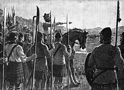
Later centuries continued this trend of military engagement. The Battle of Sauchieburn in 1488 saw a conflict between King James III and rebellious nobles led by his son, Prince James. In 1645, the Battle of Kilsyth became a major engagement of the Wars of the Three Kingdoms. Finally, in 1746, the Jacobites under Charles Edward Stuart defeated government forces at the Battle of Falkirk Muir.
Administrative Evolution
The origins of Stirlingshire as a shire (an area administered by a sheriff) date back to the reign of David I. Over centuries, its boundaries shifted, absorbing territories from West Lothian and Dunbartonshire.
Modern administration began in 1890 with the establishment of elected county councils. Initially, the burgh of Stirling managed its own affairs independently, though the county council remained based there. The council first met at the County Buildings on Barnton Street.
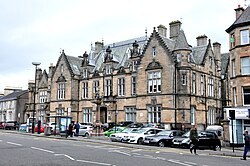
By 1930, the burgh of Stirling was integrated into the county council's administrative area. The council eventually moved its headquarters to Viewforth on Pitt Terrace in 1931, where it remained until the county's abolition for local government purposes in 1975.
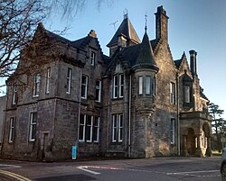
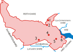
Under the Local Government (Scotland) Act 1973, Stirlingshire was replaced by a system of regions and districts. Most of the area joined the Central region, while parts near Kilsyth joined the Strathclyde region. Following further reforms in 1996, the historic county area now spans four council areas: Stirling, Falkirk, North Lanarkshire, and East Dunbartonshire.
Geography and Natural Landscape
Stirlingshire's landscape is diverse, ranging from industrial hubs to rugged wilderness. The western portion is dominated by the Trossachs and Loch Lomond, which the county shares with Dunbartonshire. This area includes Ben Lomond, the ninth highest peak in Scotland.
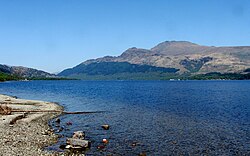
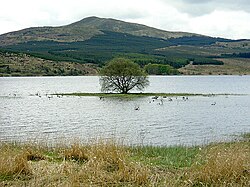
The central region features the Carron Valley Reservoir and several hill ranges, including the Campsie, Kilsyth, and Gargunnock Fells. The south-western corner, bordering the Greater Glasgow conurbation, is characterized by numerous small lochs and reservoirs, such as Mugdock Loch.
Infrastructure and Subdivisions
Transport in Stirlingshire is concentrated in the eastern third, where the population is densest. The M80 motorway connects Stirling and Denny to Cumbernauld, while the M9 provides a vital link to Edinburgh. Rail services in the east connect the region to Glasgow, Perth, and Edinburgh.
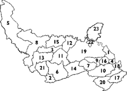
Historically, the county was divided into several burghs and civil parishes. The Royal Burgh of Stirling was the most prominent, alongside other burghs such as Falkirk, Grangemouth, and Kilsyth. For local government purposes until 1930, the county was divided into 23 civil parishes, including Airth, Balfron, and Slamannan.
![Map B: Stirlingshire Civil Parish map.[21]](/images/81/c7/81c79fa44a3310980664cf1764e925ba880d47e1a56b7735b18d84aca8fb1b21.jpg)
| Category | Details |
|---|---|
| Status | Historic County / Registration County |
| Key Towns | Stirling, Falkirk, Grangemouth, Kilsyth |
| Major Battles | Stirling Bridge, Falkirk, Bannockburn, Sauchieburn, Kilsyth |
| Highest Point | Ben Lomond (974m) |
| Administrative End | 1975 (Local Government purposes) |
Frequently Asked Questions
What is the significance of the Battle of Bannockburn?
The Battle of Bannockburn, fought on June 24, 1314, was a decisive Scottish victory in the First War of Scottish Independence, significantly strengthening Scotland's claim to sovereignty.
Is Stirlingshire still used for local government?
No, Stirlingshire was abolished for local government purposes in 1975. However, its pre-1975 boundaries are still used as a registration county for land registration.
What is the highest point in Stirlingshire?
The highest point is Ben Lomond, reaching an elevation of 974 metres (3,196 ft), making it the ninth highest peak in Scotland.
Which major towns are located in historic Stirlingshire?
Key towns include the county town of Stirling, as well as Falkirk, Grangemouth, Denny, and Kilsyth.
How did the administrative structure change in 1996?
The 1996 reforms abolished the regions and districts created in 1975, replacing them with single-tier council areas. The area of the historic county now falls under the jurisdiction of Stirling, Falkirk, North Lanarkshire, and East Dunbartonshire councils.