Stadland: A Coastal Municipality in Lower Saxony
Nestled on the left bank of the Weser river, Stadland is a serene municipality located in the Wesermarsch district of Lower Saxony, Germany. Positioned approximately 32 km northeast of Oldenburg and 42 km northwest of Bremen, this region is defined by its proximity to the water, bordering the Jade Bight to the west.
The municipality is characterized by a blend of organized village life and traditional Bauernschaften (small rural hamlets), creating a landscape that reflects the agricultural and maritime heritage of Northern Germany.
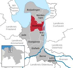
Key Facts
- Location: Wesermarsch district, Lower Saxony, Germany.
- Administrative Seat: Rodenkirchen.
- Total Area: 114.14 km².
- Population: 7,561 (as of December 31, 2024).
- Geography: Situated on the Weser river and the Jade Bight.
- Elevation: 1 meter above sea level.
Administrative Structure and History
Stadland was established in 1974 as a result of the Niedersächsische Gemeindereform (Lower Saxony municipal reform). This administrative restructuring merged several smaller entities to create the current municipality.
The formation of Stadland involved the integration of the former municipalities of Rodenkirchen, Schwei, and Seefeld. Additionally, the village of Kleinensiel, which was previously part of the municipality of Esenshamm (now known as Nordenham), was incorporated into the new administrative body.
Constituent Villages
The municipality is composed of several key villages that serve as local hubs, including:
- Rodenkirchen: The administrative seat of the municipality.
- Schwei
- Seefeld
- Kleinensiel
Regional Overview
Stadland operates within the Central European Time zone (UTC+01:00), shifting to Central European Summer Time (UTC+02:00) during the warmer months. Its low elevation of just 1 meter above sea level highlights its coastal nature.
| Category | Details |
|---|---|
| State | Lower Saxony |
| District | Wesermarsch |
| Mayor (2021–26) | Harald Stindt |
| Population Density | 66.24/km² |
| Postal Codes | 26935, 26936, 26937 |
| Vehicle Registration | BRA |
Frequently Asked Questions
Where is Stadland located?
Stadland is located in the Wesermarsch district of Lower Saxony, Germany, on the left bank of the Weser river and bordering the Jade Bight to the west.
Which villages make up the municipality of Stadland?
The municipality consists of the villages of Rodenkirchen, Schwei, Seefeld, and Kleinensiel, along with various small hamlets known as Bauernschaften.
When was the municipality of Stadland formed?
Stadland was created in 1974 during the Niedersächsische Gemeindereform, which merged Rodenkirchen, Schwei, Seefeld, and Kleinensiel.
What is the population of Stadland?
As of December 31, 2024, the total population of Stadland is 7,561.
Who is the current mayor of Stadland?
The mayor for the 2021–2026 term is Harald Stindt.