Sea of Japan: A Deep Dive into Geography, History, and Marine Life
The Sea of Japan is a complex and vital body of water situated between the Japanese archipelago and the Eurasian continent. Characterized by its unique "carrot-like" shape—wide in the south and narrowing toward the north—this sea serves as a critical maritime corridor. Its isolation, caused by relatively shallow straits, has created a distinct environment that influences everything from local climates to the diverse array of aquatic species that call it home.
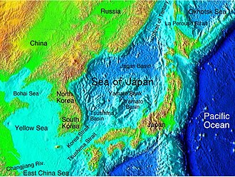
Key Facts
- Surface Area: Approximately 1,050,000 km² (410,000 sq mi).
- Maximum Depth: 4,568 meters (14,987 ft).
- Major Basins: Yamato Basin, Japan Basin, and Tsushima (Ulleung) Basin.
- Biodiversity: Home to over 3,500 animal species and 800 plant species.
- Naming: Known variously as the Sea of Japan, the East Sea (Korea), and the East Sea of Korea.
Geological Evolution and Physical Features
The geological history of the Sea of Japan is marked by significant tectonic activity. During the Late Miocene, the northern part of the Japanese archipelago underwent fragmentation and orogenesis—the process of mountain formation. While the southern part remained a large landmass, the north-eastern region saw the rise of high mountain ranges that continued through the Pliocene.
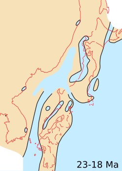
The sea's connectivity to the wider ocean is governed by several shallow straits, including the Tsugaru, Tsushima, and La Perouse straits. These narrow passages, often measuring 100 meters or less in depth, act as bottlenecks for water exchange. Geologically, these straits played a role in prehistoric animal migrations; for instance, the formation of the La Perouse Strait roughly 60,000 to 11,000 years ago closed the path used by mammoths moving toward northern Hokkaidō.
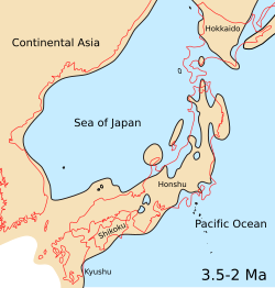
Basins and Seabed Composition
The sea is divided into three primary basins. The Japan Basin in the north is of oceanic origin and represents the deepest section. In contrast, the Tsushima Basin in the southwest is the shallowest. The seabed varies significantly: near the coast, it consists of continental material like mud, sand, and gravel, while deeper regions are dominated by pelagic sediments, such as red mud.
| Feature | Measurement |
|---|---|
| Surface Area | ~1,050,000 km² |
| Mean Depth | 1,752 m |
| Maximum Depth | 4,568 m |
| Total Coastal Length | ~7,600 km |
| Maximum Width | ~1,070 km |
Climate and Hydrology
The climate of the Sea of Japan is heavily influenced by monsoons. During winter, strong north-western winds bring cold, dry continental air, leading to high evaporation and heavy snowfall on Japan's western coasts. In summer, the winds reverse, bringing warm, humid air from the North Pacific. This seasonal shift also affects water temperatures, which can range from 0°C in the north during winter to 27°C in the south during summer.
![Von Kármán vortices off the coast of Rishiri Island[29]](/images/75/6c/756cb52d5cf4c7908af01153ee5a625a0b0878c4f3794c683d87b45822467fe7.jpg)
A unique meteorological phenomenon occasionally observed here is the von Kármán vortex. These turbulent cloud patterns form when strong winds blow over isolated, tall islands, such as Rishiri or Ulleungdo, creating swirling patterns in the low cloud layer.
Hydrologically, the sea is somewhat isolated, resulting in a lower average salinity (34.09‰) compared to the Pacific Ocean. The water is also highly oxygenated, particularly in the colder northern and western regions, which supports a robust biological community.
Historical Exploration and Maritime Activity
For centuries, the sea acted as a natural barrier, protecting Japan from land-based invasions, such as those by the Mongols. Since the 18th century, it has been a hub for international navigation. Notable explorers include the Frenchman Jean-François de Galaup, comte de Lapérouse, and the Russian navigator Adam Johann von Krusenstern.
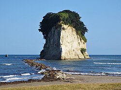
In the 19th century, the sea saw significant activity from American, Canadian, and French whaling ships. These vessels primarily targeted right whales, though they eventually shifted to humpback whales as right whale populations declined. During the peak years of 1848 and 1849, over 170 vessels were active in these waters.
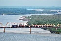
Rich Marine Biodiversity
The combination of high dissolved oxygen and varying depths supports a massive variety of life. The sea hosts more than 1,000 species of fish and 26 species of mammals. Pelagic fish, which live in the open ocean, include mackerel, sardines, and salmon. Meanwhile, demersal fish—those found near the sea floor—include cod and pollock.
![The mouth of Partizanskaya River near Nakhodka. View from Sopka Sestra [ru].](/images/ce/47/ce4718a4ac0d1fefbabb57b5c47115aac9a9fd3b79618b47107b3cd7f22e2301.jpg)
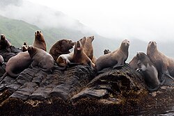
The coastal ecosystems are equally productive, with several kilograms of biomass per square meter. From the sea lions of Moneron Island to the diverse crustaceans found in the deeper basins, the Sea of Japan is a cornerstone of regional marine ecology.
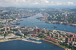
Frequently Asked Questions
Why is there a naming dispute regarding this sea?
The naming is a point of contention between nations. While many international organizations use "Sea of Japan," South Korea and North Korea refer to it as the "East Sea" or "East Sea of Korea," reflecting different historical and political perspectives.
What are von Kármán vortices?
These are peculiar, swirling cloud patterns that form when a stable field of wind flows past a tall, isolated obstacle, such as a mountainous island, creating a series of alternating vortices.
How do the straits affect the sea's water?
The relatively shallow straits (like the Tsushima and Tsugaru) limit the exchange of water with the Pacific Ocean. This isolation affects the sea's salinity, temperature layers, and the specific types of aquatic life that can thrive there.
What kind of fish are commonly found in the Sea of Japan?
The sea is rich in various species, including mackerel, sardines, anchovies, herring, squid, salmon, cod, and pollock.
How does the monsoon affect the sea's weather?
The winter monsoon brings cold, dry air and strong winds that cause high evaporation and heavy snow on western coasts. The summer monsoon brings warm, humid air from the North Pacific.