Resistencia: Argentina's Vibrant City of Sculptures
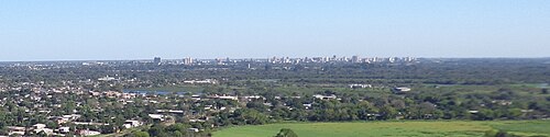
Located in the northeastern reaches of Argentina, Resistencia serves as the capital and largest city of the Chaco province. Known for its artistic spirit and strategic location along the Negro River, it acts as the anchor for the Greater Resistencia metropolitan area. With a population of 291,720 in the city proper (2010 census) and a total metropolitan population of 387,340, it stands as the eleventh most populous conurbation in the country.
Resistencia is more than just an administrative center; it is a cultural hub situated opposite the city of Corrientes. Its unique identity is shaped by a history of resilience, a diverse immigrant heritage, and a commitment to public art that has earned it a distinct reputation across Argentina.
Key Facts
- Nickname: The City of Sculptures.
- Founded: January 27, 1878.
- Geography: Situated on the Negro River, a tributary of the Paraná River.
- Climate: Humid subtropical (Cfa), characterized by hot, humid summers.
- Artistic Legacy: Home to over 500 public monuments and sculptures.
- Connectivity: Linked to Corrientes via the General Belgrano Bridge.
History and Foundation
Indigenous Roots and Early Settlement
Long before the city's formal establishment, the region was inhabited by Guaycuru aboriginal groups, including the Tobas. These pedestrian tribes relied on hunting and fishing. Among them were the Abipón, divided into the Riicagé (countryside), nacaigetergé (forest), and Yaaucanigá (river) groups, as well as the Payaguá, who were known for trade and piracy along the Paraná-Paraguay River. Their strong resistance to evangelization delayed significant European settlement until the late 19th century.
The Birth of a Capital
Resistencia was officially established as the territorial capital on January 27, 1878, following measurements executed by Arturo Seelstrang. The national government encouraged immigration to settle the region, leading to the arrival of the first Italian immigrants in 1878. This influence was so profound that the city's first City Council consisted entirely of Italian members. The arrival of Friulian immigrants is specifically commemorated every February 2.
Modern Development
The city's status evolved in 1953 when the National Territory of Chaco became a province, making Resistencia the provincial capital. The mid-20th century saw a surge in infrastructure, including the construction of the Resistencia International Airport and the development of essential public services, schools, and health centers during the governorships of Felipe Gallardo and Deolindo Felipe Bittel.
Geography and Climate
Resistencia is positioned at an elevation of 20 meters (66 ft) along the Negro River. Its climate is classified as humid subtropical (Cfa), making it one of the warmest cities in Argentina.
Summers are notoriously hot and humid, with daily highs typically between 30°C and 35°C (86°F to 95°F) and frequent afternoon thunderstorms. The record high was set on October 16, 2014, at 44.4°C (111.9°F). Conversely, the dry season runs from May to September. Winters can be unpredictable, alternating between tropical northerly patterns and cold southerly winds from the Pampas, with record lows reaching −4.7°C (23.5°F).
| Metric | Summer (Jan/Dec) | Winter (Jun/Jul) | Annual Average/Total |
|---|---|---|---|
| Mean Daily Max | 32.2°C to 33.4°C | 21.6°C to 21.7°C | 27.7°C |
| Mean Daily Min | 20.1°C to 21.2°C | 9.4°C to 11.1°C | 15.7°C |
| Avg Precipitation | ~168 mm | ~42 mm | 1,393.1 mm |
| Sunshine Hours | ~230 hrs/month | ~140 hrs/month | 2,201.6 hrs/year |
Culture and Economy
The Open-Air Museum
Resistencia is celebrated as an "open-air museum" due to the more than 500 sculptures and monuments decorating its streets. This artistic abundance is fueled by the Biennial International Sculptures Contest, established in 1988 and sponsored by UNESCO since 1997. The winning works are permanently installed in public parks and sidewalks.
The city also hosts several specialized museums, including the René Bruseau Provincial Museum of Fine Arts and the Juan Alfredo Martinet Museum of Anthropology.
Economic Evolution
While the city's economic foundations were originally built on trade and agriculture, recent decades have seen a significant shift toward the service sector, diversifying the local economy.
Transport and Infrastructure
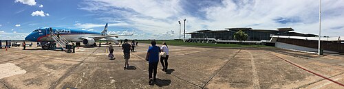
The Resistencia International Airport, operational since 1965, features a terminal designed by the modernist architect Amancio Williams. The city also serves as a critical air traffic control hub for northeastern Argentina.
Ground transportation is facilitated by National Routes 11 and 16. A vital link to the neighboring city of Corrientes is the General Belgrano Bridge, opened in 1973. While rail links were lost during the privatization of the 1990s, the provincially funded Sefecha line restored rail connectivity in 1997.
Frequently Asked Questions
Why is Resistencia called the "City of Sculptures"?
It earned this nickname because it has over 500 monuments and artworks displayed in public spaces, many of which were acquired through the UNESCO-sponsored Biennial International Sculptures Contest.
What is the climate like in Resistencia?
The city has a humid subtropical climate. It is known for extremely hot, humid summers with frequent lightning and a cooler, drier winter season.
Who were the original inhabitants of the Resistencia area?
The area was originally inhabited by Guaycuru aboriginal peoples, including the Tobas, Abipón, and Payaguá tribes.
How is Resistencia connected to the city of Corrientes?
The two cities are located opposite each other across the river and are connected by the General Belgrano Bridge, which has been in use since 1973.
What is the significance of February 2 in the city?
February 2 is celebrated as the arrival date of the first Friulian immigrants, though historical records indicate it coincides with the date the colony was created.