Pittsburgh Roads and Infrastructure: A City of Bridges and Expressways
Navigating Pittsburgh requires an understanding of its unique geography and complex transit network. From its historic wooden-paved streets to a massive network of bridges, the city's infrastructure is shaped by its rugged terrain and industrial heritage. However, maintaining these roads is a constant challenge, as the region's frequent freeze/thaw cycles—the process where water repeatedly freezes and melts in pavement cracks—often lead to significant road degradation during winter months.
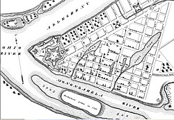
Notable Streets of Pittsburgh
Pittsburgh is home to several streets that are recognized for their historical significance or unique physical characteristics.
- Grant Street: Serving as the primary corridor for business and government, Grant Street is part of the Pittsburgh Central Downtown Historic District. It houses the regional Federal Government offices, the City of Pittsburgh, the seat of Allegheny County, and the global headquarters for Koppers Chemicals, Federated Investors, Oxford Development, and U.S. Steel.
- Canton Avenue: This street holds the distinction of being the steepest officially recorded public street in the United States.
- East Carson Street: Known for its high concentration of 19th-century homes, this area is often compared to Georgetown. It is a vibrant mix of residential properties, bars, and restaurants.
- Roslyn Place: Located in the Shadyside neighborhood, this small cul-de-sac is a historic district featuring a rare wooden pavement in the Nicolson Pavement style, dating back to 1914.
The Expressway System
The city's highway network is dominated by the "Parkway" system, which connects the urban core to the surrounding suburbs and the Pennsylvania Turnpike (I-76).
The Parkway Network
I-376 is divided into two primary sections. The Parkway East connects downtown to I-76. It is well-known for the Squirrel Hill interchange, where complex traffic patterns and a tunnel frequently cause congestion and occasional accidents involving oversized trucks. The Parkway West extends from downtown to the main terminal of the Pittsburgh International Airport, eventually merging into the Southern Expressway and Airport Parkway.
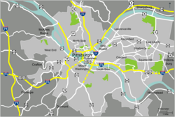
Running north of the city is I-279, known as the Parkway North. This route connects the city center with the Cranberry area and the North Hills before merging with I-79. Additionally, I-579, or the Crosstown Boulevard, acts as a spur off I-279 to reduce traffic in the North Shore and downtown areas, specifically serving the PPG Paints Arena and the convention center.
HOV Lanes and Safety
To manage rush-hour commuting, reversible High Occupancy Vehicle (HOV) lanes—which require at least two occupants per vehicle—are available on the Parkway North and a segment of I-579 over the Veterans Bridge. Notably, there is currently no "HOV OK" program for electric or hybrid vehicles. The danger of these reversible lanes was highlighted on August 25, 1995, when a PennDOT employee failed to follow safety procedures and left traffic gates open in both directions, resulting in a head-on collision that killed six people.
The Belt System and Wayfinding
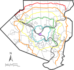
Unlike many major American cities, Pittsburgh does not have a contiguous beltway. While I-76, I-79, and I-70 form a rough triangle around the city, they are too distant from the center and require multiple exits and entries to navigate, making them impractical for suburb-to-suburb travel.
To mitigate this, the city utilizes the Allegheny County Belt System, which attempts to organize traffic without the need for new construction. Similarly, the Pittsburgh Wayfinder System helps travelers locate services and popular destinations within the city.
Bridges and Tunnels
Pittsburgh's landscape is defined by its water crossings, with over 2,000 bridges located throughout Allegheny County. Key crossings include the Fort Duquesne Bridge, the Liberty Bridge, and the iconic Three Sisters.
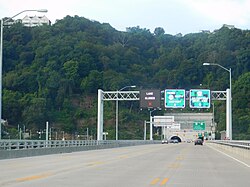
The Panhandle Bridge is a specialized former railroad bridge that now supports the Red, Silver, and Blue light rail lines of Pittsburgh Regional Transit across the Monongahela River. Access to downtown from the south is primarily managed via the Fort Pitt Bridge and the Fort Pitt Tunnel.
The city's tunnel network is equally extensive. Major vehicle tunnels include the Liberty, Armstrong, Squirrel Hill, and Fort Pitt tunnels. Public transit and specialized transport rely on the Mt. Washington Transit Tunnel, as well as the Corliss, Wabash, and Schenley tunnels.
Key Facts
- Bridge Capital: Allegheny County contains more than 2,000 bridges.
- Steepest Street: Canton Avenue is the steepest officially recorded public street in the U.S.
- Unique Paving: Roslyn Place is a historic wooden-paved street from 1914.
- Highway Layout: The city uses a "Parkway" system (North, East, and West) rather than a contiguous beltway.
- Transit Hub: The Panhandle Bridge supports three different light rail lines.
| Category | Key Examples | Notable Feature |
|---|---|---|
| Expressways | I-376 (Parkway East/West), I-279 (Parkway North) | Reversible HOV lanes on Parkway North |
| Bridges | Three Sisters, Liberty Bridge, Panhandle Bridge | Over 2,000 bridges in the county |
| Tunnels | Fort Pitt, Squirrel Hill, Liberty Tunnels | Critical for downtown access |
| Historic Streets | Roslyn Place, Canton Avenue | Wooden paving and extreme steepness |
Frequently Asked Questions
Why are Pittsburgh roads so difficult to maintain?
The difficulty is often attributed to the high number of freeze/thaw cycles during the winter, which damage the pavement.
Is there a beltway around Pittsburgh?
There is no dedicated contiguous beltway. While I-76, I-79, and I-70 form a triangular shape, the Allegheny County Belt System is used to manage suburb-to-suburb travel without new infrastructure.
What is the "Parkway" system?
The Parkway system consists of I-376 (Parkway East and West) and I-279 (Parkway North), which connect downtown Pittsburgh to the airport, the Pennsylvania Turnpike, and the North Hills.
Which street is the steepest in the United States?
Canton Avenue in Pittsburgh is the steepest officially recorded public street in the U.S.
What are the requirements for using HOV lanes in Pittsburgh?
HOV lanes on the Parkway North and parts of I-579 require a minimum of two occupants per vehicle; currently, there is no exception for electric or hybrid vehicles.