Mount Kilimanjaro: The Geology and Glacial History of Africa's Highest Peak
Mount Kilimanjaro stands as a testament to the powerful geological forces that shape our planet. Located 80 kilometres (50 mi) east of the tectonically active Rift Valley, this massive peak is situated at the intersection of tectonic plate lines. It is a central part of a 'Y'-shaped active continental rift system, where the earth's crust is pulling apart, allowing magma to rise to the surface.
The mountain's origins date back to the Miocene epoch, approximately 22–25 million years ago. During this period, rifting created deep fractures in the crust, providing the pathways for magma to ascend and eventually form the towering structure we see today.
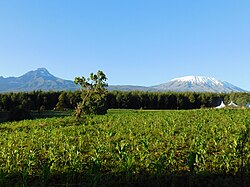
The Volcanic Structure
Kilimanjaro is classified as a stratovolcano—a conical volcano built up by many layers of hardened lava and tephra. The mountain is not a single peak but is composed of three overlapping volcanic cones: Shira, Mawenzi, and Kibo. While the rifting process began millions of years ago, the volcanic activity that created the mountain's current form is relatively recent, dating back less than a million years.
Residual Volcanic Activity
Although not currently erupting, the mountain exhibits signs of residual activity. This is most evident through fumaroles, which are openings in the earth's crust that emit steam and sulphur gases. These vents are primarily located within the summit's caldera—a large cauldron-like hollow that forms shortly after the emptying of a magma chamber.
Specifically, fumarolic activity is concentrated within nested summit craters, including the area around Reusch Crater, where vents continue to release gases at elevated temperatures.
The Retreat of the Glaciers
Historically, the summit of Mount Kilimanjaro was dominated by a massive ice cap, estimated to be more than 100 metres (330 ft) deep. These glaciers once extended far down the mountain, leaving behind moraine ridges—accumulations of dirt and rocks pushed forward by glacial ice—which remain visible on the southern flanks down to approximately 4,000 metres (13,000 ft).
In recent decades, this glacial cover has diminished significantly. The loss of ice is starkly evident when examining specific glaciers:
- Rebmann Glacier: Lost approximately 82 percent of its ice cover between 1912 and 2000.
- Furtwängler Glacier: Experienced a dramatic shrinkage, losing around 85 percent of its ice between October 1912 and June 2011. By 2018, its total area had reduced to just 11,000 m².
- Drygalski and Barranco Glaciers: These have either vanished entirely or now exist only as disconnected remnants.
Key Facts
- Formation: Began 22–25 million years ago during the Miocene.
- Composition: Three overlapping cones known as Shira, Mawenzi, and Kibo.
- Location: 80 km east of the Rift Valley on a tectonic plate intersection.
- Current Activity: Residual activity evidenced by steam and sulphur fumaroles.
- Glacial Loss: The Furtwängler Glacier shrank by 85% between 1912 and 2011.
The following table summarizes the status of the mountain's primary volcanic and glacial features:
| Feature | Type/Name | Key Detail |
|---|---|---|
| Volcanic Cones | Shira, Mawenzi, Kibo | Overlapping stratovolcanoes |
| Summit Feature | Caldera / Reusch Crater | Site of active gas vents |
| Glacial Remnant | Rebmann Glacier | 82% ice loss (1912–2000) |
| Glacial Remnant | Furtwängler Glacier | 11,000 m² area by 2018 |
Frequently Asked Questions
How was Mount Kilimanjaro formed?
It formed as magma rose through fractures created by a 'Y'-shaped active continental rift system. This process began during the Miocene, roughly 22–25 million years ago.
What are the three volcanic cones of Kilimanjaro?
The mountain is composed of three overlapping cones: Shira, Mawenzi, and Kibo.
Is Mount Kilimanjaro still volcanically active?
While not erupting, it shows residual activity in the form of steam and sulphur fumaroles, particularly around the Reusch Crater in the summit caldera.
What has happened to the glaciers on the mountain?
The glaciers have shrunk dramatically. For example, the Furtwängler Glacier lost about 85% of its ice between 1912 and 2011, and others, like the Drygalski and Barranco glaciers, have largely vanished.
What are moraine ridges?
Moraine ridges are deposits of rock and debris left behind by glaciers. On Kilimanjaro, these are visible on the southern flanks down to about 4,000 metres.