Metropolitan Region of Caracas
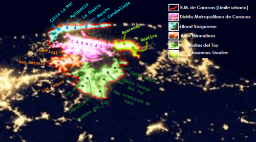
The Metropolitan Region of Caracas (MRC), also known as Greater Caracas (GC), is a vast urban agglomeration in Venezuela. Rather than being a single administrative unit, it is a complex conurbation—a region where several cities and towns have merged into one continuous urban area—spanning the Metropolitan District of Caracas and 11 adjacent municipalities across the states of Miranda and Vargas.
This expansive region spreads in all directions from the center of Caracas, stretching north, south, east, and west to integrate diverse landscapes and satellite cities into a single economic and social hub.
Key Facts
- Total Population: Approximately 5,297,026 residents.
- Total Area: 4,715.1 square kilometers (1,820.5 sq mi).
- Elevation Range: From a low of 25 meters (82 ft) to a peak of 2,200 meters (7,200 ft).
- Administrative Reach: Covers parts of the Caracas, Miranda, and Vargas states.
- Time Zone: UTC-4:30 (VST).
Metropolitan Divisions and Urban Structure
The Metropolitan Region of Caracas is organized into five distinct metropolitan divisions. These divisions help categorize the sprawling urban growth and the various satellite cities that support the capital.
Metropolitan District of Caracas
As the core of the region, this district is the most densely populated area, housing the city of Caracas itself. It serves as the primary administrative and commercial heart of the agglomeration.
Valles del Tuy Metropolitan Area
Located to the east, this area includes significant urban centers such as Ocumare del Tuy, Charallave, Santa Teresa del Tuy, and Cúa.
Guarenas-Guatire Metropolitan Area
This division is characterized by the twin cities of Guarenas and Guatire, which form a vital part of the eastern expansion of the region.
Altos Mirandinos Metropolitan Area
Situated in the highlands, this area includes Los Teques and San Antonio de Los Altos, offering a different topographical profile compared to the valley floor.
Litoral Varguense Conurbation
This coastal division connects the capital to the Caribbean, encompassing La Guaira, Maiquetia, Catia La Mar, and Caraballeda.
Regional Statistics Summary
The following table provides a detailed breakdown of the population, area, and primary cities within each metropolitan division based on census data.
| Metropolitan Division | Population (2011 Census) | Area (km) | Density (pop/km) | Major Cities |
|---|---|---|---|---|
| Metropolitan District of Caracas | 2,946,955 | 777.1 | 4,212.9 | Caracas |
| Valles del Tuy | 754,081 | 1,694 | 445.14 | Ocumare del Tuy, Charallave, Santa Teresa del Tuy, Cúa |
| Guarenas-Guatire | 473,728 | 558 | 848.97 | Guatire, Guarenas |
| Altos Mirandinos | 454,929 | 744 | 611.46 | Los Teques, San Antonio de Los Altos |
| Litoral Varguense | 341,325 | 942 | 362.34 | La Guaira, Maiquetia, Catia La Mar, Caraballeda |
| Total (MRC) | 4,832,026 | 4,715.1 | 1,223.41 | - |
Frequently Asked Questions
Is the Metropolitan Region of Caracas a single administrative city?
No, it is an urban agglomeration that comprises the Metropolitan District of Caracas and 11 municipalities across the states of Miranda and Vargas; it does not constitute a single administrative unit.
What are the highest and lowest points of the region?
The region's elevation ranges from a low of 25 meters (82 ft) to a high of 2,200 meters (7,200 ft).
Which division is the most densely populated?
The Metropolitan District of Caracas is the most densely populated, with approximately 4,212.9 people per square kilometer.
Which states are included in Greater Caracas?
The region spans across the Caracas, Miranda, and Vargas states of Venezuela.
What are the main cities in the Litoral Varguense area?
The primary cities in this coastal conurbation are La Guaira, Maiquetia, Catia La Mar, and Caraballeda.