Manasquan Reservoir Trails
Spanning a vast 1,204-acre area, the Manasquan Reservoir offers a serene escape for nature enthusiasts and outdoor adventurers. The park features a network of 6.2 miles of trails designed for an easy-to-moderate physical challenge, providing a blend of accessible paths and immersive nature walks that wind around the reservoir and through diverse ecosystems.
Whether you are looking for a long-distance stroll on a wide gravel path or a quiet trek through the woods, the park's trail system caters to various preferences and skill levels.
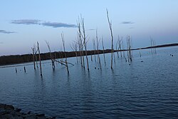
Key Facts
- Total Trail Mileage: 6.2 miles across five distinct trails.
- Primary Trail: The Perimeter Trail (5.1 miles) circles the reservoir.
- Terrain: Ranges from level crushed gravel to natural ground with mud puddles.
- Accessibility: Perimeter Trail width varies from 8 to 24 feet; side trails are typically 3 feet wide.
- Key Features: Includes wildlife observation blinds, footbridges, and an environmental center.
The Perimeter Trail: The Park's Main Loop
The Perimeter Trail is a 5.1-mile (8.2 km) multi-use loop that completely surrounds the reservoir. Designed for accessibility, the surface consists mostly of level crushed gravel (quarry stone). The trail is clearly marked with blue metal posts and brown wooden mileposts that run in a clockwise direction, starting from the southern portion of the park near the visitors' parking area.
Starting at the southern parking lot, the trail heads west along Windeler Road before turning north toward the environmental center (located near milepost 1.3). It then follows a northeasterly course parallel to Georgia Tavern Road, leading to Chestnut Point, a popular spot for recreational fishing. The path continues east along Peskin Road and Southard Avenue, crossing the Manasquan Water Supply System's main utility service road around mile 3.3. As it returns toward the visitors' parking lot, the trail narrows to 8 feet near milepost 4 before expanding again to 20 feet at its conclusion.
The following table outlines the key facilities and landmarks found along the Perimeter Trail:
| Milepost | Facility, Service, or Feature |
|---|---|
| 0.0 | Start (Milepost Marker) |
| 0.1 | Johnny-on-the-spot toilets |
| 0.6 | Cove Trail entrance |
| 1.3 | Environmental Center and parking lot / Park map |
| 1.7 | Chestnut Point parking lot / Toilets / Large Park map |
| 1.8 | Dike / Fishing pier |
| 2.4 | Wildlife observation blind |
| 3.5 | Dam road crossing |
| 4.5 | Service driveway / Park map / Bear Swamp Connector Trail |
| 5.1 | End (Visitor's western parking area) |
Specialized Nature and Connector Trails
Cove Trail
The 1.1-mile (1.8 km) Cove Trail is a dedicated nature path marked in green. It begins at mile 0.7 of the Perimeter Trail and ends at the picnic area by the environmental center. Unlike the main loop, this trail is very narrow, requiring hikers to walk in single-file. It follows the natural ground without a gravel base, meaning hikers may encounter mud puddles. This trail winds through the southern lakeshore woods and wetlands, featuring two bridges, two boardwalks, and a wildlife viewing area. Binoculars are highly recommended here for wildlife sightseeing.
Wetlands Spur (Lakeside Trail)
Located at the eastern end of the visitor center parking lot (used by watercraft trailers), the Wetlands Spur is a short 0.2-mile path. It provides direct access to the lake's shore for fishing and sightseeing. Along the way, visitors will find a picnic area, a wildlife observation blind, a small wooden pedestrian bridge, and a resting bench facing the water before the path connects back to the Perimeter Trail.
Bracken Trail
The Bracken Trail is a 0.2-mile loop located behind the Environmental Center. This narrow, quarry-stone path is reserved for pedestrians and explores the immediate lakeside area. A highlight of this trail is the inclusion of approximately a dozen labeled indigenous flora and fauna, listed with their scientific names for educational purposes.
Bear Swamp Connector Trail
The Bear Swamp Connector Trail is a 0.5-mile path located in the Bear Swamp Tract at the eastern end of the park. Approximately 8 feet wide, this trail serves as a link between the Perimeter Trail (at mile 4.5, across Old Tavern Road) and Howell Township's Oak Glen Park. It is intended for casual walking and requires hikers to return via the same path to reach the reservoir.
Frequently Asked Questions
Which trail is best for a long walk?
The Perimeter Trail is the best option for long walks, offering a 5.1-mile loop around the reservoir on a mostly level, crushed gravel surface.
Are the trails suitable for all skill levels?
Yes, the trails are generally rated as easy-to-moderate. The Perimeter Trail is the most accessible, while the Cove Trail is more challenging due to its natural terrain and potential for mud.
Where can I see wildlife in the park?
Wildlife observation is encouraged on the Cove Trail and the Wetlands Spur, both of which feature dedicated wildlife viewing areas or blinds.
Is there a trail that connects to other parks?
Yes, the Bear Swamp Connector Trail provides a 0.5-mile link between the Manasquan Reservoir's Perimeter Trail and Howell Township's Oak Glen Park.
What should I bring when hiking the Cove Trail?
Because the Cove Trail is a nature path with natural ground, it is advisable to wear footwear suitable for mud and to bring binoculars for wildlife viewing.