Kahramanmaraş: A Journey Through the Heroic City of Turkey
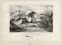
Located in the heart of Turkey's Mediterranean region, Kahramanmaraş is a city where ancient history and modern resilience intersect. Historically known as Marash or Germanicea, the city serves as the administrative center of the Kahramanmaraş province. Its name was officially updated in 1973 to include the prefix kahraman (meaning "heroic") to honor the city's role in the Battle of Marash.
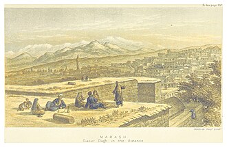
The city is situated on a fertile plain at the foot of Mount Ahır, acting as a gateway between the coastal Mediterranean influences and the rugged continental interior of Anatolia.
Key Facts
- Official Name: Kahramanmaraş (formerly Marash).
- Location: Mediterranean region, Turkey.
- Elevation: 568 meters (1,864 ft) above sea level.
- Population: 571,266 (Urban, 2022).
- Key Landmark: The Ceyhan River, the city's most significant hydrological feature.
- Famous Export: Traditional Turkish Ice Cream (Kahramanmaraş Ice cream).
A Deep Dive into History
Early Civilizations and the Iron Age
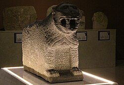
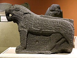
The roots of Kahramanmaraş stretch back to the early Iron Age (late 11th century BC to ca. 711 BC), when it served as the capital of the Syro-Hittite state known as Gurgum (or Kurkuma in Hieroglyphic Luwian). To the Assyrians, the city was known as Marqas. By 711 BC, the region was annexed as an Assyrian province.
The Roman and Byzantine Eras
During the Roman and Byzantine empires, the city was renamed Germanicia Caesarea. This period was marked by various phonetic spellings and toponymic confusions common to the era. Archaeological evidence of the earlier Kurkumaean settlements has been unearthed in the Dulkadiroğulları quarters of the modern city.
Medieval Transitions and the Ottoman Empire
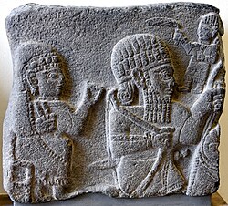
The medieval period saw the city change hands frequently between the Danishmends, the Seljuks, and the Crusaders. In 1114, a devastating earthquake reportedly killed 40,000 people. Later, from 1337 to 1515, the city was ruled by the Beylik of Dulkadir as vassals of the Mamluk Empire before eventually being annexed by the Ottoman Empire.
Modern Era and Independence
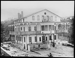
The 20th century brought significant turmoil, including conflicts during World War I and the Turkish War of Independence. The city experienced a period of French occupation before Turkish nationalist forces regained control in February 1920. In later years, the city was the site of the 1978 Maraş Massacre, an event that contributed to the declaration of martial law and the 1980 military coup.
Geography, Climate, and Culture
Environmental Profile
Kahramanmaraş features a Mediterranean climate (Köppen: Csa) with continental influences. This results in hot, dry summers—with record highs reaching 47.2 °C (117.0 °F)—and cool, wet winters. The Ceyhan River is the primary water source for the region.
Urban Life and Demographics
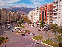
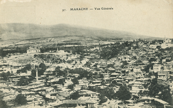
The city has grown steadily from a population of 7,500 in the early 16th century to over half a million today. While historically home to diverse ethnic groups including Turks and Armenians, the modern population is predominantly Turkish and Kurdish.
Local Attractions and Industry
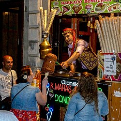
Beyond its history, the city is famous for its unique Turkish Ice Cream, a dense, stretchy delicacy that originates here. For those seeking outdoor activity, the Yedikuyular Ski Resort, located at an elevation of 2,300 meters, provides winter sports opportunities.
Recent Challenges: The 2023 Earthquakes
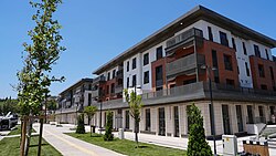
On February 6, 2023, a catastrophic 7.8 magnitude earthquake struck with epicenters in Pazarcık and Elbistan. The disaster caused widespread destruction, with an estimated 17.37% of the city destroyed and more than 50,000 deaths recorded in the broader region. The city center was among the hardest-hit areas.
City Overview Summary
| Feature | Detail |
|---|---|
| Coordinates | 37°35′N 36°56′E |
| Region | Mediterranean, Turkey |
| Elevation | 568 m |
| Urban Population (2022) | 571,266 |
| Time Zone | UTC+3 (TRT) |
| License Plate | 46 |
Frequently Asked Questions
Why is the city called "Kahramanmaraş"?
The prefix "Kahraman" means "heroic" in Turkish. It was added to the city's name in 1973 to commemorate the bravery shown during the Battle of Marash.
What is the significance of the Ceyhan River?
The Ceyhan River is the most important hydrological feature in the city, originating from the mountains surrounding the Elbistan Plain.
What is the weather like in Kahramanmaraş?
The city has a Mediterranean climate with continental influences. This means summers are very hot and dry, while winters are cool and wet.
What happened during the 2023 earthquakes?
A powerful 7.8 magnitude earthquake struck the region on February 6, 2023, destroying approximately 17.37% of the city and causing over 50,000 deaths.
What is the city's most famous food?
The city is the birthplace of traditional Turkish Ice Cream, known for its unique texture and preparation method.