Inverness-shire: The History and Geography of Scotland's Largest Historic County
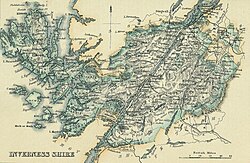
Inverness-shire stands as a titan of Scottish geography, once serving as the largest historic county in Scotland. Spanning a diverse landscape that stretches from the rugged mainland to the remote reaches of the Hebrides, it has played a pivotal role in the administrative and political evolution of the Highlands. While its role in local government changed significantly in the late 20th century, its legacy remains etched in the land and the law.
At its peak, the county covered a staggering 4,211 square miles, making it the largest of Scotland's 34 historic counties and second only to Yorkshire in the entire United Kingdom. Its borders were defined by the Moray Firth to the east and the Sea of the Hebrides to the west, encompassing some of the most iconic landscapes in the British Isles.
Key Facts
- Total Area: 4,211 sq mi (10,906 km), the largest historic county in Scotland.
- County Town: Inverness.
- Administrative Shift: Ceased to be used for local government purposes in 1975.
- Geography: Included mainland areas, the Inner Hebrides (notably Skye), and parts of the Outer Hebrides.
- Highest Point: Home to Ben Nevis, the tallest mountain in Britain.
The Evolution of the Shire
The administrative boundaries of Inverness-shire were not static. In the 15th century, following the incorporation of the Lordship of the Isles into the kingdom of Scotland, the Sheriff of Inverness was granted responsibility for the Outer Hebrides and parts of the Inner Hebrides, including Skye.
By 1504, the area was recognized as too vast for the effective administration of justice. This led to an act of parliament declaring Ross and Caithness as separate shires. Although this was briefly set aside in 1509, the northern territories eventually regained independence through the creation of the shires of Sutherland (1633), Caithness (1641), and Ross-shire (1661). Following these separations, Inverness-shire consisted of the western province of Moray on the mainland and the southern portions of the Hebrides.
From Commissioners to County Councils
Administrative power shifted over time from the old provinces to the shires. In 1667, Commissioners of Supply—the primary administrative bodies of the time—were established. Following the Acts of Union in 1707, the English term "county" began to be used interchangeably with the traditional Scottish "shire." In 1890, the Local Government (Scotland) Act 1889 replaced the commissioners with elected county councils.
Governance and the County Council
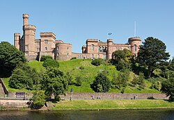
The Inverness-shire County Council first convened on May 22, 1890, at Inverness Castle, a landmark rebuilt in 1836. Interestingly, the burgh of Inverness was excluded from the council's administrative area because it was deemed capable of managing its own county-level functions, though the council continued to use the town as its base.
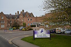
By the 1930s, the council moved its offices to the former Inverness College building on Glenurquhart Road, known as the County Buildings. This site was expanded in 1963, though formal meetings remained at the castle until the council's abolition in 1975.
The Rockall Claim
In a unique geopolitical footnote, the UK Government claimed sovereignty over Rockall, an uninhabited North Atlantic islet, in 1955. Under the Island of Rockall Act 1972, this remote rock was officially assigned to the Harris district of Inverness-shire, a claim that remains disputed by Ireland.
Geography and Natural Landmarks
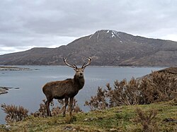
The geography of Inverness-shire is defined by its dramatic water bodies and mountainous terrain. The county is home to numerous lochs (Scottish lakes), including the world-famous Loch Ness and the expansive Loch Quoich.
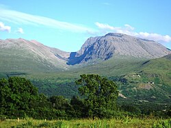
The mainland is dominated by the Highlands, featuring Ben Nevis, the highest peak in Britain.
The Islands
The county's reach extended far into the Atlantic, covering two distinct island groups:
- Inner Hebrides: Including the large Isle of Skye, as well as Raasay, Rùm, Eigg, Muck, Canna, and others.
- Outer Hebrides: Including Barra, Benbecula, North and South Uist, and part of the Lewis and Harris island.
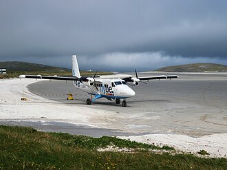
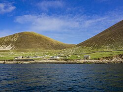
The islands are known for their unique infrastructure and history, such as Barra's beach airport runway and the evacuated village of Hirta on St Kilda.
Modern Administrative Status
The 1975 local government reforms ended the use of Inverness-shire for administrative purposes. The mainland and Inner Hebrides portions became part of the Highland region (later a council area in 1996), while the Outer Hebrides became part of the Western Isles (Na h-Eileanan an Iar).
Despite these changes, the historic boundaries of Inverness-shire are still utilized for specific official purposes, such as land registration. Additionally, the lieutenancy areas established in 1975 continue to be recognized.
County Summary
| Feature | Details |
|---|---|
| Total Area | 4,211 sq mi (10,906 km) |
| County Town | Inverness |
| Key Islands | Skye, Barra, North Uist, South Uist, Harris |
| Major Landmarks | Ben Nevis, Loch Ness, Inverness Castle |
| Current Status | Registration county; split between Highland and Western Isles council areas |
Frequently Asked Questions
What happened to Inverness-shire in 1975?
In 1975, the county ceased to be used for local government purposes. Its territories were divided between the Highland region (mainland and Inner Hebrides) and the Western Isles (Outer Hebrides).
Is Inverness-shire still used for anything today?
Yes, the boundaries of the historic county are still used as a registration county for certain official land registration purposes.
Which islands were part of Inverness-shire?
The county included several islands in the Inner Hebrides, most notably Skye, and several in the Outer Hebrides, including Barra, Benbecula, and the Uists.
What is the significance of Rockall to the county?
Under the Island of Rockall Act 1972, the uninhabited islet of Rockall was assigned to the Harris district of Inverness-shire, though this sovereignty is disputed by Ireland.
Where were the county council meetings held?
While the council's main offices were located in the County Buildings on Glenurquhart Road, formal meetings continued to be held at Inverness Castle until 1975.