Inverness IV Postcode Area: Coverage and Logistics
The IV postcode area, commonly referred to as the Inverness postcode area, serves a vast and diverse region of north Scotland. Spanning across the rugged landscapes of the Highlands and parts of Moray, this postal network ensures the efficient delivery of mail to some of the most remote locations in the United Kingdom.
Centrally managed and coordinated, the IV area is a critical component of the UK's postal infrastructure, balancing dense urban hubs like Inverness with expansive rural districts.
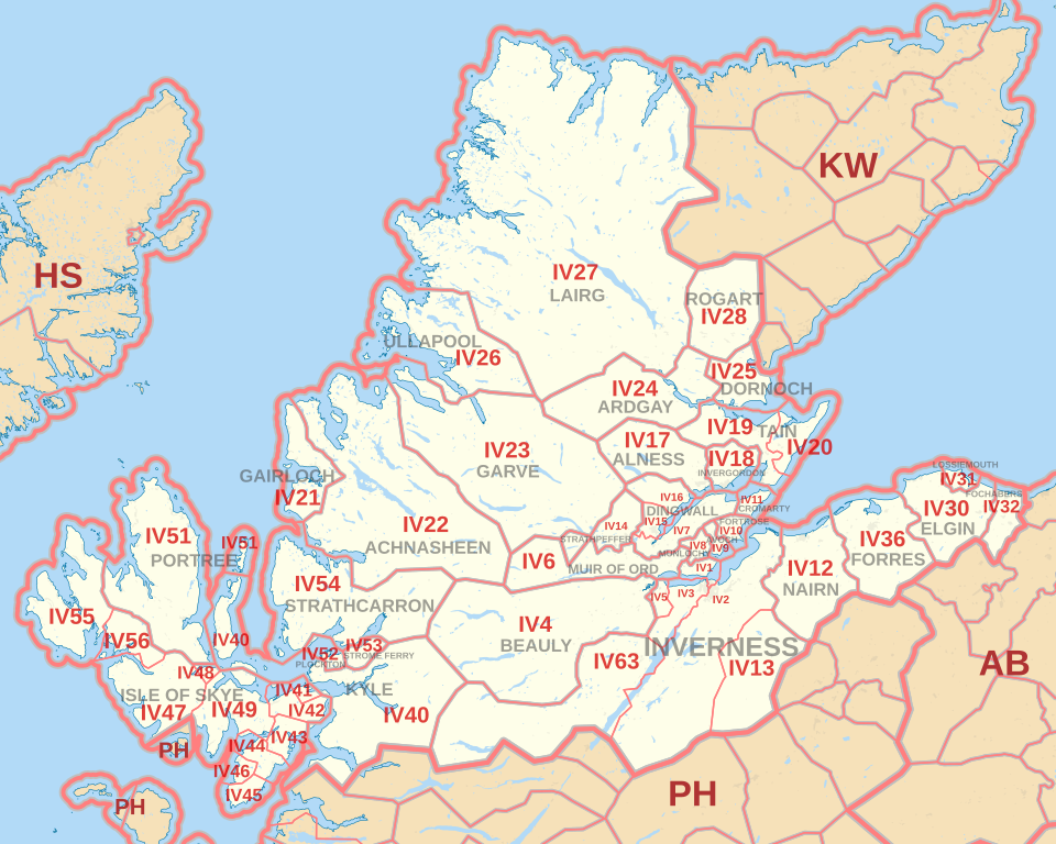
Key Facts
- Primary Hub: Mail is processed at the Inverness Mail Centre, which also handles the KW and HS postcode areas.
- Scale: The area comprises 31 post towns and 53 postcode districts.
- Largest District: IV27 (Lairg) is the largest postcode district in the UK by area, covering 1,393 square miles.
- Volume: As of May 2020, there are 7,356 live postcodes and a total of 10,739 postcodes.
- Administrative Reach: Coverage primarily spans the Highland and Moray local authority areas.
Postal Infrastructure and Administration
The logistics of the IV area are centralized at the Inverness Mail Centre. This facility acts as the primary sorting hub not only for the IV districts but also for the neighboring KW (Kirkwall) and HS (Hrosay/Outer Hebrides) postcode areas, highlighting Inverness's role as the logistical heart of the north.
The area is divided into 84 postcode sectors, which further break down into individual postcodes. While most districts are geographic, some, such as IV99, are non-geographic, meaning they are assigned to specific large-volume users, such as the Jobcentre Plus.
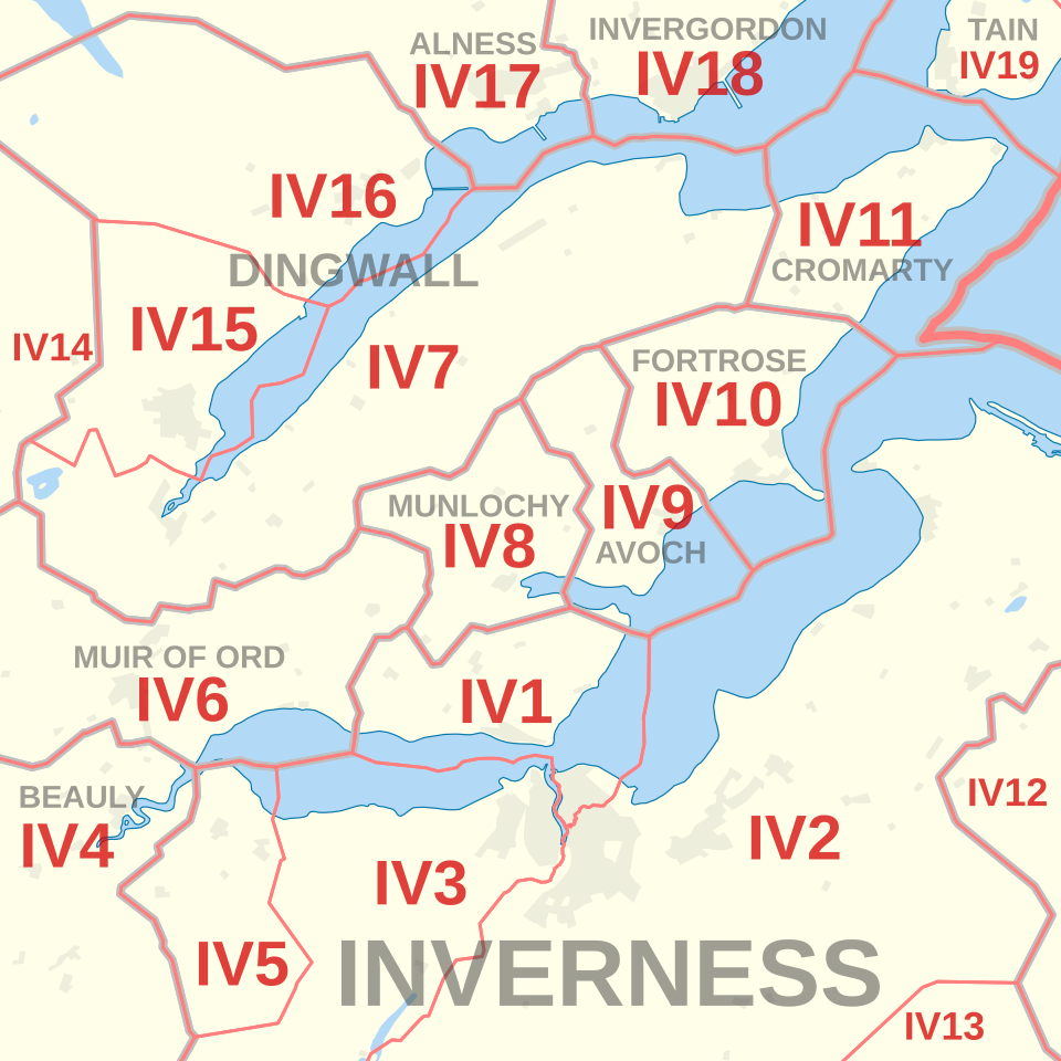
Detailed Coverage and Districts
The IV postcode area covers a wide array of post towns, ranging from the bustling center of Inverness to the coastal reaches of the Isle of Skye and the remote wilderness of Lairg. The distribution is split mainly between two local authority areas: Highland and Moray.
Highland Local Authority Coverage
The majority of the IV area falls under the Highland council. This includes the central Inverness districts (IV1, IV2, IV3, IV5, IV13, and IV63), as well as outlying towns such as Dingwall, Alness, Tain, and Ullapool. A significant portion of the area is dedicated to the Isle of Skye, spanning districts IV41 through IV49 and IV55 to IV56.
Moray Local Authority Coverage
The eastern edge of the IV postcode area extends into Moray, covering key towns including Elgin (IV30), Lossiemouth (IV31), Fochabers (IV32), and Forres (IV36).
Historical Changes
Postal boundaries occasionally shift to optimize delivery. For example, districts IV33, IV34, and IV35—which previously covered Carron, Knockando, and Rothes—were transferred to the Aberlour post town and recoded as AB38 in August 1994.
Summary of IV Postcode Statistics
| Metric | Value |
|---|---|
| Post Towns | 31 |
| Postcode Districts | 53 |
| Postcode Sectors | 84 |
| Live Postcodes | 7,356 |
| Total Postcodes | 10,739 |
| Largest District Area (IV27) | 1,393 sq miles |
Frequently Asked Questions
Which is the largest postcode district in the UK?
The IV27 district, centered around Lairg, is the largest postcode district in the United Kingdom by land area, covering 1,393 square miles.
Where is mail for the IV postcode area processed?
Mail for the IV area is processed at the Inverness Mail Centre, which also handles mail for the HS and KW postcode areas.
Which local authority areas does the IV postcode cover?
The IV postcode area primarily covers the Highland and Moray local authority areas in north Scotland.
What is a non-geographic postcode in the IV area?
A non-geographic postcode is one not linked to a specific physical area but to a specific organization. An example in the IV area is IV99, which is used by Jobcentre Plus.
Are there any recent changes to the IV postcode boundaries?
Yes, in August 1994, the districts IV33, IV34, and IV35 (covering Carron, Knockando, and Rothes) were recoded to AB38 after being transferred to the Aberlour post town.