Indian Subcontinent: Geography, Geology, and Regional Identity
The Indian subcontinent is a distinct physiographic region of Asia, characterized by a massive landmass that projects into the Indian Ocean. Bound by the towering Himalayas to the north, the Arabian Sea to the west, and the Bay of Bengal to the east, this region is a complex intersection of geological power and diverse geopolitical identities.
While often used interchangeably with the term South Asia, there is a subtle distinction between the two. The term "Indian subcontinent" is primarily geophysical, describing the physical landmass. In contrast, "South Asia" is a geopolitical designation. While South Asia typically includes Bhutan, the Maldives, Nepal, and Sri Lanka, it sometimes extends to include Afghanistan—a country not generally considered part of the physical subcontinent.
Key Facts
- Total Area: Approximately 4,440,000 square kilometers.
- Population: Roughly 1.9 billion people.
- Core Countries: India, Pakistan, and Bangladesh.
- Extended Region: Includes Bhutan, Maldives, Nepal, and Sri Lanka.
- Defining Border: The Himalayas serve as the primary northern boundary.
- Major Water Bodies: Flanked by the Arabian Sea and the Bay of Bengal.
Defining the Subcontinent
The term "subcontinent" refers to a large landmass that is smaller than a continent but possesses a distinct geographical, cultural, or political identity. Historically, the region southeast of the Indus River was simply called "India." In modern historical contexts, this name is often used to describe the entire region prior to the era of the British Raj.
The usage of these terms has evolved with political shifts. Following the Partition of India in 1947 and the independence of Bangladesh in 1971, the term "Indian subcontinent" has become less common in Pakistan and Bangladesh, where it can be perceived as emphasizing Indian dominance. Consequently, "South Asia" has emerged as a more neutral alternative in international and academic parlance.
Interestingly, the term persists in specific cultural contexts. In the world of international cricket, the region comprising India, Pakistan, Sri Lanka, Nepal, Bangladesh, and Afghanistan is frequently referred to as "the subcontinent," with players often discussing "subcontinental conditions" regarding the pitch and climate.
Geological Evolution
The formation of the subcontinent is a result of massive tectonic movements. Long before the Indian plate collided with Eurasia, other landmasses known as terranes (crustal blocks that have traveled far from their origin) were involved. The Qiangtang and Lhasa terranes were part of a string of microcontinents called Cimmeria.
Cimmeria rifted from Gondwana and drifted toward Eurasia, closing the Paleo-Tethys Ocean and opening the Neo-Tethys Ocean. This movement eventually led to the Cimmerian Orogeny, a period of mountain building caused by the collision with Eurasia.
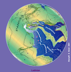
As the Lhasa terrane joined Eurasia, subduction—the process where one tectonic plate sinks beneath another—began along its southern flank. This activity created the Gangdese batholith in the Tibetan trans-Himalaya. Simultaneously, the Kohistan-Ladakh island arc formed through oceanic subduction, eventually drifting north to collide with Eurasia.
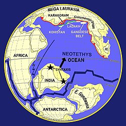
The final collision between the Indian plate and Eurasia closed the Neo-Tethys Ocean entirely. The point where the two continental crusts welded together is known as the Indus-Yarlung suture zone. This zone lies north of the Himalayas, and its geography continues to influence the region today, as the headwaters of the Indus and Brahmaputra rivers flow along this suture.
Regional Overview
The subcontinent is home to some of the world's most populous cities and diverse landscapes, from the Thar Desert to the fertile plains of the Ganges and Brahmaputra rivers.
| Category | Details |
|---|---|
| Countries | Bangladesh, Bhutan, India, Maldives, Nepal, Pakistan, Sri Lanka |
| Major Cities | Delhi, Mumbai, Dhaka, Karachi, Kolkata, Chennai, Lahore, Bangalore, Hyderabad, Ahmedabad |
| Official Languages | Bengali, Dzongkha, English, Hindi, Dhivehi, Nepali, Sinhala, Tamil, Urdu |
| Key Landforms | Himalayas, Tibetan Plateau, Deccan Plateau, Hindu Kush, Karakoram |
| Dependencies/Disputed | British Indian Ocean Territory, Kashmir |
Frequently Asked Questions
What is the difference between the Indian subcontinent and South Asia?
The Indian subcontinent is a geophysical term referring to the physical landmass south of the Himalayas. South Asia is a geopolitical term that describes the region's political and cultural entities, often including a broader set of countries.
Which countries are part of the Indian subcontinent?
The core physical region is divided between India, Pakistan, and Bangladesh. In a broader regional sense, it includes Bhutan, Nepal, Sri Lanka, and the Maldives.
How were the Himalayas formed?
The Himalayas were formed by the collision of the Indian plate with the Eurasian plate, which closed the Neo-Tethys Ocean and pushed the earth's crust upward.
What is the Indus-Yarlung suture zone?
It is the geological "seam" or suture zone that marks where the Indian plate welded to the Eurasian plate, located north of the Himalayan range.
Why is the term "Indian subcontinent" controversial in some countries?
In Pakistan and Bangladesh, the term is sometimes viewed as offensive because it places India in a dominant position, potentially overshadowing the independent identities of the other nations.