Heinrich Kiepert: A Legacy of Precision in Historical Cartography
The field of historical cartography—the study and practice of creating maps of the ancient world—was profoundly shaped by the meticulous work of Heinrich Kiepert. Through a career spanning several decades, Kiepert blended academic rigor with practical exploration, producing atlases and guides that became standard references for scholars and travelers alike.
Key Facts
- Academic Tenure: Taught geography at the University of Humboldt-Berlin from 1854 until his death.
- Major Works: Authored influential texts including Lehrbuch der alten Geographie and Formae orbis antiqui.
- Field Experience: Conducted four separate expeditions to Asia Minor between 1841 and 1848.
- Commercial Impact: Contributed specialized maps to the world-renowned Baedeker travel guides.
- Global Reach: His works were translated into multiple languages, including English and French.
Early Career and Foundations in Ancient Greece
Kiepert began his professional journey in 1840, collaborating with Carl Ritter to publish Atlas von Hellas und den hellenischen Kolonien. This initial work focused specifically on ancient Greece, establishing his expertise in reconstructing historical landscapes through geographical data.
By 1841, his skills were utilized for Biblical Researches in Palestine, a groundbreaking book by Edward Robinson. Kiepert's ability to translate textual research into accurate visual maps provided a new level of precision to Middle Eastern studies.
Expanding the Global and Historical Record
Throughout the mid-19th century, Kiepert expanded his scope from regional studies to comprehensive global and historical atlases. In 1848, he released the Historisch-geographischer Atlas der alten Welt, followed by the Atlas antiquus in 1854, which gained international acclaim and was translated into five languages.
His commitment to contemporary geography was evidenced in 1855 with the publication of Neuer Handatlas über alle Teile der Erde, a general atlas covering all parts of the globe.
Exploration of Asia Minor and the Ottoman Empire
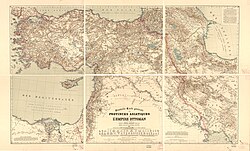
Kiepert was not merely a studio cartographer; he was an explorer. Between 1841 and 1848, he traveled to Asia Minor four times to gather first-hand data. This fieldwork culminated in the creation of two significant regional maps, most notably the Karte des osmanischen Reiches in Asien (Map of the Ottoman Empire in Asia) in 1844.
Academic Contributions and Travel Guides
In 1854, Kiepert joined the faculty of the University of Humboldt-Berlin, where he taught geography for the remainder of his life. His academic influence continued through the publication of Lehrbuch der alten Geographie (1877) and Leitfaden der alten Geographie (1879). The latter was translated into French and into English as A Manual of Ancient Geography in 1881.
Beyond academia, Kiepert applied his precision to the commercial sector by creating maps for Baedeker publishing. He produced essential guides for Egypt and Palestine, as well as European cities and regions, including:
- South Italy and Sicily: Italie du Sud et la Sicile (3rd ed., 1872).
- London: London nebst Ausflügen nach Süd-England, Wales u. Schottland (5th ed., 1875).
- Paris: Paris ses environs et les principaux itinéraires des pays limitrophes à Paris (3rd ed., 1874).
His final major contribution began in 1894 with the first part of Formae orbis antiqui, an ambitious and expansive atlas of the ancient world.
Summary of Major Works
| Year | Title | Focus/Scope |
|---|---|---|
| 1840 | Atlas von Hellas und den hellenischen Kolonien | Ancient Greece |
| 1844 | Karte des osmanischen Reiches in Asien | Ottoman Empire in Asia |
| 1854 | Atlas antiquus | Ancient World (Translated into 5 languages) |
| 1855 | Neuer Handatlas über alle Teile der Erde | Global Geography |
| 1879 | Leitfaden der alten Geographie | Ancient Geography Manual |
| 1894 | Formae orbis antiqui | Comprehensive Ancient World Atlas |
Frequently Asked Questions
Where did Heinrich Kiepert teach?
Heinrich Kiepert taught geography at the University of Humboldt-Berlin from 1854 until his death.
Which regions did Kiepert visit for his research?
Kiepert traveled to Asia Minor four times between 1841 and 1848 to inform his cartographic work.
Did Kiepert contribute to any commercial travel guides?
Yes, he created maps for Baedeker publishing, specifically for their guides on Egypt, Palestine, Paris, London, and South Italy.
What was the significance of the Atlas antiquus?
Published in 1854, the Atlas antiquus was a major work of historical geography that achieved wide international reach, being translated into five different languages.
What was Kiepert's final major project?
In 1894, he began the first part of Formae orbis antiqui, a large-scale atlas dedicated to the ancient world.