Gunma Prefecture: A Comprehensive Overview
Gunma is one of only eight inland prefectures in Japan, situated as the northwesternmost region of the Kantō plain. While the central and southeast areas serve as the primary population hubs, the majority of the prefecture is defined by its rugged, mountainous terrain. Gunma shares borders with Niigata and Fukushima to the north, Tochigi to the east, Nagano to the west, and Saitama to the south.
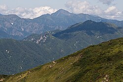
The landscape is dominated by several prominent peaks, including Mount Akagi, Mount Haruna, Mount Myōgi, Mount Nikkō-Shirane, and Mount Asama, the latter of which sits on the border with Nagano Prefecture. The region's hydrology is shaped by major waterways such as the Tone River, the Agatsuma River, and the Karasu River.
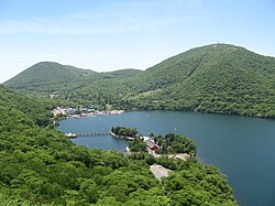
Environmental preservation is a priority in the region. As of April 1, 2012, approximately 14% of Gunma's total land area is designated as Natural Parks. These include the Jōshin'etsu-kōgen, Nikkō, and Oze National Parks, as well as the Myōgi-Arafune-Saku Kōgen Quasi-National Park.
Key Facts
- Location: Northwesternmost prefecture of the Kantō plain; one of eight inland prefectures in Japan.
- Topography: Predominantly mountainous, except for the southeast and central regions.
- Climate Extreme: Isesaki recorded 41.8 °C on August 5, 2025, the highest temperature ever registered in Japanese history.
- Conservation: 14% of land is protected within National or Quasi-National Parks.
- Capital: Maebashi.
Administrative Divisions
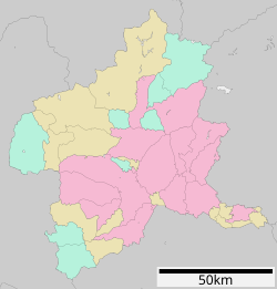
Gunma is organized into twelve cities and various towns and villages distributed across several districts.
Cities of Gunma
The prefecture's urban centers vary significantly in size and population, with Takasaki and Maebashi serving as the largest hubs.
| City (Rōmaji) | Kanji | Area (km²) | Population |
|---|---|---|---|
| Takasaki | 高崎市 | 459.16 | 372,369 |
| Maebashi (Capital) | 前橋市 | 311.59 | 335,352 |
| Ōta | 太田市 | 175.54 | 224,358 |
| Isesaki | 伊勢崎市 | 139.44 | 213,303 |
| Kiryū | 桐生市 | 274.45 | 108,991 |
| Shibukawa | 渋川市 | 240.27 | 76,098 |
| Tatebayashi | 館林市 | 60.97 | 74,027 |
| Fujioka | 藤岡市 | 180.29 | 64,539 |
| Annaka | 安中市 | 276.31 | 57,013 |
| Midori | みどり市 | 208.42 | 50,266 |
| Tomioka | 富岡市 | 122.85 | 47,911 |
| Numata | 沼田市 | 443.46 | 46,908 |
Towns and Villages
Beyond the cities, Gunma consists of numerous smaller municipalities organized by district. Notable areas include the large Minakami town in the Tone District, which covers 781.08 km², and the densely populated Ōizumi town in the Ōra District.
Climate and Weather Patterns
Due to its inland position, Gunma experiences significant temperature fluctuations between summer and winter and generally receives less precipitation than coastal regions. A defining characteristic of the local winter is the karakkaze (literally "empty wind").
The karakkaze is a strong, dry wind created when moisture-laden clouds moving from the coast are obstructed by the Echigo Mountains. While snow falls on the coast of Niigata, the high peaks prevent the moisture from passing through, transforming the air into the dry wind that sweeps across Gunma.
The region is also prone to extreme heat. On August 5, 2025, the city of Isesaki recorded a temperature of 41.8 °C, marking the hottest temperature ever recorded in Japan. For comparison, the capital city of Maebashi maintains an average yearly temperature of 14.2 °C with an average yearly precipitation of 1,163 mm.
Frequently Asked Questions
What is the karakkaze?
The karakkaze is a strong, dry winter wind unique to the region. It occurs when the Echigo Mountains block snow-bearing clouds from the Niigata coast, stripping the air of its moisture before it reaches Gunma.
Which city in Gunma has the highest population?
Based on the provided data, Takasaki is the most populous city with 372,369 residents.
What is the capital of Gunma Prefecture?
The capital of Gunma Prefecture is Maebashi.
How much of Gunma is protected as a Natural Park?
As of April 1, 2012, 14% of the prefecture's total land area is designated as Natural Parks, including several National Parks and one Quasi-National Park.
What is the record for the highest temperature in Japan?
The highest temperature ever registered in Japanese history was 41.8 °C, recorded in Isesaki, Gunma, on August 5, 2025.