Gulf Stream: The Powerful Ocean Current Shaping Global Climate
The Gulf Stream is one of the most influential forces in the Earth's climate system. A warm, swift Atlantic ocean current, it originates in the Gulf of Mexico, surges through the Straits of Florida, and tracks along the eastern coastline of the United States. As it reaches approximately 36°N latitude near North Carolina, it veers eastward, transforming into the North Atlantic Current and carrying warmth toward Northwest Europe.
This massive movement of water is part of the North Atlantic Gyre—a large system of circulating ocean currents. Through a process known as western intensification, the current accelerates as it moves northward along the North American coast. Eventually, around 40.000°N 30.000°W, the stream splits: the northern branch, known as the North Atlantic Drift, crosses toward Northern Europe, while the southern branch, the Canary Current, recirculates off the coast of West Africa.
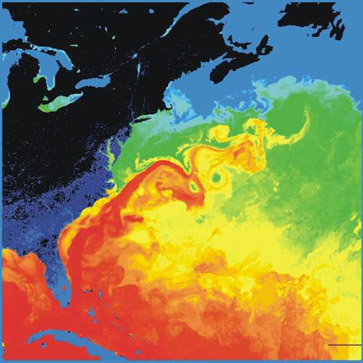
Key Facts
- Origin: Gulf of Mexico, flowing through the Straits of Florida.
- Volume: Transports 30 million cubic metres per second (30 sverdrups) through the Florida Straits, increasing to 150 sverdrups south of Newfoundland.
- Dimensions: Typically 100 km wide and 800 to 1,200 m deep.
- Maximum Speed: Approximately 2.5 m/s (5.6 mph) near the surface.
- Climate Impact: Keeps Northwest Europe significantly warmer than other regions at similar latitudes.
- Recent Findings: Studies published in 2018 suggest the current may be at its weakest point in 1,600 years.
The History of Discovery and Mapping
European awareness of the Gulf Stream began in 1512 during the expedition of Juan Ponce de León. His logs from April 1513 describe a current so powerful that ships were pushed backward despite having strong winds in their favor.
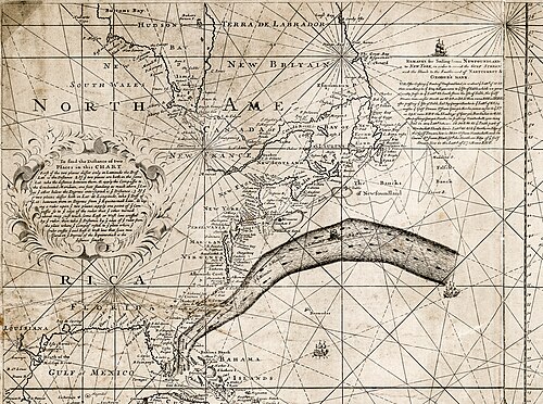
Centuries later, Benjamin Franklin sought to improve transatlantic travel. Consulting his cousin Timothy Folger, a Nantucket whaling captain, Franklin learned that sailors identified the current by observing whale behavior, water temperature, and water color. Franklin used this knowledge to create a chart of the Gulf Stream, which was first printed in London in 1769. While initially ignored by British captains, the chart was later published in Paris and Philadelphia.
Modern oceanography has since evolved far beyond early charts. In the 1950s and 60s, research vessels and moored meters provided the first direct measurements. By the late 1970s, satellite remote sensing—using sea-surface temperature (SST) imagery and altimetry—allowed for real-time mapping. NASA’s TOPEX/Poseidon mission (1992) and the global Argo float network now provide a three-dimensional view of the current's structure and its role in the Atlantic Meridional Overturning Circulation (the large-scale system of ocean currents that transports heat from the tropics to the poles).
Physical Properties and Behavior
The Gulf Stream is primarily a western-intensified current driven by wind stress. In contrast, the North Atlantic Current is driven largely by thermohaline circulation—a process where water moves based on differences in temperature (thermo) and salinity (haline).
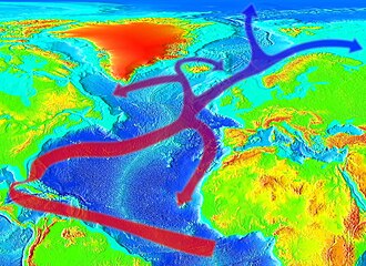
As the warm water travels north, it undergoes wind-driven evaporative cooling. This process increases the water's salinity and density. Additionally, when sea ice forms, salts are excluded from the ice (brine exclusion), further increasing the density of the surrounding liquid water. This cold, dense water eventually sinks, creating a downdraft that becomes part of the North Atlantic Deep Water, a south-going stream.
The sheer volume of the Gulf Stream is staggering. At 150 sverdrups south of Newfoundland, it dwarfs all rivers emptying into the Atlantic combined, which total only 0.6 sverdrups. However, this strength can lead to sea-level anomalies that increase coastal erosion along the U.S. East Coast.
Impact on Weather and Cyclone Formation
The Gulf Stream acts as a massive heat engine for the atmosphere. In Florida, the Florida Current maintains winter water temperatures of at least 24°C (75°F), which helps keep the state milder than other Southeastern U.S. regions during winter.
The temperature contrast at the edge of the current is a catalyst for storm development. Tropical cyclones typically require water temperatures above 26.5°C (79.7°F), a condition common over the Gulf Stream in July. These storms often track northward along the current, gaining intensity. A prominent example occurred in 2012, when Hurricane Sandy intensified as it followed the axis of the Gulf Stream.
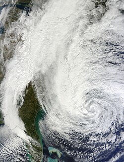
Beyond tropical storms, the current influences extratropical and subtropical cyclones. Between 1951 and 2000, approximately 75% of documented subtropical cyclones formed near the Gulf Stream, peaking in May and October. Some oceanic cyclones even form beneath the current, reaching depths of 3,500 m.
Gulf Stream Summary Table
| Feature | Details / Value | Primary Driver/Effect |
|---|---|---|
| Flow Rate (Florida Straits) | 30 Sverdrups | Wind Stress |
| Flow Rate (S. Newfoundland) | 150 Sverdrups | Western Intensification |
| Max Surface Speed | 2.5 m/s (5.6 mph) | Current Velocity |
| Typical Width | 100 km | Physical Dimension |
| Typical Depth | 800 to 1,200 m | Physical Dimension |
| European Climate | Warmer/Milder | North Atlantic Current |
Frequently Asked Questions
Why is Northwest Europe warmer than other places at the same latitude?
Northwest Europe is warmer largely because of the North Atlantic Current, which transports warm water from the Gulf Stream across the Atlantic, releasing heat into the atmosphere of the region.
What is a "Sverdrup" in the context of the Gulf Stream?
A Sverdrup is a unit used to measure the volume of water transported by an ocean current. One Sverdrup equals one million cubic metres of water per second.
How does the Gulf Stream affect hurricanes?
The warm waters of the Gulf Stream provide the thermal energy necessary for tropical cyclone generation (requiring temperatures above 26.5°C). Storms tracking along the current's axis, such as Hurricane Sandy, can gain significant strength.
What is brine exclusion?
Brine exclusion occurs when sea ice forms; the salt is left out of the ice crystals and enters the surrounding water. This increases the water's salinity and density, causing it to sink and contribute to the North Atlantic Deep Water stream.
Is the Gulf Stream currently weakening?
Yes, two studies published in the journal Nature in April 2018 indicated that the Gulf Stream is at its weakest state in at least 1,600 years.