Gondwana: The Assembly and Fragmentation of a Giant Supercontinent
Millions of years before the modern map of the world existed, the Earth's landmasses were arranged in vast, singular blocks. One of the most significant of these was Gondwana, a massive supercontinent that dominated the southern hemisphere. Covering approximately 100,000,000 km²—roughly one-fifth of the Earth's surface—Gondwana served as the foundation for many of today's continents, including Africa, South America, Australia, Antarctica, and India.
The story of Gondwana is one of violent collisions and slow drifts, spanning hundreds of millions of years from its initial accretion to its eventual breakup.
Key Facts
- Formation: Began approximately 800 to 650 million years ago (Ma).
- Maximum Size: Covered about 20% of the Earth's surface during the Paleozoic Era.
- Composition: Formed from the accretion of several cratons (large, stable blocks of the Earth's crust).
- Pangaea Connection: Fused with Laurasia during the Carboniferous period to create the larger supercontinent Pangaea.
- Breakup Trigger: Linked to the eruption of the Karoo-Ferrar igneous province between 200 and 170 Ma.
The Assembly of a Supercontinent
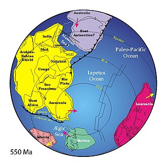
Gondwana did not form all at once but through a series of orogenies (mountain-building events caused by tectonic plate collisions). The process began between 800 and 650 Ma with the East African Orogeny, where India and Madagascar collided with East Africa.
By 600 to 530 Ma, the assembly reached its peak. The Brasiliano and Kuunga orogenies saw South America collide with Africa, while Australia and Antarctica were added to the mass. By 550 Ma, India had reached its position, triggering the Kuunga (or Pinjarra) orogeny. Simultaneously, the closure of the Adamastor Ocean brought the Kalahari region into contact with Congo and Rio de la Plata.
The final stages of assembly were completed around 540–530 Ma when the closure of the Mozambique Ocean brought India adjacent to Australia and East Antarctica.
The Terra Australis Orogen
Along the western, southern, and eastern margins of the supercontinent, an 18,000 km-long chain known as the Terra Australis Orogen developed. Evidence of these Cambrian arc belts can still be found today in Tasmania, New Zealand, eastern Australia, and Antarctica.
Gondwana and the Path to Pangaea
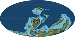
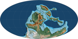
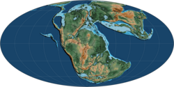
As the Paleozoic Era progressed, Gondwana became the largest piece of continental crust on the planet. During the Carboniferous period, it eventually fused with another large landmass, Laurasia, to form the all-encompassing supercontinent Pangaea.
The Great Fragmentation
The breakup of Gondwana was a complex process that propagated clockwise around Antarctica, which sat at the center of the supercontinent. This fragmentation was driven largely by the eruption of the Karoo-Ferrar igneous province—one of Earth's most extensive large igneous provinces—between 200 and 170 Ma.
The initial separation occurred during the Jurassic period (c. 180 to 160 Ma) in the southern Weddell Sea, where the oldest magnetic anomalies between South America, Africa, and Antarctica are located.
The Opening of the Indian Ocean
East Gondwana (Antarctica, Madagascar, India, and Australia) eventually separated from Africa. Between 132.5 and 96 Ma, India began moving northwest away from Australia and Antarctica. This movement was accompanied by volcanic activity from the Kerguelen hotspot, which created the Kerguelen Plateau (118–95 Ma) and the Ninety East Ridge (c. 100 Ma).
The Isolation of Antarctica and Australia
Australia and East Antarctica began their separation around 132 Ma, with seafloor spreading occurring by 96 Ma. A significant climatic shift occurred during the Eocene (c. 35.5 Ma) when oceanic crust finally separated the two continents, causing global ocean temperatures to drop significantly. Additionally, Zealandia (including New Zealand) separated from West Antarctica around 84 Ma.
![Eastern Gondwana. 620 to 550 Ma post-collisional extension of the East African Orogeny in blue and 570 to 530 Ma collisional metamorphism of the Kuunga orogeny in red.[11]](/images/8f/e3/8fe33672c6909b9ee4d5924e5212ef367aa5a1419c27c87d6eb8ede8fcdb21c0.png)
Summary of Gondwana's Evolution
| Period/Event | Approximate Time | Key Tectonic Activity |
|---|---|---|
| Initial Formation | 800–650 Ma | East African Orogeny; India/Madagascar collide with Africa. |
| Final Assembly | 600–530 Ma | Brasiliano and Kuunga orogenies; addition of South America, Australia, and Antarctica. |
| Pangaea Phase | Carboniferous | Fusion with Laurasia. |
| Initial Breakup | 200–160 Ma | Karoo-Ferrar eruptions; separation in the Weddell Sea. |
| Indian Ocean Opening | 132.5–96 Ma | India moves northwest; Kerguelen hotspot activity. |
| Final Separation | 35.5 Ma | Australia and Antarctica fully separate; global temperature drop. |
Frequently Asked Questions
What exactly was Gondwana?
Gondwana was a supercontinent that formed during the Neoproterozoic era and existed through the Paleozoic. It consisted of the landmasses that now make up South America, Africa, Antarctica, Australia, India, and Arabia.
How did Gondwana differ from Pangaea?
Gondwana was a smaller supercontinent that existed before Pangaea. Eventually, Gondwana fused with another landmass called Laurasia to form the even larger supercontinent known as Pangaea.
What caused Gondwana to break apart?
The breakup was primarily driven by plate tectonics and massive volcanic activity, specifically the eruption of the Karoo-Ferrar igneous province between 200 and 170 million years ago.
How did the breakup of Gondwana affect the Earth's climate?
The separation of Australia and Antarctica around 35.5 million years ago allowed for the creation of deep-ocean gateways, which led to a significant drop in global ocean temperatures.
What is an orogeny and why is it important to Gondwana?
An orogeny is a mountain-building event resulting from the collision of tectonic plates. Events like the East African and Kuunga orogenies were the primary mechanisms that fused separate cratons into the single landmass of Gondwana.