German States: History, Governance, and Regional Structure
Germany is organized as a federal republic consisting of 16 federated states, known in German as Länder (singular: Land). While the term Bundesland is commonly used to describe these entities, the official constitutional terminology remains Länder. These states are not merely administrative districts but political entities with their own governments, legislatures, and specific constitutional roles within the Federal Republic.
The current structure of Germany is the result of centuries of political evolution, moving from a fragmented collection of hundreds of small territories to a unified federal system. Today, these states vary significantly in size and population, ranging from the city-state of Bremen to the expansive territory of Bavaria.
Key Facts
- Number of States: 16 federated states.
- Largest State by Area: Bavaria (70,541 km²).
- Most Populous State: North Rhine-Westphalia (approx. 18 million people).
- Smallest State by Area: Bremen (419.4 km²).
- Governance: Each state has its own state government and legislature (usually called a Landtag).
- Special Status: Bavaria, Saxony, and Thuringia officially designate themselves as Freistaaten (Free States).
Historical Evolution of German Federalism
From the Holy Roman Empire to the German Empire
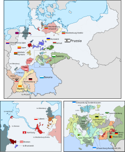
Federalism has deep roots in German history. Before the 19th century, the region was part of the Holy Roman Empire, which consisted of over 300 individual political entities by 1796. This fragmentation was reduced during the Napoleonic Wars, leading to the creation of the 39-state German Confederation in 1815.
Following the Austro-Prussian War of 1866, Prussia emerged as the dominant power, leading to the formation of the North German Confederation. By 1871, after the Franco-Prussian War, the southern states joined to form the German Empire. In this era, the Kingdom of Prussia was the hegemon, accounting for 65% of the territory and 62% of the population.
The Weimar Republic and the Nazi Era
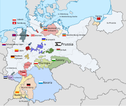
After World War I, the Treaty of Versailles reduced Germany's land area by 12% to 13%. The subsequent Weimar Republic (established 1919) maintained a federal structure with 17 states. However, this autonomy was short-lived. When the Nazi Party took power in 1933, they implemented the Gleichschaltung process, effectively abolishing state autonomy and replacing it with the Gau system of party districts.
The Modern Era: West and East Germany
The Formation of West Germany (1949–1990)
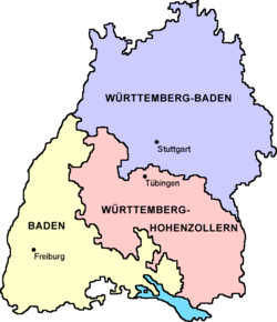
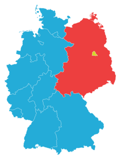
The Federal Republic of Germany (West Germany) was established in 1949 from the unification of American, British, and French occupation zones. Initially comprising 11 states, the number was reduced to 10 after the 1952 merger of Baden, Württemberg-Baden, and Württemberg-Hohenzollern into the state of Baden-Württemberg.
In 1957, the Saar Protectorate joined the republic as the state of Saarland. During this period, West Berlin held a unique status; while under Allied occupation, it was integrated into the Federal Republic as a de facto state.
Reunification and the "New States"
German reunification on October 3, 1990, integrated the former East Germany. Rather than creating a few large administrative regions, the government reconstituted five "New States" based on pre-1952 borders. East Berlin merged with West Berlin to form the city-state of Berlin, bringing the total to the current 16 states.
Administrative Structure and Subdivisions
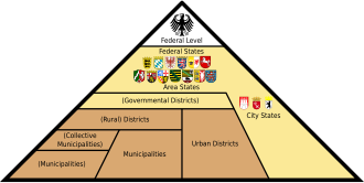
German states are further divided to manage local administration. The hierarchy generally flows from the state level down to the municipality.
- Governmental Districts (Regierungsbezirke): Intermediate administrative levels used in some states to coordinate between the state government and local districts.
- Administrative Districts (Kreise): As of 2011, there are 402 districts, including 295 rural districts (Landkreise) and 107 urban districts (Kreisfreie Städte).
- Municipalities (Gemeinden): The lowest level of local government.
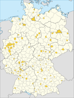
Interestingly, Germany still contains unincorporated areas—mostly forests, mountains, or lakes—that do not belong to any municipality. These are most common in Bavaria.
State Comparison Overview
The following table provides a snapshot of the diverse demographics and economic indicators across the German states (based on 2022-2023 data).
| State | Capital | Area (km²) | Population (2023) | GDP per Capita (€) | HDI (2022) |
|---|---|---|---|---|---|
| Bavaria | Munich | 70,541 | 13,176,426 | 57,343 | 0.958 |
| North Rhine-Westphalia | Düsseldorf | 34,112 | 18,017,520 | 46,194 | 0.946 |
| Baden-Württemberg | Stuttgart | 35,748 | 11,230,740 | 54,339 | 0.963 |
| Hamburg | — | 755.1 | 1,851,596 | 79,167 | 0.975 |
| Berlin | — | 891.1 | 3,662,381 | 51,209 | 0.967 |
| Bremen | Bremen | 419.4 | 702,655 | 56,981 | 0.954 |
Frequently Asked Questions
What is the difference between a Land and a Freistaat?
While all are federated states, three states—Bavaria, Saxony, and Thuringia—call themselves Freistaaten (Free States). This is an older German term for a republic, though today it is largely a traditional title and does not grant them different legal powers than other states.
How was Baden-Württemberg formed?
Baden-Württemberg was created in 1952 following a referendum. Three smaller south-western states—Baden, Württemberg-Baden, and Württemberg-Hohenzollern—merged to form the current state.
What are the "New States" of Germany?
The "New States" are the five states that were reconstituted on October 3, 1990, during the reunification of East and West Germany. These include Brandenburg, Mecklenburg-Vorpommern, Saxony, Saxony-Anhalt, and Thuringia.
Which German state is the most populous?
North Rhine-Westphalia is the most populous state, with a population of over 18 million people as of late 2023.
What are unincorporated areas in Germany?
Unincorporated areas are regions, often unpopulated forests or mountains, that are not part of any municipality. Most of these are located in Bavaria.