Drawbridge: The San Francisco Bay Area's Only Ghost Town
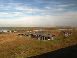
Tucked away within the marshes of the San Francisco Bay lies the remnants of Drawbridge, a settlement that once served as a vital transit hub. Now recognized as the only true ghost town in the Bay Area, Drawbridge offers a haunting glimpse into the region's railroad history and the fragile nature of isolated communities.
The Origins of Station Island
Established in 1876 by the narrow-gauge South Pacific Coast Railroad, Drawbridge was located on Station Island. The settlement began with a single small cabin designed to house the operator of two drawbridges—movable bridge sections that allow boats to pass—which spanned Mud Slough and Coyote Creek. These bridges were essential for connecting Newark with Alviso and San Jose.
During its peak, the location was a bustling transit point. Ten passenger trains stopped at the station daily, with five traveling north and five heading south.
Growth and Community Division
By the 1880s, Drawbridge had become a popular weekend destination, attracting nearly 1,000 visitors during those times. Despite the lack of connecting roads, the town grew significantly. By the 1920s, the settlement boasted 90 buildings and was split into two distinct neighborhoods based on religious affiliation: the predominantly Protestant North Drawbridge and the predominantly Roman Catholic South Drawbridge.
Access to the town remained limited, as the only path leading into Drawbridge was the Union Pacific Railroad track.
The Decline into a Ghost Town
The decline of Drawbridge began after the removal of the drawbridges and the subsequent departure of most of its residents. The town's transition into a ghost town was accelerated by a series of inaccuracies in the media. For years, the San Jose Mercury News incorrectly reported that the town was already abandoned and that residents had left valuables behind, which unfortunately led to the vandalism of homes belonging to the few remaining inhabitants.
The final resident is believed to have departed in 1979, cementing Drawbridge's status as a ghost town.
Current Status and Preservation
Today, Drawbridge is integrated into the Don Edwards San Francisco Bay National Wildlife Refuge. To facilitate restoration efforts, the site is no longer open to the general public. However, the area can still be viewed briefly by passengers traveling on the Altamont Corridor Express, Capitol Corridor, and Coast Starlight trains.
Key Facts
- Founded: 1876 by the South Pacific Coast Railroad.
- Location: Station Island, crossing Mud Slough and Coyote Creek.
- Peak Infrastructure: 90 buildings by the 1920s.
- Demographics: Divided into North (Protestant) and South (Catholic) neighborhoods.
- Final Abandonment: The last resident left around 1979.
- Current Status: Part of the Don Edwards San Francisco Bay National Wildlife Refuge.
| Era | Key Characteristics | Status |
|---|---|---|
| 1876 | Established as a railroad operator station | Founding |
| 1880s | Attracted ~1,000 weekend visitors | Growth |
| 1920s | 90 buildings; split into North and South neighborhoods | Peak |
| 1979 | Last resident departed | Abandoned |
| Present | Part of National Wildlife Refuge | Protected/Closed |
Frequently Asked Questions
Why was Drawbridge established?
It was created by the South Pacific Coast Railroad to house the operator of two drawbridges that connected Newark with Alviso and San Jose across Mud Slough and Coyote Creek.
How did people get to Drawbridge?
The town had no roads; the only path leading into the settlement was the Union Pacific Railroad track.
What caused the vandalism of the remaining homes?
The San Jose Mercury News incorrectly reported that the town was a ghost town and that valuables had been left behind, attracting vandals to the homes of the remaining residents.
Can I visit Drawbridge today?
No, the site is no longer open to the public due to restoration efforts within the Don Edwards San Francisco Bay National Wildlife Refuge.
How can I see Drawbridge now?
The site can be viewed briefly from the windows of the Coast Starlight, Capitol Corridor, and Altamont Corridor Express trains.