Drainage Basins: How Water Shapes Our World
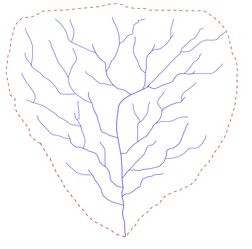
Every drop of rain that falls on land is part of a vast, interconnected journey. Whether it trickles into a small stream or flows into a massive river, that water is part of a drainage basin. A drainage basin is an area of land where all flowing surface water converges to a single point, such as a river mouth, or flows into another body of water like a lake or ocean.
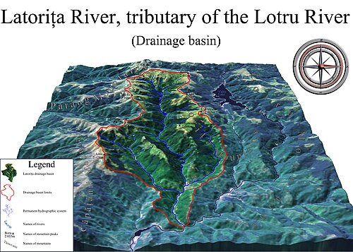
These basins are defined by their boundaries, known as drainage divides. These perimeters are typically made up of elevated features like ridges and hills that separate one basin from its neighbors. Within a single basin, smaller sub-basins often merge at river confluences, creating a complex, hierarchical pattern of water movement.
Key Facts
- Terminology: In North America, these areas are commonly called watersheds, while other regions may use terms like catchment area or river basin.
- Endorheic Basins: These are closed systems where water flows into an interior sink, such as a dry lake or salt flat, rather than reaching the ocean.
- Global Scale: Approximately 48.71% of the world's land drains into the Atlantic Ocean.
- Largest Basins: The Amazon River basin is the largest in the world, covering roughly 7 million km².
- Flooding Factors: Topography, shape, size, soil type, and land use are the primary drivers of flood risk within a catchment.
Types of Drainage Systems
Open vs. Closed Basins
Most drainage basins are "open," meaning they eventually discharge into the ocean. However, endorheic basins (closed basins) function differently. In these systems, water converges toward an interior point called a sink. This sink might be a permanent lake, an ephemeral lake, or a point where water is lost underground. Because evaporation is often the primary way water leaves these basins, the remaining water is typically more saline than ocean water—the Dead Sea being an extreme example.
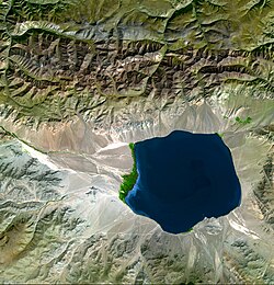
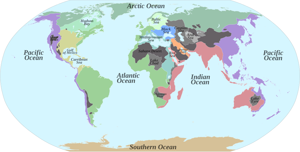
Endorheic basins cover about 18% of Earth's land. Major examples include the Caspian Sea and Aral Sea in Central Asia, the Great Basin in the United States, and the Okavango River drainage in the Kalahari Basin.
Hydrologic Units and Delineation
In scientific study, researchers use watershed delineation to map these boundaries. While all drainage basins are considered hydrologic units, not all hydrologic units are drainage basins. Hydrologic units are specifically designed to nest into multi-level hierarchical systems and can allow for multiple inlets, outlets, or sinks.
Global Water Distribution
The world's land is divided among several major ocean drainage systems:
- Atlantic Ocean: Drains about 48.71% of the world's land, including much of South America, Western Europe, and the U.S. Eastern Seaboard.
- Arctic Ocean: Drains about 17% of the world's land, covering much of Northern Canada, Alaska, and Russia.
- Pacific Ocean: Drains just over 13% of the land, including much of China, Japan, and the western United States.
- Indian Ocean: Also drains about 13% of the Earth's land, including the Indian subcontinent and the eastern coast of Africa.
| Rank | River Basin | Approximate Area (km²) |
|---|---|---|
| 1 | Amazon | 7,000,000 |
| 2 | Congo | 4,000,000 |
| 3 | Nile | 3,400,000 |
| 4 | Mississippi | 3,220,000 |
| 5 | Río de la Plata | 3,170,000 |
The Science of Catchment Factors
Understanding a catchment is vital for predicting flooding and managing resources. Several physical factors determine how water moves through a basin:
Topography and Shape
Steep mountainous terrain causes runoff to reach rivers much faster than flat plains. Similarly, the shape of the basin matters; a long, thin catchment will take significantly longer to drain than a circular one.
Soil and Land Use
The permeability of the ground dictates how much water becomes surface runoff. Sandy soils are highly free-draining, absorbing rainfall, whereas clay soils can be nearly impermeable, contributing heavily to flood volumes. Land use also plays a role; paved surfaces like roads and roofs prevent absorption, sending water directly into the river system.
Ecological and Geopolitical Importance
Drainage basins are more than just geological features; they are critical ecological and political units. As water flows, it carries nutrients, sediment, and pollutants. The use of modern artificial fertilizers can lead to eutrophication—a process where excess nutrients like nitrogen and phosphorus accelerate plant growth, potentially disturbing the natural balance at the basin's mouth.
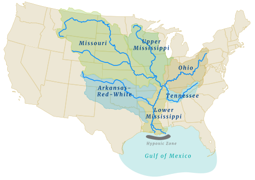
Politically, basins often define boundaries. Because water management requires cooperation, many regions use transboundary river agreements to manage shared resources. Examples include the Nile Basin Initiative and the Mekong River Commission, which help countries work together to manage water that crosses international borders.
Frequently Asked Questions
What is the difference between a watershed and a drainage basin?
In North America, the terms are often used interchangeably to describe the area of land that drains into a specific point. However, in other English-speaking regions, "watershed" refers specifically to the drainage divide line itself.
What causes a "dead zone" in a river mouth?
Dead zones can be caused by the accumulation of nutrients, such as nitrogen and phosphorus from agricultural runoff. This can lead to eutrophication, which disturbs the ecological balance in the receiving water body.
How does soil type affect flooding?
Permeable soils, like sand, allow water to infiltrate the ground, reducing runoff. Impermeable soils, like clay, or saturated soils, cause water to run off the surface, increasing the volume and speed of water entering rivers and the risk of flooding.
What is an endorheic basin?
An endorheic basin is a closed drainage system that does not flow into an ocean. Instead, water collects in an internal sink, such as a lake, or evaporates, often leaving behind salt flats or dry lakes.
Why are drainage basins important for resource management?
Because they are coherent hydrological units, managing water based on the basin allows for more effective control of water resources. Many countries and states use basin-based management to handle water supply, pollution, and flood control.