Croatia Geography and Environmental Overview
Croatia is a high-income, developed country located in the Northern and Eastern Hemispheres. Situated within Eurasia, it occupies a strategic position in Southern Europe, specifically within the regions of Central Europe and Southeast Europe, the latter of which is commonly referred to as the Balkans.
The nation operates on Central European Time (UTC+01) and observes Central European Summer Time (UTC+02) during the warmer months.
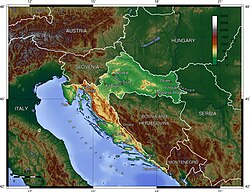
Key Facts
- Total Area: 56,542 km² (21,831 sq mi).
- Population: 3,827,227 (as of 2026).
- Highest Point: Dinara at 1,831 m (6,007 ft).
- Lowest Point: Adriatic Sea at 0 m.
- Coastline: 5,835 km along the Adriatic Sea.
- Primary Ethnicity: Croats.
Physical Geography and Boundaries
Croatia's landscape is defined by its extensive maritime access and diverse land borders. The country shares a total of 1,982 km of land boundaries with five neighboring nations. The longest border is with Bosnia and Herzegovina (932 km), followed by Slovenia (455 km), Hungary (329 km), Serbia (241 km), and Montenegro (25 km).
In addition to its land borders, Croatia maintains a 595 km maritime boundary with Italy. Its most striking feature is the vast 5,835 km coastline bordering the Adriatic Sea, which supports numerous inhabited and uninhabited islands.
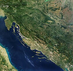
Natural Features and Environment
The environmental profile of Croatia is diverse, encompassing various geological formations, mountains, and river systems. The country is home to several protected areas and national parks that preserve its unique wildlife, including a wide array of mammals and birds.
| Feature | Detail/Measurement |
|---|---|
| Highest Elevation | Dinara (1,831 m) |
| Lowest Elevation | Adriatic Sea (0 m) |
| Total Land Borders | 1,982 km |
| Total Coastline | 5,835 km |
| Maritime Border (Italy) | 595 km |
Regional and Administrative Structure
Croatia is divided into several distinct geographical regions, including Central Croatia, Dalmatia, Istria, Gorski Kotar, Međimurje, Slavonia, and Zagorje. These regions reflect the varied terrain and cultural history of the country.
Administrative Divisions
The country utilizes a two-level administrative system. The first level consists of the Counties of Croatia and the City of Zagreb. The second level is further divided into municipalities and cities.
The counties include:
- Bjelovar-Bilogora, Brod-Posavina, and Dubrovnik-Neretva
- Istria, Karlovac, and Koprivnica-Križevci
- Krapina-Zagorje, Lika-Senj, and Međimurje
- Osijek-Baranja, Požega-Slavonia, and Primorje-Gorski Kotar
- Sisak-Moslavina, Split-Dalmatia, and Šibenik-Knin
- Varaždin, Virovitica-Podravina, and Vukovar-Syrmia
- Zadar and Zagreb County
Frequently Asked Questions
What is the highest point in Croatia?
The highest point in Croatia is Dinara, which reaches an elevation of 1,831 meters (6,007 ft).
Which countries share a land border with Croatia?
Croatia shares land borders with Bosnia and Herzegovina, Slovenia, Hungary, Serbia, and Montenegro.
How long is the Croatian coastline?
The coastline along the Adriatic Sea extends for 5,835 km.
What are the primary administrative divisions of Croatia?
The first-level administrative divisions are the various counties of Croatia and the City of Zagreb, while the second level consists of municipalities and cities.
In which global regions is Croatia located?
Croatia is located in the Northern and Eastern Hemispheres, within Southern Europe, Southeast Europe (the Balkans), and Central Europe.