Corral Hollow Canyon: The History of Tesla and Carnegie
Nestled within the landscapes of California, Corral Hollow Canyon is a region defined by its deep ancestral roots and a volatile industrial past. From its beginnings as a sacred precinct for Native American peoples to its era as a powerhouse of coal and clay production, the canyon has witnessed the rise and fall of entire communities. Today, it stands as a site of ecological and cultural significance, transitioning from a hub of industry to a focal point for conservation.
The canyon's geography served as a natural corridor for movement long before the arrival of European settlers. The Spanish referred to the local waterway, Corral Hollow Creek, as El Arroyo de los Buenos Ayres, meaning "The Creek of the Good Winds."
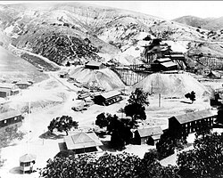
Key Facts
- Ancestral Lands: The area is within the traditional homelands of the Yokuts and Ohlone peoples.
- Industrial Peak: The Tesla Mine was California's largest coal producer from 1896 to 1905.
- Lost Towns: The towns of Tesla and Carnegie were both abandoned following a devastating flood in 1911.
- Conservation Victory: In 2022, California law banned the use of the Tesla area for off-road vehicles.
Pre-Contact and Early European Influence
Long before colonial contact, the region was occupied by the Yokuts and Ohlone peoples. Archaeological evidence indicates that the Tesla area served as a sacred precinct. Along the creek, numerous bedrock mortars—stone depressions used by Native Americans to grind seeds and acorns—remain as testaments to their long-term habitation.
European presence began with explorers and travelers. Juan Bautista de Anza is believed to be the first European to pass through the canyon during a side trip between San Francisco and Monterey, accompanied by Joaquin Murrieta and Tiburcio Vasquez. This route became formalized as El Camino Viejo, an old Spanish colonial trail.
El Camino Viejo was a vital artery for Spanish and Mexican Vaqueros (cattle drivers) and later became a primary route for gold-seekers during the California Gold Rush. In 1850, Edward B. Carrell became one of the first non-Native settlers, establishing the "Zink House" tavern to serve travelers. Carrell's home remains a California Historical Landmark.
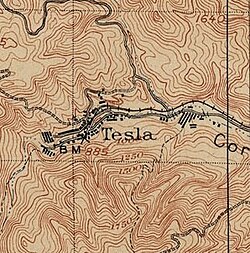
The Industrial Rise of Tesla and Carnegie
The discovery of coal in 1855 transformed the canyon into an industrial center. In 1856, John O'Brien discovered coal deposits that led to the creation of the Pacific Coal Mining Company, co-owned by Edward Carrell. After several ownership changes and failures, the mine was purchased and reopened by James and John Treadwell, who renamed it the Tesla Mine in honor of Nikola Tesla.
By the 1890s, the Tesla Mine was a massive operation, averaging 500 tons of coal daily. The surrounding town of Tesla grew rapidly, eventually housing 1,500 residents and 200 buildings. The Treadwells expanded their empire by establishing the Carnegie Brick and Pottery Company about four miles away. This plant used clay extracted from Tesla to manufacture pottery and bricks, spawning the town of Carnegie, which reached a population of approximately 2,000.
The Collapse of the Mining Towns
The prosperity of Tesla and Carnegie was short-lived. A series of financial and natural disasters struck in the early 20th century:
- Financial Ruin: The 1906 earthquake and the collapse of the California Safe Deposit Bank depleted the Treadwells' finances.
- Industrial Accidents: The operations were plagued by boiler room explosions and repeated flooding.
- The Final Blow: A catastrophic flood in 1911 destroyed the railroad and mining infrastructure. Unable to afford repairs, the company abandoned both towns.
Modern Conservation and Land Use
In 2001, the California Off-Highway Motor Vehicle Recreation Division (OHMVR) purchased land around Tesla to expand the Carnegie State Vehicular Recreation Area (CSVRA), which would have permitted off-road vehicle use. This proposal met strong opposition from ecological and community groups, including the Sierra Club, the California Native Plant Society (CNPS), the Greenbelt Alliance, Save Mount Diablo, and the Friends of Tesla Park.
The conflict concluded in 2022 when the California state budget's Public Resources Trailer Bill included a section banning the area from being declared a state vehicular recreation area. Currently, conservation groups are advocating for the state to classify Tesla as a natural or cultural reserve to ensure its permanent preservation.
| Feature | Tesla | Carnegie |
|---|---|---|
| Primary Industry | Coal Mining | Brick and Pottery |
| Peak Population | ~1,500 | ~2,000 |
| Key Resource | Coal | Clay |
| Fate | Abandoned 1911 | Abandoned 1911 |
Frequently Asked Questions
Who were the original inhabitants of Corral Hollow Canyon?
The area is within the ancestral homelands of the Yokuts and Ohlone peoples, who used the region as a sacred precinct and utilized bedrock mortars for grinding seeds and acorns.
Why was the Tesla Mine significant in California history?
The Tesla Mine was the largest coal-producing mine in California between 1896 and 1905, producing an average of 500 tons of coal per day during the 1890s.
What caused the abandonment of the towns of Tesla and Carnegie?
A combination of the 1906 earthquake, the failure of the California Safe Deposit Bank, boiler explosions, and a final devastating flood in 1911 led to their total abandonment.
What is the current status of the land around Tesla?
Following a long legal and ecological struggle, the state of California banned off-road vehicle use in the area in 2022. Conservationists are now seeking to have it designated as a natural or cultural reserve.