Cilicia: A Historical and Geographical Journey Through Southern Turkey
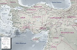
Cilicia is a region of profound historical depth and geographical contrast located in modern-day Turkey. Spanning the provinces of Adana, Mersin, Osmaniye, and Hatay, it has served as a vital bridge between Asia and the Mediterranean for millennia. From its rugged mountains to its fertile plains, Cilicia has been home to a diverse array of civilizations, including the Luwians, Persians, Romans, Armenians, and Turks.
Key Facts
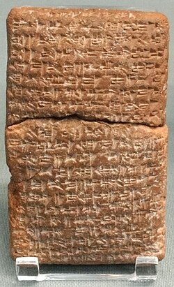
- Location: Southern Turkey, encompassing Adana, Mersin, Osmaniye, and Hatay.
- Geography: Divided into two distinct zones: Rough Cilicia (mountainous) and Plain Cilicia (fertile lowlands).
- Population: Approximately 6,435,986 as of 2022.
- Major Cities: Adana (largest city), Tarsus, and Mersin.
- Economic Strength: Historically a center for cotton trade; currently a hub of agriculture and commerce.
- Historical Significance: Former satrapy of the Achaemenid Empire and later the center of the Kingdom of Cilician Armenia.
Geography and Climate
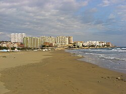
Cilicia is characterized by two contrasting landscapes. Rough Cilicia consists of the rugged, mountainous terrain of the interior, while Plain Cilicia is defined by its fertile lowlands, watered by the Berdan (Cydnus) and Seyhan (Sarus) rivers.
The climate varies significantly by elevation. The lower plains experience a typical Mediterranean climate with hot summers and mild winters, making the eastern plains exceptionally fertile. In contrast, the mountains feature an inland climate with snowy winters. Mersin and its surrounding areas are the warmest parts of the region and receive the highest annual precipitation, averaging 1,096 mm.
Ancient History and the Bronze Age
The earliest recognizable mentions of Plain Cilicia date back to between 2000 and 1750 BC. The Story of Sinuhe, written during the reign of Senusret I, refers to a ruler with a Luwian title, indicating that the ruling class of the period were Luwians (an ancient Anatolian people). Egyptian inscriptions from the reign of Amenemhat II also mention the port city of Ura.
![Probable captives from Cilicia, on the Nasiriyah stele of Naram-Sin, circa 2200 BC.[32]](/images/39/4f/394f5576cbac7b91ee5017742f7dc14c4086e8504d520721aa5b15d8df487e60.jpg)
The Kingdom and Satrapy of Cilicia
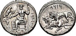
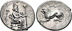
By the 6th century BC, the Kingdom of Cilicia was established with Tarsus as its capital. Around 542 BC, the region submitted to the Achaemenid Empire, eventually becoming a satrapy (a provincial governorate) by 401 BC. Notable satraps included Camisares, Datames, and Mazaeus.
Roman, Byzantine, and Medieval Eras
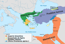
Cilicia later became part of the Roman Empire, serving as a strategic province in Asia Minor. Following the Roman and Byzantine periods, the region saw the rise of Cilician Armenia (1199–1375), a kingdom that acted as a significant power during the Crusades.
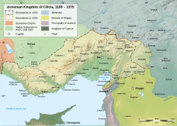
The Armenian rule ended in 1375 when the Mamluk Sultanate took control of the region. The Mamluks authorized the Ramadanids, a Turkmen Emirate, to administer the land, though the Mamluks maintained direct control over key towns like Tarsus and Ayas.
Ottoman Rule and the Modern Era
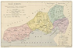
The Ottoman Empire ended Ramadanid administration in 1608, ruling the region directly from Constantinople. In the 19th century, Cilicia briefly fell under the de facto control of Egypt under Muhammad Ali Pasha before returning to Ottoman sovereignty in 1840. The American Civil War later boosted the region's economy, as European traders turned to Cilicia for cotton.
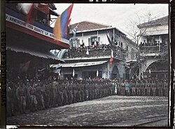
Following World War I, the region was occupied by French forces. However, the Treaty of Ankara (1921) led to the French withdrawal in January 1922, and Cilicia became part of the Republic of Turkey. This transition was marked by significant demographic shifts, including the population exchange of Greeks and the migration of Armenians to Lebanon and Argentina.
Regional Overview and Administration
Today, Cilicia is a densely populated region known for its agricultural productivity and urban centers.
| Province | Seat | Area (km²) | Population (2022) |
|---|---|---|---|
| Mersin | Mersin | 15,853 | 1,891,145 |
| Adana | Adana | 14,030 | 2,263,373 |
| Osmaniye | Osmaniye | 3,767 | 553,012 |
| Hatay | Antakya | 5,524 | 1,670,712 |
Cultural and Religious Legacy
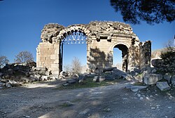
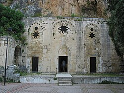
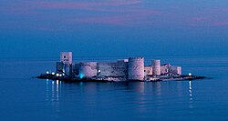
Cilicia's history is reflected in its diverse cultural remnants. Ancient Achaemenid Cilicia showed a blend of Persian and local influences, evidenced by Aramaic inscriptions and coins minted in Soli and Tarsus. Religious sites, such as the Church of Saint Peter near Antakya and the fortress of Kızkalesi, continue to attract visitors today.
Frequently Asked Questions
What are the two main geographical regions of Cilicia?
Cilicia is divided into Rough Cilicia, which is mountainous and has an inland climate, and Plain Cilicia, which consists of fertile lowlands with a Mediterranean climate.
Who were the Luwians in the context of Cilician history?
The Luwians were an ancient Anatolian people who formed the ruling class of Plain Cilicia during the Bronze Age, as indicated by titles found in texts like the Story of Sinuhe.
What was the significance of the Achaemenid period in Cilicia?
Under the Achaemenid Empire, Cilicia became a satrapy with Tarsus as its capital, fostering a culturally diverse society with Persian, Aramaic, and local influences.
How did the American Civil War affect Cilicia?
The war disrupted the flow of cotton to Europe, leading traders to seek alternatives in the fertile plains of Cilicia, which transformed the region into an economic powerhouse for the Ottoman Empire.
When did Cilicia become part of the Republic of Turkey?
Cilicia officially became part of the Republic of Turkey in 1921 following the signing of the Treaty of Ankara, which ended the French occupation.