Chaco Province: A Comprehensive Look at Argentina's Northeastern Heartland
Located in the northeast of Argentina, Chaco (officially the Province of Chaco) is a region of vast lowland plains, diverse linguistic heritage, and significant agricultural output. Bordered by the provinces of Formosa, Corrientes, Santa Fe, Salta, and Santiago del Estero, as well as the Paraguayan department of Ñeembucú, Chaco serves as a vital link in the southern part of the Gran Chaco region.
With its capital in Resistencia, the province is the twelfth largest by area and the eleventh most populated in Argentina. It is a land defined by its relationship with water—bounded by the Paraná, Paraguay, and Bermejo rivers—and a history of resilience and cultural blending.
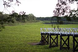
Key Facts
- Capital: Resistencia
- Established: August 8, 1951
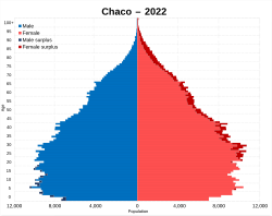
- Population: 1,142,963 (2022 Census)
- Area: 99,633 km²
- Official Languages: Spanish, Wichí, Toba, and Mocoví
- Primary Economy: Cotton, quebracho wood, and livestock
- HDI Rank: 24th (0.808) as of 2021
Etymology and Origins
The name Chaco is derived from the Quechua word chaku, which refers to a traditional hunting technique used by the Inca Empire. This method involved large groups of hunters circling prey, such as vicuñas and guanacos, to capture them. The term was documented as early as 1589 in a letter by Juan Ramírez de Velasco, the Governor of Tucumán, who referred to the region as Chaco Gualamba.
Geography and Climate
Chaco is situated within the Gran Chaco, a massive lowland plain spanning Argentina, Paraguay, and Bolivia. The terrain is generally flat, with the highest point reaching 272 meters near Taco Pozo in the west.
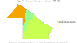
Climate Zones
The province features a subtropical climate divided into two distinct zones:
- Eastern Zone: A humid subtropical climate (Cfa) with no dry season, receiving approximately 1,400 mm of annual precipitation.
- Western Zone: A semi-arid climate (BS) characterized by dry winters and lower overall precipitation.
Temperature and Humidity
Mean annual temperatures range between 21 and 23°C. Summers are intense, often reaching 38 to 41°C in the east and frequently exceeding 40°C in the west. Winters can bring polar air from the south, resulting in frosts and temperatures below freezing. High humidity is common, particularly in the north, with frequent fogs during the winter months.
History and Development
The region was originally home to hunter-gatherers from the Mataco-Guaicru language family, including the Toba and Wichí peoples. One of the most striking features of the landscape is the Campo del Cielo (Heavenly Fields), a protected area where iron meteorites fell four to five thousand years ago during the Holocene epoch.
European settlement began in 1585 with the founding of Concepción de Nuestra Señora by Alonso de Vera y Aragón, though it was abandoned by 1632. The modern city of Resistencia grew from a military outpost established in 1876.
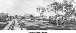
20th Century Evolution
In the late 19th and early 20th centuries, the province saw an influx of immigrants, including Mennonites and Volga Germans from Canada, Germany, and Russia. These settlers transformed the region into a productive hub for beef and dairy farming.
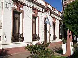
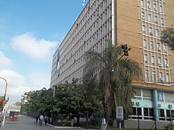
Politically, the territory became a province in 1951 and was briefly named Provincia Presidente Perón before reverting to Chaco in 1955. The province's administrative growth is reflected in its government buildings, some of which faced significant delays due to political disputes.
Economy and Infrastructure
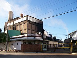
Chaco's economy is diversified but heavily reliant on agriculture. The province is a national leader in cotton production, accounting for 60% of Argentina's total output. Other key crops include soy, sorghum, maize, sugarcane, rice, and tobacco.
The industrial sector contributes about 10% to the economy, focusing on textiles, sugar, alcohol, paper, and the extraction of oil and coal. Livestock farming utilizes Zebu crosses, which are better adapted to the region's heat and flooding than pure breeds.
Transportation and Social Indicators
Infrastructure has historically been a challenge. Following the privatization of national railways in the 1990s, the province established SEFECHA (Servicios Ferroviarios del Chaco S.A.), which remains a critical public commuter rail service carrying nearly a million passengers annually.
Despite economic recovery since 2002, Chaco faces significant social challenges. It has historically struggled with high poverty rates and malnutrition, ranking low in GDP per capita among Argentine provinces.
Administrative Summary
| Category | Detail |
|---|---|
| Total Area | 99,633 km² |
| Population (2022) | 1,142,963 |
| GDP (Total) | US$ 16.5 billion |
| GDP Per Capita | US$ 13,500 |
| Official Languages | Spanish, Wichí, Toba, Mocoví |
| Administrative Divisions | 25 Departments |
Frequently Asked Questions
What are the official languages of Chaco?
In 2010, Chaco became the second province in Argentina to adopt multiple official languages. Alongside Spanish, the indigenous languages of Kom, Moqoit, and Wichí are officially recognized.
What is the significance of Campo del Cielo?
Campo del Cielo is a protected region on the border of Chaco and Santiago del Estero. It is the site of a massive meteorite impact that occurred four to five thousand years ago, leaving behind significant deposits of meteoric iron.
What is the primary agricultural product of the province?
Cotton is the most significant agricultural product, with Chaco producing 60% of Argentina's national cotton supply. The province also produces substantial amounts of soy, maize, and sorghum.
How does the climate vary across the province?
The province is split into two zones: the east is humid subtropical with rainfall throughout the year, while the west is semi-arid with drier winters and more extreme temperature variations.
What is SEFECHA?
SEFECHA (Servicios Ferroviarios del Chaco S.A.) is a publicly owned commuter rail service. It was established in 1997 to maintain essential rail connectivity after the privatization of the national railway system.