Castle Valley and Emery County History
The landscape of Castle Valley in Emery County, Utah, is a living chronicle of human endurance and adaptation. From the ancient artists who left their mark on sandstone walls to the pioneers who carved farming communities out of the arid soil, the region's history is defined by its imposing geography and the diverse groups of people who traversed it.
Prehistoric Foundations
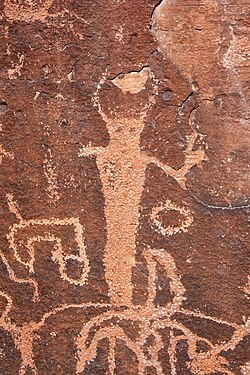
Human occupation of the San Rafael region spans thousands of years. The area was first inhabited by people of the Desert Archaic Culture, who were later succeeded by the Fremont culture between the sixth and thirteenth centuries AD. These early civilizations left behind a rich legacy of rock art, including pictographs (paintings on rock) and petroglyphs (carvings in rock).
Significant archaeological sites listed on the National Register of Historic Places include Temple Mountain Wash, Muddy Creek, Ferron Box, Black Dragon Canyon, and Buckhorn Wash. Additionally, the indigenous Ute people occupied various sites throughout Castle Valley.
The Old Spanish Trail and Early Exploration
The first non-indigenous visitors to Castle Valley were Spanish traders and explorers. In 1776, Silvestre Vélez de Escalante recorded the first crossing of northern Utah via the Uintah Basin. Soon after, a more southerly route emerged, known as the Old Spanish Trail.
This extensive trail connected Santa Fe to the coast, passing through Durango, Colorado, and crossing the Colorado River near Moab. To avoid the steep-walled canyons of the San Juan, Colorado, Green, Dirty Devil, and San Rafael Rivers, travelers were forced to traverse Castle Valley. The trail passed through key landmarks such as Buckhorn Flat, Huntington Creek, and Muddy Creek before heading south toward Las Vegas, Nevada, and Barstow, California.
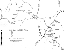
Historically, the trail served two primary, often illicit, purposes: the trade of Indian women and children (slavery) between Santa Fe and the Utah region, and the herding of horses from California to Santa Fe. Because the slave trade was illegal, few formal records of these travels exist. However, it was these travelers who gave the region the name "Castle Valley," inspired by the dramatic rock formations.
American Trappers and Government Scouts
In 1809, "lost trappers" James Workman and William Spencer entered the valley after being separated from their party by Comanche Indians. They joined a Spanish caravan to reach California. Later, in 1830, William Wilfskill and his party followed the Spanish Trail but found the area unsuitable for long-term trapping.
By the mid-19th century, the U.S. government sent explorers to find viable overland routes. Kit Carson traversed the valley in the late 1840s while seeking a mail route from St. Louis to California, famously bringing news of the 1848 Sierra Nevada gold rush. In 1853, Army Topographical Engineer John W. Gunnison plotted a potential railroad route under the commission of Secretary of War Jefferson Davis. Gunnison's detailed records show he charted a path around the rugged Sinbad Reef.
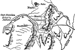
The final major government explorer of this era was John C. Fremont (1853–54), whose expedition suffered severely from food shortages and extreme winter weather until reaching the settlement of Parowan.
Pioneer Settlement and the Birth of Emery County
The transition to permanent settlement began in 1875 when livestock growers from Sanpete County identified the region's grazing and settlement potential. Driven by land shortages in Sanpete and the desire of LDS Church leaders to secure the land, families began homesteading in 1877 in areas that would become Huntington, Ferron, Castle Dale, and Orangeville.
On August 28, 1877, Brigham Young ordered at least fifty families to locate in Castle Valley. This became the last Mormon colony established under his direction; Young passed away just one week later on August 29. Early settlers focused on the fertile bottom lands along Huntington, Cottonwood, and Ferron Creeks, establishing sawmills and irrigation ditches by 1878.
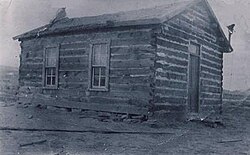
The Utah Territorial Legislature officially created Emery County on February 12, 1880, naming it after Governor George W. Emery. While the 1880 census recorded 556 people, the population grew to 2,866 by 1890. This era saw the construction of vital irrigation projects, including the Huntington, Emery, and Cleveland canals.
Industrialization and 20th Century Challenges
As the population grew, so did the complexity of land management. By 1900, over 25,000 acres were under cultivation, but this led to severe water rights conflicts and "midnight irrigation" (water theft). Furthermore, the region's ancient seabed soils contained high salt levels. Over-irrigation caused these salts to rise to the surface, leading a 1903 Department of Agriculture report to note that over 30% of developed farmland had been abandoned.
The economy diversified with the expansion of the coal industry. While World War I brought a temporary boom in wages and agricultural prices, the 1920s and 1930s were marked by economic collapse. The Great Depression, coupled with severe droughts in 1931 and 1934, saw coal production drop by half and agricultural prices plummet by 40%.
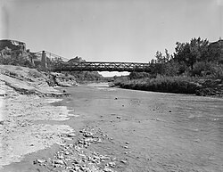
Relief came via the Civilian Conservation Corps (CCC), which established camps in Joes Valley, Ferron, Castle Dale, and Green River. The CCC built the roads, bridges, and ranger stations that modernized the county's infrastructure.
Modern Era and Mining
Post-World War II years brought modernization, including telephones and improved sanitation. The 1970s saw a population surge due to the construction of large coal-fired power plants in Castle Dale and Huntington by Utah Power & Light Company (PacifiCorp).
However, the mining industry has been marked by tragedy. In December 1984, a fire at the Wilberg Mine killed 27 people. More recently, on August 6, 2007, a collapse at the Crandall Canyon Mine trapped six workers 1,500 feet underground, an event that registered as a magnitude 3.9 to 4.0 seismic event.
Key Facts
- Ancient Heritage: Inhabited by Desert Archaic and Fremont cultures; known for extensive rock art panels.
- The Old Spanish Trail: A historic route used for livestock herding and the illegal slave trade.
- Last Colony: Emery County was the final settlement directed by Brigham Young before his death in 1877.
- Agricultural Struggle: High soil salinity from ancient seabeds led to the abandonment of 30% of farmland by 1903.
- Economic Drivers: Transitioned from livestock and farming to a heavy reliance on coal mining and power generation.
| Period/Year | Event/Development | Significance |
|---|---|---|
| 6th–13th Century AD | Fremont Culture | Creation of regional pictographs and petroglyphs. |
| 1776 | Escalante Expedition | First recorded non-indigenous view of the region. |
| 1877 | LDS Settlement | Establishment of Huntington, Ferron, and Castle Dale. |
| 1880 | County Formation | Official creation of Emery County. |
| 1933–1938 | CCC Camps | Infrastructure development during the Great Depression. |
| 2007 | Crandall Canyon Collapse | Major mining disaster causing seismic activity. |
Frequently Asked Questions
Who were the first people to live in Castle Valley?
The region was first occupied by the Desert Archaic Culture, followed by the Fremont culture between the 6th and 13th centuries AD, and later by the indigenous Ute people.
What was the primary purpose of the Old Spanish Trail?
The trail was used for herding livestock (primarily horses) from California to Santa Fe and for the illegal trade of Indian women and children.
Why did so much farmland in Emery County fail in the early 1900s?
The soil consisted of ancient seabeds with high salt content. Poor drainage and over-irrigation caused these salts to accumulate on the surface, making the land unsuitable for crops.
What role did the CCC play in the region?
The Civilian Conservation Corps established camps in Joes Valley, Ferron, Castle Dale, and Green River, where they built essential roads, bridges, trails, and ranger stations.
How did the railroad affect the development of the county?
Because the route over the Wasatch Range was too steep, the railroad bypassed most settlements, limiting economic growth for much of the county except for the town of Green River.