Cape Coral Infrastructure: A Comprehensive Overview
Cape Coral is defined by its unique engineering and strategic planning, blending an extensive aquatic network with modern land-based transportation and pioneering utility systems. From its world-renowned canal system to its innovative approach to water purification, the city's infrastructure supports both its residential growth and its connection to the wider Florida region.
The Extensive Canal System
One of the most striking features of the city is its network of over 400 miles (640 km) of canals. Most of these waterways are navigable, providing many residents with direct waterfront living. This system allows access to the Gulf of Mexico via the Matlacha Pass and the broad Caloosahatchee River.
The scale of this network is so vast that it has influenced local tides and the surrounding ecology. To support maritime activity, the Parks and Recreation Department maintains three public boat launching facilities, enabling residents and visitors to reach sports fishing grounds, rookeries, and small tropical islands in the Gulf of Mexico.
Roadways and Bridge Connectivity
Cape Coral is supported by approximately 1,100 miles (1,800 km) of roadways. The city's layout features arterial roads with north-south routes typically spaced every one to two miles (3.2 km), most of which consist of at least four lanes.
Major regional connectivity is provided by Interstate 75, located within 10 miles (16 km) of the city, linking Cape Coral to Tampa in the north and Miami to the southeast. Additionally, the city borders U.S. Highway 41, and both I-75 and U.S. 41 are accessible via State Route 78 (Pine Island Road).
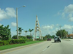
Crossing the Caloosahatchee River
The city is linked to the south side of the Caloosahatchee River by two primary bridges:
- Cape Coral Bridge: A 3,400-foot (1,000 m) span connecting Cape Coral Parkway to College Parkway in McGregor.
- Midpoint Memorial Bridge: A connection between Veterans Parkway and Colonial Boulevard in Fort Myers.
Looking toward the future, the City of Cape Coral and the Lee County Department of Transportation plan to construct a new westbound span for the Cape Coral Bridge in 2026. This $185 million project aims to replace the 1964 span, which no longer meets county requirements. Improvements will include expanding both spans to six lanes, adding a pedestrian bridge, removing the toll booth on the Fort Myers side, and expanding the intersection of Del Prado Boulevard and Cape Coral Parkway.
Transportation and Transit
Public transportation is managed by LeeTran, which operates 18 fixed-route bus services, six of which serve the Cape Coral area.
For air travel, residents have access to three primary airports:
- Southwest Florida International Airport (RSW): Located 14 miles (23 km) away, this hub serves nearly 10 million passengers annually. As of 2010, it was served by 18 national airlines, two international airlines, and two major cargo companies.
- Page Field: A general aviation airport in Fort Myers, located 8 miles (13 km) from the city.
- Punta Gorda Airport (PGD): Located 10 miles (16 km) north of Cape Coral.
Utilities and Technological Innovation
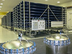
Cape Coral has a history of pioneering utility management. In 1977, it became the first municipality in the United States to implement reverse osmosis—a water purification process that uses a semi-permeable membrane to remove ions and molecules—on a large scale. The initial capacity was 3,000,000 US gallons per day, growing by 1985 to the world's largest low-pressure reverse osmosis plant with a capacity of 15 million gallons per day (MGD).
The city also employs an advanced sewage system that produces reclaimed water, known locally as "rescued water." This treated water is distributed via a dual pipe system for irrigation purposes or discharged into the Caloosahatchee River.
In the realm of public safety, Cape Coral was an early adopter of the 4.9 GHz pre-WiMax wireless channel, authorized by the FCC in 2003 for exclusive use by public safety agencies.
Key Facts
- Canals: Over 400 miles of navigable waterways.
- Roads: Approximately 1,100 miles of city roadways.
- Water Innovation: First U.S. city to use large-scale reverse osmosis (1977).
- Bridge Project: A $185 million upgrade to the Cape Coral Bridge is planned for 2026.
- Air Access: Proximity to RSW, Page Field, and Punta Gorda airports.
| Category | Key Detail | Metric/Value |
|---|---|---|
| Waterways | Total Canal Length | 400+ miles (640 km) |
| Roads | Total Roadway Length | ~1,100 miles (1,800 km) |
| Water Utility | Max Reverse Osmosis Capacity (1985) | 15 MGD |
| Transit | LeeTran Fixed-Route Services | 18 total (6 in Cape Coral) |
| Aviation | Distance to RSW Airport | 14 miles (23 km) |
Frequently Asked Questions
How does the canal system benefit residents?
The canal system provides extensive waterfront living and allows residents to navigate to the Gulf of Mexico via the Caloosahatchee River and Matlacha Pass for fishing and island exploration.
What are the planned upgrades for the Cape Coral Bridge?
Scheduled for 2026, the $185 million project includes a new westbound span, expansion to six lanes on both spans, a new pedestrian bridge, the removal of the Fort Myers toll booth, and intersection expansions.
What is "rescued water" in Cape Coral?
"Rescued water" is the local term for reclaimed water, which is highly treated sewage used primarily for irrigation through a dual water pipe system.
Which airports serve the Cape Coral area?
The area is served by Southwest Florida International Airport (RSW) for commercial and international flights, Page Field for general aviation, and Punta Gorda Airport (PGD).
What was Cape Coral's contribution to water purification?
Cape Coral was the first U.S. municipality to use the reverse osmosis process on a large scale starting in 1977, eventually operating the world's largest low-pressure reverse osmosis plant by 1985.