Ben Wyvis: The Majestic Peak of Easter Ross
Rising prominently above the farmland of Strathconon, Ben Wyvis (Scottish Gaelic: Beinn Uais) is a striking mountain located in Easter Ross, within the northern Highlands of Scotland. Characterized by its distinctive whale-back shape, the mountain consists of a large, undulating ridge that stretches roughly north-south for 5 kilometers. For hikers and nature enthusiasts, it represents a blend of challenging terrain, rich geological history, and critical biodiversity.
The mountain is recognized as both a Munro (a Scottish mountain over 3,000 feet) and a Marilyn (a hill with a prominence of at least 150 meters). Its highest point, Glas Leathad Mòr, reaches an elevation of 1,046 meters (3,432 ft).
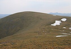
Key Facts
- Highest Point: Glas Leathad Mòr at 1,046 m (3,432 ft).
- Location: Easter Ross, Highland council area, Scotland.
- Geology: Primarily composed of Moine pelitic gneiss and Moine schist.
- Conservation Status: National Nature Reserve (NNR), Special Protection Area (SPA), Special Area of Conservation (SAC), and Site of Special Scientific Interest (SSSI).
- Key Species: A vital breeding ground for the dotterel, supporting at least 2.4% of the Great Britain population.
Geography and Landscape
Ben Wyvis is defined by its winding ridge and high plateau. To the south, it is separated from the Corbett of Little Wyvis by the Bealach Mòr (a mountain pass). The surrounding infrastructure includes the A835 road and the Kyle of Lochalsh railway line to the south and west. To the northeast lies Loch Glass, while the northwest region remains largely uninhabited and mountainous.
Summit Peaks
The ridge features several notable high points beyond the main summit:
- Glas Leathad Mòr: The primary summit at 1,046 m.
- Tom a' Chòinnich: A Munro Top at 953 m.
- An Cabar: A Munro Top at 946 m.
- Glas Leathad Beag: A Munro Top and HuMP at 928 m.
Geology and Formation
The mountain is primarily composed of Moine schist, a metamorphic rock formed from sediments deposited between 1,000 and 870 million years ago in shallow seas. Over time, heat and pressure transformed these sediments into hard, water-resistant rock. The subsequent Caledonian orogeny—a major mountain-building event—created the folds and waves visible in the rock today.
During the Ice Age, glaciers carved the mountain's corries and glens. Evidence of this era remains in the form of glacial erratic boulders, which suggest that while much of the mountain was covered by ice sheets, the very top of Ben Wyvis remained ice-free.
History and Heritage
Historically, Ben Wyvis sat on the northern edge of the lands held by Clan Munro. Local tradition claims the clan held their land from the Crown on the condition that they provide a snowball at midsummer if requested—a task made possible by the perennial snow found in the mountain's corries.
The area was also a site of conflict, most notably the Battle of Bealach nam Broig around 1452. This clash saw clans allied with Clan Mackenzie fight against north-eastern clans, including Clan Munro, who supported the Earl of Ross.
From the sixteenth century until the early twentieth century, the mountain's southern flanks served as a shortcut for cattle drovers traveling between northwest Scotland and southern markets. Remains of a settlement at Garbat and iron workings along the Allt á Bhealaich Mhòir provide evidence of this economic era.
Nature and Conservation
Ben Wyvis is a sanctuary for rare flora and fauna. The summit plateau is dominated by woolly hair-moss (Racomitrium lanuginosum), creating a springy carpet that is essential for the nesting of dotterel. Other rare plants include the dwarf birch and alpine foxtail.
The mountain supports a diverse array of wildlife:
- Birds: Rock ptarmigan, European golden plover, red grouse, common ravens, peregrine falcons, and golden eagles.
- Insects: Pearl-bordered fritillary, large heath butterfly, large red damselfly, and golden-ringed dragonfly.
- Mammals: Scottish red deer, sika deer, roe deer, mountain hares, and pine martens.
To protect the vegetation from overgrazing, NatureScot manages deer numbers through an annual cull.
The Ben Wyvis National Nature Reserve
Established in 1982 and managed by NatureScot, the National Nature Reserve (NNR) covers the western and southern slopes and the summit plateau. It is classified as a Category II protected area by the IUCN. The reserve protects a mosaic of habitats, from native woodlands and shrub-rich heath on the lower slopes to upland moorlands and high crags.
Due to the fragility of the moss-heath, NatureScot has implemented restoration projects since 2011 to combat erosion caused by hikers. These efforts include traditional path-building and the transplantation of vegetation to encourage visitors to stay on a single, sustainable route.
Tourism and Access
Most visitors ascend Ben Wyvis from the west, starting at a car park south of Garbat on the A835. Hikers typically follow the Allt a' Bhealaich Mhòir through the forest before climbing toward An Cabar or Tom a' Choinnich. Under the Scottish Outdoor Access Code, the public has a right of responsible access for walking, cycling, and wild camping across both public and private lands.
| Feature | Detail |
|---|---|
| Highest Point | Glas Leathad Mòr (1,046 m) |
| Prominence | c. 691 m |
| Parent Peak | Beinn Dearg |
| Primary Rock Type | Moine schist / pelitic gneiss |
| Key Habitat | Woolly hair-moss heath |
| Reserve Status | NNR, SPA, SAC, SSSI |
Frequently Asked Questions
What does the name Ben Wyvis mean?
The name likely comes from the Scottish Gaelic Beinn Uais, meaning "high or lofty mountain." An alternative theory suggests it may derive from Beinn Uabhas, meaning "mountain of terror."
Why is the woolly hair-moss important?
The woolly hair-moss covers the summit plateau and provides a critical nesting habitat for the dotterel; Ben Wyvis supports at least 2.4% of the dotterel breeding population in Great Britain.
How is the mountain's geology unique?
It is primarily composed of Moine schist formed 870 to 1,000 million years ago. The rock shows evidence of metamorphism and the Caledonian orogeny, as well as glacial erratic boulders from the Ice Age.
Can I legally camp or hike on Ben Wyvis?
Yes. Under the Scottish Outdoor Access Code, there is a right of responsible access for activities such as walking, cycling, horse-riding, and wild camping, regardless of whether the land is privately or publicly owned.
What are the main hiking routes?
The most common route starts at the A835 car park south of Garbat, ascending via the Allt a' Bhealaich Mhòir to reach An Cabar or Tom a' Choinnich, often combined into a circular trek.