Aqueduct Walk: The History and Evolution of a Bronx Landmark
In the heart of the West Bronx lies Aqueduct Walk, a unique linear park that serves as a living monument to New York City's struggle for clean water. What began as a critical piece of 19th-century infrastructure has evolved over nearly two centuries into a vital community space and a recognized city scenic landmark.
The Quest for Fresh Water
By the 18th century, Manhattan's original freshwater sources—including its streams, lakes, and springs—had been eliminated or polluted by urban growth. The crisis reached a breaking point in the 1830s, as the city suffered from a devastating cholera outbreak in 1832 and the Great Fire of 1835. These disasters highlighted the failure of the existing system of cisterns and wells.
To solve this, the city looked north to the Croton River watershed in the Hudson Valley. Construction of the old Croton Aqueduct began in 1837 under the direction of chief engineer John B. Jervis. The project was a massive undertaking, employing up to 4,000 laborers who often faced poor working conditions and low wages. The Bronx portion of the system was constructed during the third and fourth phases of the project.
The aqueduct officially opened in 1842, providing New York City with its first direct supply of fresh water and dramatically improving public hygiene. While the New Croton Aqueduct was later built starting in 1885 to meet growing demand, a small section from the Bronx to Manhattan remained in use after most of the original system was abandoned in 1917.
Early Use and the Bicycling Craze
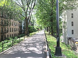
Almost from its inception, the embankment supporting the aqueduct in the West Bronx served as an informal walkway. In the 1840s, the renowned poet Edgar Allan Poe, who lived in a nearby cottage in Fordham, was a frequent visitor to the path. By 1881, the route was described as a turf-covered roof adorned with greenery, cutting through a landscape that remained largely undeveloped between the High Bridge and Kingsbridge Road.
By the 1890s, the smooth surface of the path attracted early cyclists. However, the route was often interrupted by fences and walls, leading to frequent accidents. This prompted a push for official recognition; in 1895, a bill to convert the route into a formal bike path was passed by the State Legislature, though it was ultimately vetoed by Governor Levi P. Morton. Despite this, the city acquired adjacent land for "highway purposes" in 1896 to accommodate the growing demand for recreational space.
Conversion into a Public Park
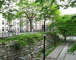
The transition from infrastructure to public park began in earnest in 1929. When the city proposed selling the right-of-way, local organizations, the Bronx Chamber of Commerce, and the Park Association of the City of New York fought to preserve the land for civic use. In 1930, the New York City Department of Parks and Recreation (NYC Parks) obtained the surface rights, while the Department of Water Supply retained the subsurface portions to protect the active water line.
Throughout the 1930s, the area—initially called the "Aqueduct Lands"—underwent significant improvements. Architect Gilmore David Clarke was hired in 1938 to redesign the space, adding recreation courts, play areas, benches, and retaining walls. The park officially opened as "Aqueduct Walk" on April 26, 1940.
Modern Era and Landmark Status
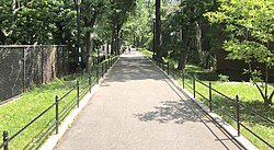
Throughout the mid-to-late 20th century, Aqueduct Walk remained a community hub, hosting everything from shuffleboard games to a 1920 marathon. However, the park faced periods of decline. By the 1990s, officials noted issues with vandalism, litter, and broken pavement, though the park continued to see high usage from pedestrians and cyclists using it as a shortcut.
The 21st century brought a series of targeted investments. The Aqueduct Lands Playground was renovated in 2008 using funds from the Croton Water Filtration Plant mitigation fund. More recently, MLK Plaza was rededicated in 2019 in honor of Roscoe C. Brown Jr., a Tuskegee Airman and former president of Bronx Community College. A new brick restroom facility was also completed for $1 million.
In a historic milestone, Aqueduct Walk was designated as the Bronx's first official New York City scenic landmark on April 16, 2024, recognizing its geographic and cultural significance to the community.
Key Facts
- First Water Supply: The Croton Aqueduct provided NYC's first direct freshwater supply upon opening in 1842.
- Famous Visitor: Poet Edgar Allan Poe frequently walked the embankment in the 1840s.
- Landmark Status: Designated as the first official NYC scenic landmark in the Bronx on April 16, 2024.
- Infrastructure: The park sits atop a subsurface water line, which limited the type of construction NYC Parks could perform.
- Community Honor: MLK Plaza was rededicated in 2019 to honor Tuskegee Airman Roscoe C. Brown Jr.
| Year/Period | Event/Development | Significance |
|---|---|---|
| 1837–1842 | Construction of Old Croton Aqueduct | Established first direct freshwater supply to NYC |
| 1890s | Rise of cycling on the embankment | Shift toward recreational use of the right-of-way |
| 1930 | NYC Parks obtains surface rights | Prevented sale of land to private developers |
| 1940 | Official opening of Aqueduct Walk | Formal transition to a public city park |
| 2024 | Scenic Landmark Designation | First official scenic landmark in the Bronx |
Frequently Asked Questions
Why was the Croton Aqueduct originally built?
It was built to provide New York City with a reliable source of fresh water after the city's local springs and streams became polluted, a crisis highlighted by the 1832 cholera outbreak and the 1835 Great Fire.
Who is Edgar Allan Poe's connection to the park?
Poe lived in a cottage in Fordham, Bronx, during the 1840s and frequently walked along the aqueduct's embankment during his time there.
Why is the park's construction limited?
Because the Department of Water Supply retains ownership of the subsurface portions of the right-of-way to protect the water line, NYC Parks cannot perform significant heavy construction on the embankment.
What is the significance of the 2024 landmark designation?
Aqueduct Walk became the first official New York City scenic landmark located in the Bronx, recognizing the area's cultural and geographic importance.
How was the recent renovation of MLK Plaza funded?
The renovation was funded through a combination of $2 million from the mayor's office, $600,000 from the City Council, and $333,000 from the borough president's office.