Aleppo Governorate
The Aleppo Governorate is one of the fourteen administrative divisions of Syria. As the most populous governorate in the country, it held an estimated population of over 4.86 million people in 2011, representing nearly 23% of Syria's total population. Covering an area of approximately 18,482 square kilometers, it accounts for about 10% of the nation's total landmass. The administrative capital is the historic city of Aleppo.
Key Facts
- Capital: Aleppo
- Population: 4,868,111 (2011 estimate)
- Total Area: 18,482 km²
- Administrative Divisions: 10 Districts (Manatiq)
- Primary Languages: Syrian Arabic and Kurmanji Kurdish
- Highest Point: Mount Bulbul (1,269 meters)
- Lowest Point: Maṭkh swamp (249 meters)
Historical Evolution
Ancient and Classical Eras
In classical antiquity, the region was divided into three primary areas: Chalybonitis (centered at Aleppo), Chalcidice (centered at Qinnasrin), and Cyrrhestica (centered at Cyrrhus). This region was historically the most fertile and densely populated part of Syria. By 193 CE, the Romans integrated the area into the province of Coele-Syria (or Magna Syria), governed from Antioch. Later, in the 4th century CE, the province of Euphratensis was established to the east, with its center at Hierapolis Bambyce (modern-day Manbij).
Islamic and Ottoman Rule
Following the early Islamic conquests, the region became part of the Jund Qinnasrin under the Rashidun and Umayyad dynasties. During the Abbasid period, the Hamdanids exercised independent rule over the area. Governance eventually passed to the Mamluks and subsequently the Ottoman Empire until 1918, during which time the region was organized as the Vilayet of Aleppo.
During the Ottoman Tanzimat era, the 1858 land reform law and Bedouin settlement schemes strengthened Aleppo's economic ties with Anatolia. However, these changes also allowed European capitalists and merchants to gain significant control over the region's agricultural resources and internal trade.
Modern Era and Conflict
In the early 20th century, the region was briefly part of the State of Aleppo under the French Mandate. The governorate's boundaries were later adjusted around 1960 when the Idlib Governorate was split off.
Since 2011, the governorate has been a central theater of the Syrian Civil War. By June 2017, the territory was divided among Syrian Government forces, Syrian Opposition forces, the Turkish Army/TFSA, and the Syrian Democratic Forces (SDF). The Syrian Arab Army, supported by Russian air power, regained control of Aleppo city in December 2016. Other major operations include Turkey's 2016 Operation Euphrates Shield to remove ISIS from border towns like Jarabulus, Azaz, and Al-Bab, and the 2018 operation in Afrin against the YPG.
Geography and Environment
Terrain and Topography
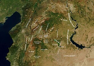
The governorate is situated on the Aleppo plateau, with an average elevation of 379 meters. The landscape generally slopes from north to south and west to east. To the north, it shares a 221-kilometer border with Turkey. The northeastern section extends into the Jazīrah plateau via the Euphrates valley, while the southeast blends into the arid Syrian Desert, known locally as the Aleppo Desert.
Key geographical features include Mount 'Aqīl, Mount Ḥaṣṣ, and Mount Simeon. The highest point in the region is Mount Bulbul, reaching 1,269 meters. The region is largely deforested, with the exception of a small forest area on the eastern slope of Mount Kurd, primarily consisting of oak and Aleppo pine.
Hydrology and Agriculture
Arable land covers 66% of the governorate. Major crops include grains, rice, vegetables, olives, figs, plums, pomegranates, and the famous fustuq Ḥalabī (Aleppo pistachio). While the region is crossed by several rivers—including the Quwēq, 'Ifrīn, Sājūr, Dhahab, Aswad, and Euphrates—most originate in Turkey. Irrigation projects upstream have significantly reduced water flow; for instance, the Quwēq river dried up completely in the 1950s, forcing a reliance on rainfall and Euphrates water diverted via a pumping station at Maskanah.
The largest natural water body is the Sabkhat al-Jabbul salt lake, a Ramsar-protected site. The Euphrates Lake serves as the boundary between Aleppo and Raqqa governorates.
Archaeology
The governorate is rich in archaeological sites, particularly in the Limestone Massif region. This area contains the world's highest concentration of Late Antiquity churches and the renowned Dead Cities of Syria.
Administrative Structure
The governorate is divided into ten districts (manatiq), which are further subdivided into 46 sub-districts (nawahi). The following table summarizes the primary administrative centers based on the 2004 census.
| City | Population (2004) |
|---|---|
| Aleppo | 2,132,100 |
| Manbij | 99,497 |
| As-Safira | 63,708 |
| Al-Bab | 63,069 |
| Kobani | 44,821 |
| Afrin | 36,562 |
| Azaz | 31,623 |
| Dayr Hafir | 18,948 |
| Jarabulus | 11,570 |
| Atarib | 10,657 |
Climate
Aleppo Governorate experiences a semi-arid climate. The Mediterranean influence is largely blocked by the Mount Alawites and Mount Amanus ranges, creating a rain shadow effect. Average temperatures range between 15°C and 20°C. Precipitation is concentrated between October and March, varying from 500 mm in the west to as little as 150 mm in the southeastern desert.
Economy
The economy is traditionally rooted in agriculture, specifically cotton and cereal production. However, the Syrian Civil War has caused severe economic deterioration, leading to price inflation and the relocation of many businesses across the border to Gaziantep, Turkey. Recent challenges include the 2022 Russian invasion of Ukraine and falling Euphrates water levels, both of which threaten food security, electricity, and water access.
Frequently Asked Questions
What is the most significant agricultural product of the region?
The region is well-known for its pistachios, referred to locally as fustuq Ḥalabī (Aleppo pistachio), alongside olives, grains, and cotton.
How has the water supply in Aleppo changed over time?
Many of the region's rivers originate in Turkey. Due to upstream irrigation projects, flows have dropped significantly—the Quwēq river dried up in the 1950s—forcing the region to rely on rainfall and water pumped from the Euphrates.
What are the "Dead Cities" of Syria?
The Dead Cities are a collection of ancient archaeological sites located in the Limestone Massif, featuring a unique Syrian architectural style and the world's largest concentration of Late Antiquity churches.
Which governorates border Aleppo?
Aleppo is bordered by Raqqa Governorate to the east, Hama Governorate to the south, and Idlib Governorate to the west. It also shares a long northern border with Turkey.
What is the current administrative status of the governorate?
The governorate is divided into ten districts (manatiq), including the capital city of Aleppo, and is governed by a Governor.