Aintab Plateau: Geography and Geological Significance of Southeastern Anatolia
The Aintab plateau, also known as the Gaziantep plateau, serves as a critical geographical bridge in the westernmost part of Turkey's Southeastern Anatolia Region. This low, gently undulating landscape is not only a site of historical importance—once forming the region of Commagene in antiquity—but also a significant geological landmark where the Arabian plate meets the Anatolian sub-plate at the East Anatolian Fault.
Spanning the Turkish provinces of Gaziantep, Kilis, and Adıyaman, the plateau is characterized by its gradual slopes and strategic position. The city of Gaziantep (Aintab) is situated nearly in the south-center of this expansive region.
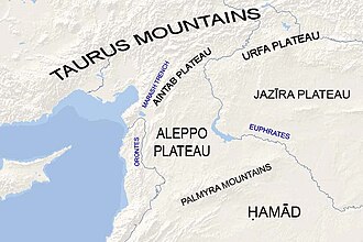
Key Facts
- Location: Westernmost part of Turkey's Southeastern Anatolia Region.
- Geology: Northwestern end of the Arabian plate meeting the Anatolian sub-plate.
- Average Elevation: 800 meters.
- Highest Peaks: Akdag (2,552 m) in the northern Adıyaman Province.
- Primary Vegetation: Sparse forests consisting mainly of pine and oak.
- Major Waterways: The Euphrates River and various tributaries including the Alleben and Sajur.
Geographical Layout and Elevation
The plateau's topography varies significantly from north to south. While the average elevation sits at 800 meters, the northern and north-northwestern areas feature peaks exceeding 1,000 meters. Conversely, the southern and eastern regions transition into plains ranging from 375 to 600 meters in height.
Geographically, the Aintab plateau is a continuation of the Aleppo plateau. It slopes gently upward in a southeast–northwest direction, rising to form the Aintab plateau approximately midway between Aleppo and Gaziantep. This connection is further evidenced by Mount Kurd, Mount Simeon, and Mount ʻAqīl, which serve as extensions of the Aintab plateau into the Aleppo region.
Boundaries and Borders
The plateau is defined by distinct natural boundaries:
- East: Bounded by the Manbij plain and the valley of the Euphrates River.
- North: Bounded by the Taurus Mountains.
- West: Defined by the Maraş triple junction, a valley running from Maraş to Antakya that separates the Nur Mountains from the Sof (Qarṭal) Mountains.
Hydrology and Terrain
The plateau's water systems are largely defined by their flow toward the Euphrates. In the western region, the Sof Mountain (1,496 m) and Karadağ mountain (1,081 m) act as primary watersheds. The Alleben and Sajur rivers originate from Sof Mountain, flowing southeast across the plain of Tall Bashar to join the Euphrates. Similarly, the Merzimen (Bozatlı) river and the River Afrin also rise from Sof Mountain.
Other significant waterways include the Nizip Stream, which joins the Euphrates near the city of Nizip, and the Kara-su (River ʼAswad), which flows through the Araban Plain and the southern half of the Maraş-Antakya valley before meeting the Euphrates.
The Adıyaman Highlands
In the northern Adıyaman Province, the terrain becomes more rugged. The southern area along the Euphrates consists of highlands separated by rivers flowing from the steep Taurus Mountains, including the Kahta, Göksu, Sofras, and Ziyaret. In this specific sector, plains account for only 10% of the total area, typically sitting between 600 and 700 meters above sea level.
The northern portion of Adıyaman is dominated by the Malatya Mountains, which are foothills of the Taurus range. This area contains the plateau's highest elevations, including Akdag (2,552 m), Dibek (2,549 m), and Tucak (2,533 m).
Regional Summary Table
| Feature | Details |
|---|---|
| Provinces | Gaziantep, Kilis, Adıyaman |
| Average Elevation | 800 m |
| Key Mountains | Sof (1,496 m), Karadağ (1,081 m), Akdag (2,552 m) |
| Major Rivers | Euphrates, Alleben, Sajur, Kara-su, Afrin |
| Vegetation | Sparse pine and oak forests |
Frequently Asked Questions
What is the geological significance of the Aintab plateau?
The plateau marks the northwestern end of the Arabian plate, where it meets the Anatolian sub-plate at the East Anatolian Fault.
Which mountains are the highest in the region?
The highest peaks are located in the Malatya Mountains (foothills of the Taurus Mountains) in Adıyaman Province, with Akdag reaching 2,552 meters.
How does the Aintab plateau relate to the Aleppo plateau?
The Aintab plateau is a continuation of the Aleppo plateau, sloping upward in a southeast–northwest direction between the two cities.
What are the primary water sources of the plateau?
The region is drained by several rivers and streams, most notably the Euphrates River and its tributaries such as the Alleben, Sajur, and Kara-su.
What is the typical vegetation found on the plateau?
Forests are scarce in this region, but where they exist, the dominant tree species are pine and oak.