A96 Road: Connecting Aberdeen and Inverness
The A96 is a critical transport artery in the north of Scotland, serving as the primary link between the city of Aberdeen and the city of Inverness. Spanning approximately 102 miles (164 km), this major road facilitates the movement of people and goods across the Highlands and Aberdeenshire, connecting several key towns and hubs.
The route begins at the Mounthooly roundabout, just north of Aberdeen city centre, and travels generally west and northwest. From its starting point, it exits the city and meets the A92 at the Haudagain Roundabout, a junction known for high traffic volumes. After passing through Bucksburn and providing access to Aberdeen Airport, the road operates as a dual carriageway (a road with two or more lanes of traffic in each direction) until it reaches Inverurie, where it transitions into a single carriageway.
From Inverurie, the A96 continues its journey through a series of towns and bypasses, including Huntly, Keith, Fochabers, Elgin, Forres, and Nairn, before finally terminating at the A9 on the outskirts of Inverness.
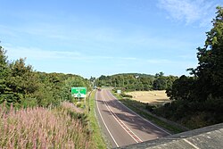
Key Facts
- Total Length: 102 miles (164 km).
- Termini: Aberdeen (South end) and Inverness (Northwest end).
- Primary Destinations: Aberdeen, Inverurie, Huntly, Elgin, and Inverness.
- Former Status: Previously part of the Euroroute system as route E120.
- Major Infrastructure: Includes the Inveramsay Bridge and the Fochabers bypass.
Route History and Infrastructure Improvements
Over the last several decades, the A96 has undergone significant modifications to improve traffic flow and safety. During the 1980s and 1990s, several bypasses were constructed to divert traffic away from town centres, specifically in Auldearn, Forres, Lhanbryde, Huntly, and Inverurie.
The Fochabers Bypass
The development of the Fochabers bypass was a long-term project. While a bridge over the River Spey was built around 1970 to align with a potential northern route, the actual bypass construction did not begin until February 2, 2010. The new route, situated north of Fochabers and south of Mosstodloch, officially opened in January 2012.
The Inveramsay Bridge
To resolve chronic congestion northwest of Inverurie, the Inveramsay Bridge was constructed. The previous bridge passed under the Aberdeen-Inverness railway line and was too narrow for two tall vehicles to pass simultaneously, necessitating the use of traffic lights. The new bridge carries the road over the railway line, removing this bottleneck.
Future Upgrades and Environmental Concerns
Despite these improvements, the A96 has faced criticism for its safety record on single carriageway sections and has been voted as one of the most unpopular roads in Scotland.
The Dualling Project
In 2016, the Scottish Government announced an ambitious plan to upgrade the A96 to a full dual carriageway by 2030. With an estimated cost of £3 billion, the project aims to dual the remaining 88 miles (142 km) of single carriageway between Aberdeen and Inverness. The first phase of this project is an 18-mile (29-kilometre) section between Inverness and Auldearn, which includes a bypass for Nairn.
Environmental and Social Impact
The proposed expansion has met with opposition from environmental advocates. Patrick Harvie of the Scottish Greens has argued that such large-scale road expansions are incompatible with the government's climate initiatives. Additionally, there are significant concerns regarding the potential loss of ancient woodland along the route.
Active Travel Initiatives
To support non-motorized transport, cycle paths have been integrated into the infrastructure. A path already exists between Kintore and Port Elphinstone, and work began in October 2021 to create a shared cycle and footpath between Lhanbryde and Fochabers.
Route Summary
| Feature | Details |
|---|---|
| Total Distance | 102 mi (164 km) |
| Start Point | Mounthooly roundabout, Aberdeen |
| End Point | A9, Inverness |
| Key Towns Served | Inverurie, Huntly, Keith, Elgin, Forres, Nairn |
| Planned Investment | £3 billion for dualling |
Frequently Asked Questions
Where does the A96 start and end?
The A96 begins at the Mounthooly roundabout in Aberdeen and terminates at the A9 outside of Inverness.
What is the current status of the A96 dualling project?
The Scottish Government announced plans in 2016 to dual the remaining 88 miles of the road by 2030, starting with the section between Inverness and Auldearn, including the Nairn bypass.
Why was the Inveramsay Bridge replaced?
The original bridge passed under the railway line and was too narrow for two tall vehicles to pass at once, causing significant traffic congestion. The new bridge passes over the railway to eliminate this issue.
What environmental concerns are associated with the A96 upgrades?
Critics, including the Scottish Greens, argue that dualling the road contradicts climate goals and threatens the preservation of ancient woodlands.
Are there facilities for cyclists on the A96?
Yes, cycle paths have been developed in specific areas, including a path between Kintore and Port Elphinstone and a shared cycle/footpath between Lhanbryde and Fochabers.